
| No | Name | Description |
|---|---|---|
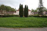 |
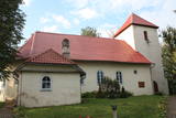
Vieta, ko nekādi nevar uzskatīt par tūrisma objektu, bet tajā pat laikā tas ir Latvijas mērogā nozīmīgs kultūras un vēstures piemineklis, ko nevar nepieminēt! Laikā no 1923. – 1943. gadam muižas pilī atradās Latvijā zināmākā mājturības skola, kurā mācījās izslavētās kaucmindietes! Tagad muižas pils ir pamesta, avārijas stāvoklī un apskatāma tikai no ārpuses un „pa gabalu”. Ap 1780. gadu celtā pils, kas 1909. – 1912. g. tika pārbūvēta pusloka būvapjomā, ir Latvijai diezgan unikāls arhitektūras paraugs. |
|
 |
The restaurant is at the Chocolate Museum in Pūre. The terrace offers a lovely view of the ancient Abava River valley. The men changes on the basis of the seasons and demand. Latvian cuisine: Chilled soup, sorrel soup, sautéed peas and carrots, liver stroganoff, oatmeal dessert, milk gelatine with berry sauce. Special foods: Dishes with Pure Chocolate products and garnishes. |
|
 4 days
|
This is for birders who can’t afford to take longer breaks to enjoy birdwatching. Short but rewarding trip during spring migration. Cape Kolka is a place where pass the largest numbers of migrating birds in the spring time. More than several tenth of thousand birds cross the Cape each hour. During active period of migration it is possible to see more than 100 different species daily just at this one place. There are several birdwaching places located at different biotops – seaside meadows, sea cost and lakes and wetlands. Kemeri National Park is one of the best places for woodepecker watching. In a short period of time it is possible to see about seven species. |
|
 |
A gift shop in the old town of Cēsis near Rose Square, in the building of the former hotel "Baltischer Hof". The shop is named after the hotel's former owner, Karlīne. It is possible to buy gifts, handicraft items, souvenirs, as well as delicious homemade products, homemade wines and spirits here. |
|
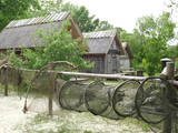 |
This is a very interesting monument to the history of fishing in the region. These areas had docks and areas where fishermen built huts to store their nets and other inventory. The areas also had a social role – men came together to discuss work that had to be done, while women and children wove nets. The huts at Bigauņciems were eventually washed into the sea, and the areas at Ragaciems have been partly destroyed. The ones at Lapmežciems are the ones which are best preserved. One of the net huts has been restored, but the others are in very poor condition, indeed. That may be why you should focus on these huts as you walk along the beach. Make sure that you take some pictures of this historic location. |
|
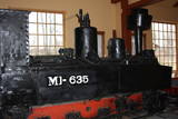 |
In 1916, during the German military occupation of Latvia, prisoners of war were put to work in installing narrow-gauge railroads via which the Germans exported Latvian timber. A narrow-gauge rail network was built through the forests and across the swamps of the Viesīte area. The track width was round 600 mm, and there was a total of 130 km of tracks to connect Viesīte (the central station) to Nereta, Aknīste, Jēkabpils and Daudzeva. The train was used after world War II to transport timber and passengers. The last trip along the line occurred on August 31, 1972.
You can tour the museum individually or with the assistance of a guide. You’ll see an Mi-635 locomotive, wagons for passengers and cargo, a platform to transport timber materials, and two trolleys.
|
|
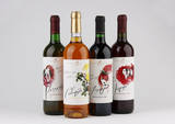 |
This venue produces homemade fruit, berry and dandelion wine from local products and with no preservatives, as well as interesting products such as spicy plum sauce and fruit and berry conserves. Groups of tourists can go on a tour and taste and purchase the products. |
|
 |
The wooden tower was built and stands 28 metres high. It is at the top of the highest hillock of the Northern Courlandian Highlands – Kamparkalns Hill (175 metres above sea level). The tower offers one of the loveliest views in the region of the hillocks of Talsi. On a clear day, you can see all the way to the Bay of Rīga and Talsi. |
|
 |
The hosts produce mixtures of dried herbs and vitamin tea in a full cycle - from seeds to a packet of spices. The farm beds and greenhouses grow a wide range of vegetables and herbs - dill, onions, garlic, chives, mint, sage, thyme, coriander, hyssop, tarragon, peppermint, chili, basil. Also used wild plants - nettle, gooseberry, viburnum, dandelion, yarrow, oregano. |
|
 12 days
|
The tour introduces visitors to varied landscapes, local traditions and historic sites. Travellers are usually surprised that such a small territory holds so many contrasts. Riga offers a medieval Old Town and elegant Art Nouveau district, then comes Sigulda with three castles on the high banks of the Gauja river valley. Saaremaa island is a pleasure to drive around with good quality, quiet roads, windmills, medieval churhes and ethnographic villages. Tallinn has its walled Old Town while Lahemaa national park has an almost mystical landscape There is also elegant Palmse Manor. The tour goes through sleepy villages in eastern Latvia with distinctive pottery, ancient culinary traditions, and the Catholic pilgrimage site of Aglona. Vilnius' historic centre has distinctive baroque churches. The massive sand dunes of the Curonian Spit and Nida with its characteristic blue framed windows are among Lithuania's most attractive sights. Trakai has its picturesque medieval castle on the lake as well as the small Karaitis ethnic comunity with their unique traditions and food. Port towns Klaipeda and Liepaja have both developed into bustling modern cities with lively cafe culture. |
|
 6 days
|
For the introduction into the Latvian craftsmanship make a visit to the Open-Air Ethnographic Museum in Riga where skillful masters will show you traditional skills. Out of Riga visit birch juice and wine maker which tells and shows how the birch juice is extracted and how preserved. You could taste it as well. Then go the area connected with ancient historic legends. Visit the museum of famous Latvian hero Lacplesis to see there Lielvarde Belt where the story is written using ancient secret symbols. At Koknese have a Viking boat trip around the picturesque Koknese castle ruins. Then visit farm which grows hemp and makes traditional hemp butter, goats farm and home-made traditional beer producer. Latgale region is famous for its pottery schools and "black" ceramics. You visit few workshops on the way as well as Ludzas Crafts Centre which provides great insight into local traditions. At the typical Latgalian farm try traditional sauna ritual and have proper regional meal. Further on stop at the Aglona Basilica which is a pilgrimage place. But for stomach pleasures visit Bread Museum, farm which produces tasty cheeses and other healthy diary products as well as visit herbal tea maker and learn there few health tips. Sightseeing of Daugavpils historic centre, impressive 19th century' s fortress are followed by visit to Lead Shot Factory where is a biggest shot towers in Europe which still works. On the way to Riga visit impressive Baltic pearl - Rundale Palace. |
|
 |
The castle was commissioned by Baron Alexander von Fittinghof and built between 1859 and 1863 in the late Tudor Neo-Gothic style. It is one of the most important monuments to this style in Latvia and has an ornate limestone façade. The 7th Sigulda Infantry Brigade was housed in the castle from 1921 until 1940. Today it is home to the Alūksne Museum with a permanent exhibition and an “environmental labyrinth.” One of the most unusual exhibits is a set of fluorescent minerals that can be viewed under lights with various spectrums. |
|
 |
This labyrinth covers 3,300 m2. Visitors can make their way through the maze, trying to find the exit and handling clever tasks at some of the special twists and turns in the labyrinth. There is a playground for children, along with a workshop, a mud café and the “fir tree village.” |
|
 |
Atrodas 0,5 km ziemeļaustrumos no Dzērbenes baznīcas, ceļa otrajā pusē. Vizuāli izteiksmīgs pilskalns ar 50 x 50 m lielu plakumu, kura kultūrslānī atrastas vēlā dzelzs laikmeta apmetnes atliekas. Pilskalna rietumu nogāzē ir izveidots ceļš, pa kuru nonāksim līdz tā plakumam ar estrādi. |
|
 |
Celta ~ 1560. g. vietā, kur agrāk atradusies Sakas osta. Dievnamā apskatāms > 170 gadus vecs kuģa modelis. Vietējie ticēja, kas tas aizsargā jūrniekus un bojāejas. Šāda tradīcija Latvijā ir novērojama tikai dažās baznīcās. Baznīcu var apskatīt arī no iekšpuses. |
|
 |
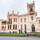
The castle, built in 1880 by von Pistolkors family, has been renovated and awaits guests in its new splendour. Guesthouse 78km from Riga. Premises for banquets, wedding, seminars. Sauna, swimming pool. Cultivated landscape.
|
|
 |
Family farm near Valmiera with large fields, meadows and 400 cows. Production of cream, cottage cheese, yoghurt, cheese, ice-cream and other products from the farm's milk. |
|
 |
Renda is a very old town, first mentioned in historical sources in 1230. During the 13th century, Renda was one of the centres of the ancient Courlandian land of Vanema. When Courland was split up in 1235, Renda was taken over by the German Order, and local residents were forcibly drafted into its military. During the age of the Duchy of Courland (1562-1795), the region flourished despite wars, the bubonic plague and other problems, particularly during the rule of Duke Jacob (1642-1682). During the 17th century, Renda became something of a manufacturing centre, churning out timber products, with local lime kilns, watermills, flax weaving facilities, a glass factory and a boiling house for saltpetre and soap. Wine, perfumes and barrels were produced in Renda, as was cast iron for nails and many other things. The court at the Jelgava Castle loved the sour wines from Renda. All of this was destroyed during the Great Northern War (1700-1721). During the 19th century, a chemicals factory was built on the site of the burned Renda castle, and nearby was one of the largest leather tanning plants in Kurzeme, along with a manufacturing facility for turpentine. Cultural life began to develop in parallel to this. Renda suffered much during the two world wars and the subsequent Soviet repressions. The so-called Courelian Battalion of partisans went into the forests after the occupation to continue their struggle against the Soviet regime. Renda today is a small and quiet village with the Lielrenda Estate, a local church, the “devil’s boat” at the Abava River, and the Īvande waterfalls. |
|
|
|
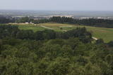
The viewing tower is on the western part of the Blue Hills of Ogre, not far from the Dubkalni quarry. Paths lead to the tower, as does a wooden staircase. The viewing platform offers a very broad view of the Ķegums hydroelectric power plant reservoir and the towers of
|
|
 |
This institution offers a look at characteristic rituals that relate to environmental transformation, as well as at ancient Baltic faiths. Family and calendar celebrations are held here, including weddings, hen parties, consecration, mid-winter activities, etc. Some of these are pagan festivals. The educational programmes are meant for adults. |
|


