
| No | Name | Description |
|---|---|---|
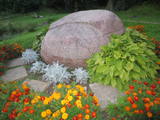 |
Located in the south-eastern part of Piedruja and on the banks of the Daugava River, the rock can be accessed via the local path or a local land road. The rock was sculpted by Vilnis Titāns, who engraved the name of the Daugava River in seven languages – Latvian, Livonian, Estonian, Polish, Russian, German and Finnish. Opposite the rock is Druja, which is in Belarus, as well as a large island that splits the river in two. A temporary permit is needed to visit Piedruja. |
|
|
|
Established in 1992, the Mežacīruļi farm is in the Zaļenieki Parish of the Jelgava Administrative District, alongside the basin of the Lielupe River. The farm initially had 7.2 ha of land, 3 cows, 20 head of sheep and 6 sows. Today it has 700 ha of land, 300 dairy cows, and a series of hothouses to grow lettuce and herbs. |
|
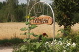 |
This is a new farm that produces cheese and waits for groups of visitors. People can help to make cheese and taste and buy it. Lejnieki won a prize as the most orderly working farm in the Valka Administrative District. |
|
 |
The outworker offers different garlic and other vegetable products: marinated garlic flowers, different mixed vegetables; dried garlic rusks, etc. The groups are offered food tasting. |
|
 |
The recently renovated viewing tower offers a wonderful view of the impressive and forested ancient Gauja River valley. The Gūdu cliffs are visible. This is part of the Līgatne nature trails territory, where there are wide paddocks of wild animals.
|
|
 |
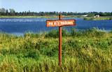
Apdzīvota vieta ~ 1 km dienvidos no Daugavpils – Krāslavas (A 6) ceļa, kas pazīstama ar savu neparasto nosaukumu. Interesanti, ka vietvārds saistīts arī ar iedzīvotāju uzvārdiem, ko var redzēt tāda paša nosaukuma kapos. Ciema apkaimē pazīstams ir Lielo Muļķu svētavots, kuru gan nezinātājam ir grūti atrast, tādēļ ieteicams izmantot vietējā gida pakalpojumus, apvienojot šīs vietas izziņu ar biškopības saimniecības „Cīruļi” apskati. |
|
 |
A restricted area with a set of artificial ponds to the South-west of Saldus. The ponds attract many different kinds of birds during nesting and migration season. The location has not been improved for tourist purposes, but it is still an interesting place for some bird-watching. The forests around the ponds are also home to many protected birds and species of bat. |
|
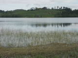 |
This nature park was established to protect the Burzava hillocks, Lake Adamova (a eutrophic lake), and the habitats and species that are found along the lake’s shores – bats included. The loveliest views of the area can be viewed from the hillocks that are on the northern shore of the lake. There are tourist accommodations on the shores of Lake Adamova where tourists can spend the night. |
|
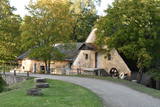 |
Jaunpils ūdensdzirnavas ir industriālā tūrisma apskates objekts, kurā ir saglabājusies dzirnavu iekārta, kas darbojusies 20. gs. 20.−30. gados, kā arī hidrotehniskās būves un ūdenskrātuve. Šobrīd dzirnavās ir izveidota ekspozīcija par pašām dzirnavām, malšanas procesu un graudkopību. |
|
 |
The Krimulda Castle was built in the latter half of the 13th century. It was located where the right bank of the ancient Gauja River valley is split by the deep Vikmeste ravine. The castle was owned by the council of archbishops from Rīga, and it was an impressive structure with a large interior courtyard and a defensive wall that was 1.5 m thick. The Swedish military blew up the castle when retreating in 1601. Today the castle hill is forested, and only a small fragment of the castle wall can still be seen. It is near the ruins that you will find the Sigulda aerial tram and the Krimulda serpentine road – the only object of its kind in the Baltic States. |
|
 |
Renda is a very old town, first mentioned in historical sources in 1230. During the 13th century, Renda was one of the centres of the ancient Courlandian land of Vanema. When Courland was split up in 1235, Renda was taken over by the German Order, and local residents were forcibly drafted into its military. During the age of the Duchy of Courland (1562-1795), the region flourished despite wars, the bubonic plague and other problems, particularly during the rule of Duke Jacob (1642-1682). During the 17th century, Renda became something of a manufacturing centre, churning out timber products, with local lime kilns, watermills, flax weaving facilities, a glass factory and a boiling house for saltpetre and soap. Wine, perfumes and barrels were produced in Renda, as was cast iron for nails and many other things. The court at the Jelgava Castle loved the sour wines from Renda. All of this was destroyed during the Great Northern War (1700-1721). During the 19th century, a chemicals factory was built on the site of the burned Renda castle, and nearby was one of the largest leather tanning plants in Kurzeme, along with a manufacturing facility for turpentine. Cultural life began to develop in parallel to this. Renda suffered much during the two world wars and the subsequent Soviet repressions. The so-called Courelian Battalion of partisans went into the forests after the occupation to continue their struggle against the Soviet regime. Renda today is a small and quiet village with the Lielrenda Estate, a local church, the “devil’s boat” at the Abava River, and the Īvande waterfalls. |
|
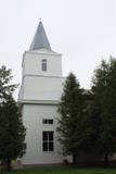 |
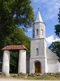
The first church was here in the early 18th century, followed by the second and third one (1847-1848), and then the one that is there now. The church was damaged during World War I and then during the Soviet era, when wool was stored there between 1969 and 1993. In the 1990s, the building was in terrible shape, but it is gradually recovering its appearance. Between 1826 and 1856, the sexton and organist at the church was the Latvian poet and translator Ansis Līventāls (1803-1878). His grave and monument are alongside the church. At the same place are the graves of German and Russian soldiers who died during World War I, as well as the grave monument of the pastor and writer Jacob Florentin Lundberg (1782-1858). |
|
 |
The farm has 50 head of cattle which spend all year outside and so can be seen at any time. Visitors can taste Highland beef and look at and ride local horses. The tours are meant primarily for adults. The owner of the farm propagandise ecological farming and breed Highland beef and local horses. |
|
 |
This exhibition has been assembled over the course of many years by its owner, Valdis Tumovs. He features war weapons, fragments of munitions, uniforms, everyday objects, military equipment such as a motorcycle, etc.
|
|
 |
The number of types of peonies in this garden is close to 400, and collect Dagnija Voika is proud of one of the largest collections in Latvia. There are 30 types of shrub peonies, and other flowers that grown there include bearded irises, Siberian irises, daylilies, as well as less common plants such as yuccas and eremurus. The garden is open in June, when the owner organises a peony festival and offers tours. The valuable peony roots are used to produce the PEO series of cosmetics, and plants can be purchased. |
|
 |
Žagare has long since been known for a special type of cherries. There are various varieties which only differ in terms of when they are ripe and productive. There are different types of trees. The cherries grow at nearly home, and that is an exclusive symbol of Žagare. |
|
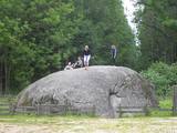 |
This territory was established to protect various kinds of rare butterflies A popular tourist destination in the Nīcgaļi forests is the great rock of Nīcgale, which is the largest rock in Latvia – a geological and geo-morphological monument of nature. The rock has a circumference of 31.1 metres, and it is 3.5 metres high, 10.5 metres long and 10.4 metres wide for a total size of 170 m3. |
|
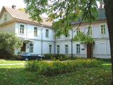 |
Veitko Manor was built in 1832. From 1993, there are hostels of
Latgale Craft School.
|
|
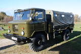 |
Edgars Kārklevalks, operator of a guesthouse Pūpoli, has a restored Soviet military GAZ-66 truck in which he offers historical and informational tours of Northern Kurzeme. The route includes former military territories.
|
|
 |
Lēdurgas dendroparks ir viens no bagātākajiem parkiem Latvijā. Parkā var iepazīt vairāk kā 1000 koku un krūmu sugas, pasugas un varietātes. Gadu gaitā Lēdurgas dendroparks kļuvis par dabas un kultūrvēsturisku aizsargājamu objektu. Piedāvājumā - skuju un lapu koki, dekoratīvie un ogu krūmi, vīteņaugi, ziemcietes, tējas augi u.c. |
|


