
| No | Name | Description |
|---|---|---|
 |
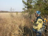
The farm is in a lovely location on the shore of a local lake. It breeds sheep, goats, rabbits and fowl. You can you on a tour, and the kids can help to feed rabbits or take a look at spring lambs. If you are interested in learning how to shear sheep, you can do so here. |
|
 |
The sauna and rest place Raudini is a place where you can rest in a comfortable quiet atmosphere, between the sea and the forest. You will be able to experience relaxation offered by a wooden-heated sauna, wisping with besoms, enjoying the sauna ritual to its fullest and drinking herbal tea. After the wisping you can cool off in the pond with water lilies and, to finish off your sauna ritual we offer chocolate or honey massages. Here it is possible to rest with your family or a small circle of friends, preparing a tasty meal on the outdoor terrace on the real wooden stove or fireplace. In the evening you will be able to watch the sunset rays in the tree spires. It is possible to use tent places outside for spending the night and wait for the sunrise near the sea. Quiet, peaceful and natural coolness. |
|
 |
This lime swamp of grasses is in an area among dunes which floods from time to time, and it is an important location for many protected plants. The swamp is easily surveyed from the forested dunes which are on the south-eastern side of the swamp. |
|
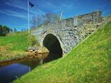 |
Takas sākums atrodas Vidagā, vietā, kur uz Vizlas celts vēsturiskais akmens arkas tilts. 1,2 km garā taka bez marķējuma ved gar pašu upes krastu līdz pat ietekai Gaujā. Redzami skaisti dolomīta atsegumi, nelieli krāčveidīgi ūdenskritumi un iespaidīgais Žākļu dižakmens. |
|
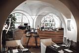 |
Situated in a building with a rich history. Historically a fish market was located here, which has influenced the activities of the restaurant. The restaurant offers a vast selection of fish dishes and seafood, as well as exquisite meat dishes. We also offer a children’s and vegetarian menu. |
|
 |
Kaziņmežs is a small area of forest to the East of the Cirste-Mazirbe road where
it intersects with the Kolka-Ventspils road. This is a fabled place. When we take the
Krustceļš route through Kaziņmežs, we arrive at the Kolka-Ventspils road (P 124).
|
|
 |
Atrodas Vecpiebalgas centrā pie Inešu ceļa. Vieta, kas jāapmeklē katram savas valsts patriotam, jo šeit atdusas leģendārā romāna "Mērnieku laiki" autori - brāļi Reinis un Matīss Kaudzītes, sabiedriskais darbinieks un valodnieks Atis Kronvalds u.c. Kapos apskatāmi brāļu Kaudzīšu un A. Kronvalda pieminekļi. Tos atrast palīdzēs izvietotās kartes un norādes. |
|
 |
Pie ceļa, kas no Bernātu ciema centra ved uz jūru, redzamas augstas ar mežu apaugušas kāpas. Uz vienas kāpas (ir norāde) novietots piemiņas akmens ar pirmā Latvijas Valsts prezidenta Jāņa Čakstes 1924. g. teiktiem vārdiem: “Te jābūt kūrortam.” Atrodas Bernātu dabas parkā. |
|
 |
One of the oldest towns in Latvia, about which data can be found already beginning from 1378. As a populated area it formed at the banks of the Tebra River (the side of Riga-Prussia road), where once the fortified wooden castle Beida of the Cours Land Bandava was located. In the medieval times Aizpute was the centre of Kurzeme bishopric. After joining Kurzeme to Russia in 1795, Jews settled for living in Aizpute. Today travellers in Aizpute are most attracted by the ancient city environment that is still alive here, as well as by the historical centre of the city and the castle ruins. |
|
 |
A third-generation family company, producing “Gotiņa” sweets since 1959. Located in the centre of Skrīveri, a 2-minute walk away from the train station. Company has a Sweets Workshop where visitors can take a tour, wrap their own candies, learn about their history, taste the products, and purchase natural and fresh sweets. For “Gotiņa” sweets with rye bread and cranberries, they use heated rye breadcrumbs from the Lāči bakery. Fresh and delicious sweets can be purchased in the factory shop.There are four different tour programmes in all. |
|
 3 days
|
No Rīgas dodieties gar Daugavas labo krastu un apciemojiet Trušu Karalisti, kurā trušu mājiņas ir veidotas kā mazas muižas un pilis. Pēc tam dodieties uz Skrīveriem nogaršot mājas saldējumu un apmeklējiet Kokneses pilsdrupas. Nākamajā dienā apmeklējiet privātu mini-zoo ar dažādiem eksotiskajiem dzīvniekiem, pēc tam dodieties uz Raunas cepli, lai redzētu, kā top dažādi māla priekšmeti no sākuma līdz beigām. Vērts apskatīt Cēsis un tās viduslaiku pili. Izstaigājiet Līgatnes dabas takas, kur iespējams redzēt vairākus vietējos savvaļas dzīvniekus. Siguldā bērniem patiks piedzīvojumu parks. Siguldā atrodas arī divas viduslaiku pilis. Pirms atgriešanās Rīgā, apciemojiet zemnieku saimniecību, lai apskatītu kazas, ponijus u.c. dzīvniekus, kā arī nogaršotu kazas piena piena produktus. |
|
 |
The estate owned by the dynasty of Baron Osten-Zaken was rebuilt in 1856 and 1857, because the old estate was sacked during the Crimean War (1853-1856). At the beginning of the war, British warships bombarded Latvia's shoreline and ships with the purpose of scaring the Russian tsar. Some of the gunfire hit Kolka, which was part of the Russian Empire at that time. After the estate was destroyed, the so-called White House was built there with a series of ancillary buildings. A mantel chimney was installed on the second floor, and it was used to smoke wild game (the chimney is still there). The estate belonged to the aristocrats until 1919, when its last owner, Christian von Osten-Zaken, was shot in Tukums. An elementary school, known as the Kolka School, was installed in the White House in 1929. It remained open until 1961, when a new school was built. Crafts lessons were offered at the building until 1989, at which time it was known as the Old School or the Small School. In 1991, the Old School was taken over by the Faculty of Biology of the University of Latvia, and it has been used for summer internships for students ever since 1994. |
|
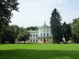 |
The Baisogalo Estate is one of the oldest ones in Lithuania and is known as a royal castle because it once belonged to the local lord. The ornate late-Classicism buildings were built in the mid-19th century and have survived. The 12 ha landscape park dates back to the early part of the 19th century, with an alley of chestnut trees leading to the estate from the local village. The central alley that starts at the gate weaves through two curvy bodies of water with a bridge and statues of lions. Various trees behind the estate are alongside curvy and narrow pathways. On both sides of the alleys are bodies of water, and deep in the park is a pond with an island. |
|
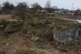 |
On the shore of the Daugava River, to the East of Lielupes Street and South-east of Jātnieku Street, there are the remnants of four battery positions that were blown up in their day. The batteries had 152-mm cannons, and this was part of the former system of fortifications in Rīga (see also Komētforts, the Daugavgrīva fortress, and the fortifications of Mangaļsala). The aim was to protect the city from invaders who came from the sea. From the top of the batteries you can see the Daugava and the northern segment of the manmade Krievu Island (a huge pile of sand). It does have to be said that the condition of this historical monument is quite pitiful.
|
|
|
|
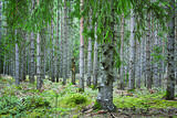
An afforested island in the Gulf of Finland, approximately 14 km to the North of Tallinn. There is a network of small roads and trails on the island. Forests: Mostly 1.1, 1.2 and 4.2. Information: www.aegna.ee. A ferry boat to the island departs from the port at Pirita. Hike around the shore of the island, where you will find all kinds of environments – dunes, sandy areas, rocky areas and places with lots of reeds (~9 km). |
|
 |
Atrodas dienvidos no Vienības nama. Skvērs veidots 19. gs. otrajā pusē. Tajā atrodas vairāki ievērības cienīgi objekti: strūklaka (20. gs. 20. gadi), latviešu tautas dzejnieka Andreja Pumpura krūšu tēls, piemiņas akmens Nevainīgajiem sarkanā terora upuriem un Sv. Aleksandra Ņevska pareizticīgo kapela. Vienības ielas otrā pusē paceļas iespaidīgā Daugavpils universitātes ēka ar Raiņa pieminekli un saules pulksteni priekšplānā. |
|
 2 days
|
Маршрут проходит по территории природного парка «Излучины Даугавы». Парк создан с целью сохранения уникальных ландшафтов древней долины Даугавы, биологического многообразия и богатейшего культурно-исторического наследия. Наибольшую высоту берега реки достигают в т.н. «Воротах Даугавы», где возвышаются Верверский и Слутишкский обрывы. С Приедайнской смотровой вышки открывается вид на древнюю долины Даугавы с высоты птичьего полета. В 2015 году в Васаргелишках и на горе Лаздукалнс были построены новые смотровые вышки. Информация о маршруте от Latvijas Lauku forums |
|
 |
Beķereja, veikals un kafejnīca atrodas Vaiņodes centrā. Saimniece cep pīrāgus, cepumus un plātsmaizes Latgales meistara mūrētā maizes krāsnī, gatavo tradicionāli latviskus ēdienus, klāj svētku galdus. Beķerejas veikalā var iegādāties ceptuves gardumus un uzzināt par apkaimes interesantākajām vietām. Par dienas aktuālo piedāvājumu beķerejas saimniece ziņo facebook.com/ineta.zveja . |
|
 |
Liepājas novada zaļā produkta, kultūrvēsturiskā mantojuma, seno lauku tradīciju saglabāšana un popularizēšana pilsētvidē. |
|
 |
Saimniecībā tiek audzēti Helix Aspersa Maxima sugas gliemeži. Ekoloģiska produkcija. Tie tiek baroti tikai ar vietējiem dārzeņiem un gliemežiem domāto īpašo barību. |
|


