
| No | Name | Description |
|---|---|---|
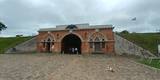 |
Found in the western part of Daugavpils and on the banks of the Daugava River, this is almost the only fortress in Northern Europe that has been preserved since the first half of the 19th century. Work on the fortress began in 1810, though it suffered much damage during the war of 1812 and because of flooding in 1829. The fortress was of strategic importance in terms of its location, not least in terms of the battle against Napoleon’s forces. It was consecrated in 1833, though construction work ended nearly half a century later, in 1878. The fort is divided up into squares, with the Parade Field in the centre of the whole fortress. After it lost its strategic importance in 1897, a warehouse was installed there. Prior to World War I, General Jānis Balodis, Colonel Frīdrihs Briedis and others served at the local garrison. In 1912, in honour of the centenary of the aforementioned war, a monument was unveiled in the park of the fortress. During the Soviet occupation, Red Army units took over the fortress, and a technical aviation school was established there. Even today, the fortress is a “city in a city.” It has a residential area, though the buildings are quite shabby. Both inside and outside the fortress are many elements that relate to military issues. Right now fundamental work is being done to reconstruct the buildings, water pipelines and streets of the fortress. The fortifications of the fortress are home to one of the largest colonies of bats in all of Latvia, and it is strictly forbidden to disturb them when they are asleep. Major restoration of the fortress has included the establishment of the Mark Rothko Art Centre. The distinguished artist was born in Daugavpils in 1903, when Latvia was still part of the Russian Empire. |
|
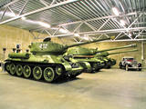 |
The Svente Baronial Estate in the Daugavpils District features a museum of military equipment, including a Josef Stalin tank, a T-34 tank, and armoured scouting vehicle, and other equipment.
|
|
 |
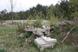
The communications facility in the forests of Bārta has been abandoned and is not being used other than for dismantling of buildings to obtain building materials.
|
|
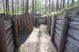 |
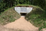
Ar Kara muzeja informatīvo atbalstu Garā kāpā pie Antiņiem ir rekonstruēta daļa latviešu strēlnieku nocietinājumu sistēmas. Aspkatāmas ierakumu pozīcijas un vairākas zemnīcas. Netālu atrodas bijusī un no dzelzsbetona veidotā medikamentu glabātuve. |
|
 |
The local museum offers an interesting and extensive exhibit related to World War II at the Kurzeme fortress and the fate of Latvian soldiers who took part in the war. There are also exhibits related to the history of World War I and World War II, complete with a collection of civilian and military objects. Among them – a YI-2 airplane, an armoured personnel carrier, a Red Army tank, and all of the trenches and bunkers of the relevant era.
|
|
 |
This testimony to World War II can be found in the Blīdene Parish. It is one of the very few objects of its type to still be in good condition.
|
|
 |
The Soviet Border Guard facility at Mērsrags was the start of the border regime zone. Absolutely nothing of the facility is left for perusal today.
|
|
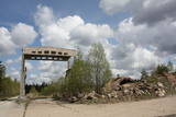 |
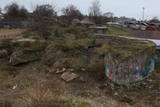
The ship and coast guard missile repair workshops in the forests around Bārta in the Liepāja District are very impressive in visual terms. The facility is owned by the regional local government and is being dismantled to obtain building materials.
|
|
 |
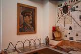
Ein am Ende des 19. Jh. gebautes Teil der Festung. Ein Museum, das Verbrechen totalitäre Regimes gegen Menschlichkeit wiederspiegelt. |
|
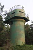 |
The battery is to the South of Ventspils, not far from the Piejūras Park. Work on the battery began in 1939. Today the site is a complete mess, standing out in a negative way from the tidy city itself. People seeking building materials and ferrous metals helped to tear the place down. It’s too bad that this historical location – one that might be of interest to tourists – is in such sad shape, and right at the gates of the city, to boot.
|
|
 |
The air defence radar facilities at the Liepāja airport in Cimdenieki are gone now, although the man-made terrain in the area remains interesting today.
|
|
 |
The former air defence missile base took up a large territory to the South of Pāvilosta in its day, but today that land has been abandoned and degraded. It can be dangerous for visitors.
|
|
 |
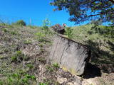
The so-called Comet Fort was built on the Left Bank of the Daugava at its mouth, not far from the present Daugavgrīva lighthouse. It was built around the same time as the other forts of Mangaļsala (around 1808, although some sources say 1788). There were four Kane-type 152-mm cannons. The defensive batteries at Komētforts and Mangaļsala repelled a British naval attack in the Daugava estuary in 1855. It has to be added that Komētforts is a cultural monument of local importance. If we go along the shore of the sea from the Daugavgrīva nature reserve toward the Daugavgrīva lighthouse and scale the frontal dunes (without going past the sign which says “Closed Territory. Border Zone.”), then we can see the positions of the cannons, as well as underground cellars where munitions were once stored. The territory starts approximately 500 metres before the Daugavgrīva lighthouse and stretches to the lighthouse itself. During Soviet times, the territory was closed to civilians, because many secret military objects were in this area and in Bolderāja.
|
|
 |
On the shore of the Daugava River, to the East of Lielupes Street and South-east of Jātnieku Street, there are the remnants of four battery positions that were blown up in their day. The batteries had 152-mm cannons, and this was part of the former system of fortifications in Rīga (see also Komētforts, the Daugavgrīva fortress, and the fortifications of Mangaļsala). The aim was to protect the city from invaders who came from the sea. From the top of the batteries you can see the Daugava and the northern segment of the manmade Krievu Island (a huge pile of sand). It does have to be said that the condition of this historical monument is quite pitiful.
|
|
 |
The former Soviet-era fuel base was part of the military facilities at that time. Fuel tanks from this site have been removed and no longer exist. |
|
 |
These are the ruins of World War II fortifications near what is now the Ķegums hydroelectric power plant. One blockhouse was found on the left bank of the Daugava River, approximately one kilometre to the South-Southeast from the plant’s dam. A second is also on the left bank of the river, opposite the Rēzijas campground. It has slid down the abraded shore of the reservoir and is partly underwater. It is mostly accessible by boat.
|
|
 |
This is a closed and guarded territory on the banks of Lake Būšnieks in Staldzene. The former project building is on the shore of the sea.
|
|
 |
Nordeķu - Kalnciema kāpu grēdas daļa Kleistu meža austrumdaļā pie Dzirciema ielas. Padomju laikā šeit darbojās divi (vēlāk viens) P - 35 radars, kas griezās ap savu asi. Vietējie iedzīvotāji tolaik šo vietu bija iesaukuši par "Lokatoru kalniņu". Ziemeļos no tā atradās padomju armijas cūku ferma. |
|
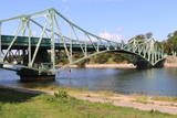 |
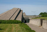
The bridge was built in 1906. Part of it was blown up during World War I and later restored. During the Soviet occupation, one needed special permits to cross the bridge. Military ships and other vessels used the canal, because one of the largest military bases in the USSR was sited here. In the summer of 2006, one month before the bridge’s centenary, a Georgian-flagged tanker, the Anna, rammed into the northern support structure of the bridge, and that destroyed the bridge’s turning part beyond recognition. The bridge was renovated and reopened in 2009. You can look at the bridge and cross it at any time.This is a unique engineering monument, and it is the only drawbridge of its kind in the Baltic States. It takes just five minutes to turn the two parts of the bridge.
|
|
 |
The Cape of Kolka is freely accessible to local residents and tourists today, but the border guard facility still serves its purposes and is not open to civilians.
|
|
