
| No | Name | Description |
|---|---|---|
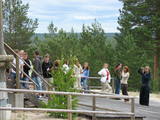 |
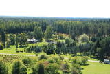
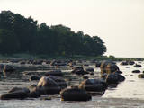
In Estonian, Luitemaa means ‘the land of dunes’. It is the seashore territory of the Gulf of Pärnu, 13 km between Vöiste and Häädemeeste with shallow waters, vast coastal meadows, the highest dune range in Estonia and the Tolkuse Mire (Tolkuse raba). The Tolkuse mire trail (~2.2 km) and watching tower are available for dune and mire sightseeing tours. Situated in Luitemaa Nature Reserve. |
|
 |
Ein schönes Holzhaus (Baznīcas ielā 7), gebaut 1670 an der sogenannten Venedig-Brücke in Kuldīga über den Fluss Alekšupīte. Auf dem Dach des Hauses befindet sich eine der ältesten und schönsten Windfahnen der Stadt. |
|
 |
The farm offers a look at angora rabbits, which are very uncommon in Latvia. The owner offers tours, stories, rabbit wool, wool products such as mittens and socks, breeding rabbits and consultations. Children will love the animals and can feed them in the presence of the owner. |
|
 |
Cecīļu dabas taka ir kājāmgājēju tūrisma maršruts, kurā ir iespēja iepazīt Amatas novada dabas objektus gar Kumadas upes, Dančupītes un Amatas upes krastu. Takas sākuma punkts ir Amatas novada Ieriķos, 1 km no kafejnīcas, degvielas uzpildes stacijas, Cecīļu dabas takas apmeklētāju centra, blakus autoservisam. Apmeklētājiem ir iespēja izbaudīt cilvēka nepārveidotu dabas ainavu – Dančupītes kanjonu, minatūru ūdenskritumu, no Kumadas upes labā krasta aplūkot iespaidīgo Cecīļu iezi un citus objektus. Taka ir marķēta. |
|
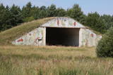 |
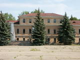
There are still some buildings, missile silos and an apartment building from the old No. 158 Zenith Missile Base at Ziemupe, but the territory has been abandoned and degraded.
|
|
 |
This arboretum is in a lovely location in the Vidzeme highlands. It covers 140 hectares of land and offers a look at interesting coniferous trees, lianas, lilacs, rhododendrons and peonies. The facility has a modern visitor information centres.
Unique species: The Tulip Tree (Liriodendron tulipifera), the Fringe Tree (Chionanthus virginicus), and the Kobushi Magnolia (Magnolia kobus).
|
|
 |
The farmyard offers to see the domestic animals, birds and exotic maras as well as horse-back riding on a pony. You can get a consultation about gardening and breeding small animals. It is possible to buy quail eggs, smoked meats, chicken and birdlings. |
|
 |
В давние времена проспект Курмаяс был главной дорогой, ведущей на пляж. Вдоль проспекта стоят роскошные дома и виллы рубежа XIX – XX века, принадлежащие аристократам – обожателям моря и побережья. Здесь установлены отлитые в бронзе скульптуры из гимна Лиепаи «Город, в котором рождается ветер» - «Лодочник», «Янтарные латыши», «Ворона» и др. В конце проспекта возвышается памятник погибшим морякам и рыбакам (установлен в 1977 г.). Он символизирует женщину, которая ждет возвращения домой своего мужчины. На проспекте Курмаяс 16/18 находится Лиепайский историко-художественный музей. Музейный фонд (всего более 100 000 экспонатов)разместился в построенном в 1901 году в стиле эклектизма (с элементами готики) доме, который строился по эскизам берлинского архитектора Эрнеста фон Ине и проекту П. М. Берчи. В экспозиции представлена каменная стела – единственная подобного рода находка в странах Балтии с могильника под Гробиней (могильник Скандинавов). |
|
 |
The national park was established to protect the 100 or so small islands that make up the archipelago of the local area. The largest island, the Vilsandi Island, is 6 km long and up to 2 km wide. You can rent a boat to get there, or, during appropriate conditions, you can walk across the sea and the small islands from the southern end of the Kuusnõmme peninsula.
|
|
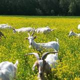 |
The farm breeds dairy and meat goats. They make yogurt, cheeses from the goat milk. They also make ecological organic goat's milk soap. In the farm they also grow rhubarb and make syrups and juices from it. You can take a tour, view the animals, taste milk, yogurt, various cheeses, meats sausages, etc.) and purchase the products, as well. |
|
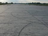 |
The Rumbula airfield was originally a military facility, established after World War II at a place where many single family farms had been before. When the Spilve airfield shut down, civilian aircraft moved to Rumbula, while military aircraft were based at the Rīga airport. Today the world “Rumbula” is most often associated with the automobile and spare parts market that has been established on part of the former airport’s territory. A certain “heritage” at the site is pollution from the former airfield’s fuel containers, where petroleum was stored. Paragliding occurs at the airfield.
|
|
 |
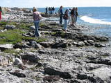
Back when the Baltic Sea was part of the ancient Littorina Sea, the coastline emerged as a small and shallow shore that was formed 4,500 to 5,000 years ago. The coastline has little rocks and gravel that have preserved typical examples of fauna from the Littorina Sea. The ancient cliff is best seen at the Dobeļi homestead in Kaltene. This is one of a few parts of the shore of the Bay of Rīga where there was an abrasion coastline during the era of the Littorina Sea. The shallow bay is popular among birds which feed and rest here during migrations. (Source: Roja TIC) |
|
 |
Holiday house Ugaraja Kotkaapesa is a cosy place where the owners offer homemade dishes to their guests from ingredients grown locally. The holiday house has a large lounge and sauna, and the area is suitable for hiking. |
|
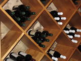 |
In the 400-year old manor’s cellars (possibly the oldest in Latvia) one is offered to taste the home-made wines produced in Kurzeme (3-7 different wines), as well as the special wine of Shlokenbeka manor with the indigenous countryside goods (you are promised a suprise!) |
|
 |
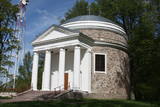
Atrodas Daugavas prospektā 10, starp Rīgas – Daugavpils šoseju (A 6) un Kalēju ielu. Dievnams celts laikā no 1931. - 1933. g. (arhitekts: Pēteris Kundziņš). Padomju gados tajā bija izvietota Latvijas Valsts bibliotēkas grāmatu glabātava. Pateicoties draudzes aktivitātēm 1989. g., ēku atjaunoja. Tagad tā kalpo savam pamatmērķim. |
|
 |
1275 is considered as a year of foundation of Daugavpils. This is the time when the Master of Livonian Order Ernst von Ratceburgs built Dinaburg castle at the Naujene hill fort. It suffered several Lithuanian and Russian invasion until in 1577 the castle was destroyed by Russian troops under the command of Ivan the Terrible. After this event Dinaburg was restored 17 km further on the right bank of the river, where now the town of Daugavpils is located. From 1810-1833a new fortress was built. In 1826 started the building of what is now the historic centre of the town. During the World War I the major industrial companies with workers were evacuated to Russia. During first Latvian Republic, the cultural life in Daugavpils flourished. Most part of the town was destroyed during World War II – in the July of 1944. Nowadays the town is the second largest town in Latvia and is an important economical centre of Latgale historic region. Restoration of Daugavpils Fortress was launched recently; this project can be considered as a unique on the European scale. |
|
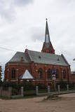 |
Atrodas t.s. Baznīcu kalnā – 18. novembra ielā 66. Apjoma ziņā – lielākais Daugavpils luterāņu dievnams, kuru cēla laikā no 1891. - 1893. g. neogotiskā stilā no sarkanajiem ķieģeļiem (arhitekts Vilhelms Neimanis). 1941. g. baznīcā izcēlās ugunsgrēks un gāja bojā lielākā daļa no tās sākotnējās iekārtas. Turpmāko divu gadu laikā baznīcu daļēji atjaunoja, taču vēlāk tajā izveidoja noliktavu u.c. baznīcai „nepiederīgas” iestādes. 1985. g. ēka vēlreiz cieta ugunsgrēkā. Pagājušā gadsimta deviņdesmito gadu sākumā uzsāka baznīcas atjaunošanas darbus, uzstādīja solus un altāri, kas ir Ogres Amatniecības vidusskolas audzēkņu darinājums. |
|
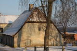 |
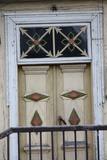
This little building is on the left bank of the Venta River beyond the ancient brick bridge. It is located at Pils Street 4. The hut was built in 1735, using rocks from the damaged castle of the duke, and it was built on a terrace that is the last fragment of the walls that surrounded the castle. Also known as the Hangman’s hut, the building was rebuilt during the 19th century. It can only be viewed from the outside. |
|
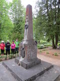 |
Near Karva along the old Alūksne-Ape road, the monument was unveiled on November 12, 1937. It was designed by the architect Verners Vitands and contains the text “Soldiers from the Valmiera Brigade who fell during Latvia’s liberation battles in 1919; I rested my head on the moss and defended my fatherland.” The monument was torn down in 1975 and restored in 1944. |
|
 |
In the 15th century, Preili manor became the property of Count Borhs family. Borhs were living here until the 60ties of 19th century. The city itself formed in the first half of the 19th century by fusion of Preili Manor, the village and free village - settlement of traders and craftsman. In the 19th century a luxurious palace was built in Preili and Landscape Park was created. Today Preili is an important economic centre of Latgale (cheese and sewing plants), where t folklore, crafts and Catholicism traditions are fostered. Preili tour in the guidance of TIC employee Irena Kjarkuza is highly recommended. |
|


