
| No | Name | Description |
|---|---|---|
 |
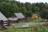
Darbnīcā tiek izgatavoti personalizēti pulksteņi un dažādi dizaina priekšmeti no koka, kā arī piedāvātas kokapstrādes meistarklases vai klātbūšana dažādos materiāla pirmsapstrādes vai finiša apstrādes procesos. Tāpat iespējama ekskursija pa darbnīcu un koku sugu atpazīšanas viktorīna. |
|
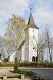 |
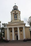
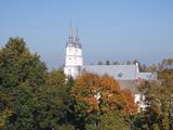
The Priekule Lutheran Church was built around 1680 and rebuilt a century later, in 1892. In 2005, the church tower was improved, and visitors to the church can now use it as a viewing platform. They can see the place where Icarus of Priekule supposedly made his first “flight.” |
|
 |
Ezeres kultūrvēstures un novadpētniecības materiālu krātuve “Muitas nams” ir izveidota vēsturiski nozīmīgā ēkā, kur, II pasaules kara noslēgumam tuvojoties, 1945. gada 8. maijā tika parakstīts Kurzemes katlā ielenkto vācu karaspēka daļu kapitulācijas akts. Ar to tiek uzskatīts, ka Ezerē faktiski beidzies II pasaules karš. Krātuves materiālu ekspozīcijas ir no Ezeres pagasta senvēstures līdz šodienai, tai skaitā ezernieku vaļasprieki. |
|
 |
This is an ancient populated area. There were 50 homesteads here during the 1930s, with only ten remaining in 1990. The Livonian scholar and entomologist Kārlis Princis (1893-1978) was born in Oviši. In 1944, he emigrated to Sweden. The Oviši lighthouse (1814) is 38 metres high and is the oldest functioning lighthouse in Latvia. There are lovely views from the top of the lighthouse. The building in which employees of the lighthouse used to live was erected in 1905 and has been preserved. A narrow-gauge train station was in the building at one time. The Oviši Lighthouse Museum is nearby, as is the metal Tree of Austra. Opposite Cape Oviši is a great place for bird watching. |
|
 |
The House-Museum of the writer Michael Narics. Reveal the history of political repressions in the
USSR and Soviet Latvia; see creative works of the winners of competition organized by M. Narics Educational
Center.
Working hours: on request |
|
 |
Black currants are grown on 3 ha of land at Bānīši, and for several years the owner has used the method that is so popular abroad -- allowing people to visit the farm to pick all of the berries that they need. |
|
 |
Divus kilometrus garās lokveida takas sākums ir meklējams pie Somā nacionālā parka apmeklētāju centra (atklāts 2000. gadā) – Tēramā ciemā. Tā ved gar Mardu strauta (Mardu oja) krastu, kur krustām šķērsām ir sakrituši bebru nogāztie koki, radot diezgan juceklīgu skatu. Apmeklētāju centrā var iegūt nepieciešamo informāciju, noskatīties videofilmu un nacionālajam parkam veltītu ekspozīciju. |
|
 |
Grūti iedomāties, ka vēl joprojām Eiropā ir apdzīvotas vietas, kuru sasniegšanai ir labu laika sprīdi jābrauc pa neapdzīvotu mežu ieskautu smilšainu ceļu, kur tikai paretam var redzēt kādu sēņotāju vai ogotāju! Tāpat kā Zervinos ciemam, arī šim ir piešķirts kultūras mantojuma pieminekļa statuss, jo Linežeris ir viens no dažiem nacionālā parka etnogrāfiskajiem ciemiem. Linežerī ir aplūkojamas 19. – 20. gs. mijā celtās ēkas un apskatāms tā laika ciema plānojums. Šejieniešu tāpat kā citu dzūku galvenā nodarbošanās bija mežistrāde un meža velšu vākšana. Nelielā mērā – arī lauksaimniecība. Apceļojot nacionālā parka etnogrāfiskos ciemus, rodas pamatots jautājums: „Ar ko mūsdienās te nodarbojas cilvēki. Kā viņi spēj dzīvot tik nomaļā vietā”? Jāatzīst, ka lielākā daļa te ierodas tikai vasaras laikā. Neskatoties uz to, etnogrāfiskie ciemi ir ļoti sakopti un joprojām „dzīvi”! |
|
 |
This is a new café in Naujene, which is part of the “Curves of Daugava” nature park. |
|
 |
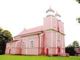
Lai arī dievnama pirmsākumi meklējami 18. gs. sākumā, tā celtniecību (arhitekts Johanns Eduards de Vite) pabeidza viena gada laikā 1834. – 1835. g. (vēlīnā klasicisma stils). Būvniecības darbus finansēja Krievijas cars. Gan baznīcas atrašanās piejūrā, gan arī tās nosaukums liecina, ka tā celta, godinot Svēto Nikolaju, kas ir visu jūrnieku un zvejnieku aizbildnis. Baznīca apskatāma arī no iekšpuses, kur uzmanība jāpievērš ērģelēm un altārgleznai (1888. g.). |
|
 |
This is an area where migrating birds seek shelter and food all around the year. Seen most often here are the red-throated and black-throated loon, the common shelduck, the long-tailed duck, the velvet scoter and the little gull. The territory is also important for the protection of reefs. It lies opposite the Dundaga, Roja and Engure administrative districts, as well as the city of Jūrmala, and it covers 132,173 hectares of territory. The marine parts of the Engure Nature Park and the Ķemeri National Park are covered.
|
|
 |
The owners of Tahku coastal houses organise cucumber marinating and salting workshops with a happy mood. Cucumber festival Tahkuranna takes place every year on 20 August, and there you can buy canned cucumbers, local food and handicrafts, participate in master classes, and also make handicrafts. |
|
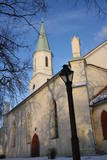 |
The first wooden church was built here in 1252, and the brick church was built in 1665. It burned down and was restored in 1672, but it was rebuilt in later years. There are important artistic monuments in the interior of the church – the altar, the pulpit and the painted organ. Legendary Duke Jacob Kettler of Courland (1610-1682) was baptised in the church and married Princess Charlotte Louise from Brandenburg in it. During the Soviet era, the church housed a museum and a concert hall. According to legend, the name of the church is based on a woman called Catherine, who donated funds to build the church, was subjected to lies, tortured and then proclaimed as a saint. Above the side entrance is a medallion of a woman with a crown of thorns, torture equipment and a sword in her hand. Elements of this story can also be seen in the herald of Kuldīga. The steeple of the church offers a good look at the roofs of the ancient part of the city. |
|
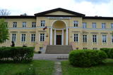 |
Tāšu – Padures muiža (Tasch – Paddern) celta 19. gs. sākumā kā Korfu dzimtas pils, kas 1852. gadā pāriet Keizerlingu dzimtas īpašumā kā medību pils, kas kalpojusi kā vasaras mītne, un ir izcils vēlīnā klasicisma paraugs. Iekštelpās saglabājušies vairāki senā interjera apdares fragmenti. Pēc pils pabeigšanas, ap to sāka veidot vairāk kā 10 ha lielu parku ar svešzemju kokiem. Šobrīd muižas ēkā atrodas Kalvenes pamatskola. |
|
|
|
Uzcelts Kaņiera pilskalnā un ir Kaņiera pilskalna takas sastāvdaļa. No torņa paveras izcila Kaņiera ezera dienvidrietumu daļas ainava ar niedru saliņām un nelieliem atklāta ūdens laukumiem. Laba putnu vērošanas vieta. |
|
 |
The farmstead grows apples, strawberries, black currants, red currants, etc., berries and fruits; there is a big selection of processed goods: natural juices, nectars and syrups. There are offered apple, strawberry, red currant, gooseberry, sea-buckthorn and chokeberry saplings; consultations are given for making out a commercial garden and taking care of it. Excursions around the commercially grown plants. |
|
 |
St. Michael the Archangel Roman Catholic Church of Viļāni. The Church together with the Monastery
of Bernardian Order was built in the middle of the 18th century. It is a national cultural monument. Many
important paintings, sculptures and objects of applied arts have survived here. The Church has an organ and
a fisharmony. The status of national importance was awarded to the architectural monument in 1952.
|
|
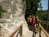 |
In terms of shape, this is one of the most diverse areas of uncovered sandstone in Latvia. Found on the right bank of the Gauja river, the Sietiņiezis is up to 15m high. Small holes that can be seen in the cliff face are created by single and protected insects, which carve tiny caves in the cliff for their caterpillars. A circular and well appointed trail, with stairs, has been installed. It is 1.5 km in length and will take an hour or so to traverse. Objects are in the Gauja National Park.
|
|
 |
Located in the southern part of Feimaņi, the church was built between 1756 and 1760. The local estate was owned by the Korff dynasty, and the denomination of the congregation changed when the family converted from Lutheranism to Catholicism. This church has the largest number of artistic monuments among all churches in the Rēzekne Administrative District, including a confessional bench, pews, an organ prospectus, silver cups and three altar wood engravings from the 18th century. Above the gate is a bell tower with four bells. During Holy Week, clappers are used instead of bells. They are about 2 m long and 1 m high and are reminiscent of ancient laundry rolls. Feimaņi is also home to one of three flag workshops in Latvia, and it has state-of-the-art equipment. The flag of Latgale was “born” here in ideological and physical terms. |
|
 |
Atrodas Valmieras – Ainažu autoceļa (P 16) malā starp Matīšiem un Aloju. Iekārtota vecajā un atjaunotajā dzirnavu ēkā. Nedēļas nogalēs piedāvā izklaides pasākumus, klāj galdus un īrē telpas svinībām. |
|


