
| No | Name | Description |
|---|---|---|
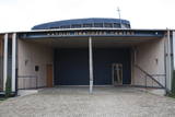 |
Atrodas Ganību ielā 120. Celta (iesvētīta 2001. g.) mūsdienu modernās arhitektūras formās un interesanta ar faktu, ka sākotnēji bijusi Vatikāna paviljons Pasaules izstādē “Expo 2000” Hannoverē. To pārbūvēja un uz Liepāju pārcēla par Vācijas katoļu saziedotajiem līdzekļiem. Ēkā darbojas katoļu draudzes centrs. |
|
 |
Lots of wild animals can be found in vast paddocks along the ancient Gauja river valley and its small tributaries – areas in which living conditions are as close to natural circumstances as possible. Here the visitor can find, if lucky, reindeer, deer, wild boars, bears, foxes, lynx, various kinds of birds, as well as aurochs. There is a dense network of pathways in the park, including lots of information. There is also a route for drivers and bicyclists. During the winter, it is used for distance skiing. There is also a visitors’ centre.
|
|
 |
Līga Reitere is a ventiņi story teller and a specialist in herbs, and in an old school classroom, she teaches penmanship and the ventiņi dialect. An informational tour is available, and visitors can purchase products and souvenirs from Kurzeme. |
|
 |
Ismeri Old-Believers Prayer House was built in 1912 by the donations of local people. The parish of
Ismeri exists since 1861.
|
|
|
|
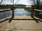
The viewing tower is on the western part of the Blue Hills of Ogre, not far from the Dubkalni quarry. Paths lead to the tower, as does a wooden staircase. The viewing platform offers a very broad view of the Ķegums hydroelectric power plant reservoir and the towers of
|
|
 |
Sääniku farm recreation centre is located on the banks of the Kavilda former river course, and is a great place to spend free time with the family, enjoying activities and nature. You can taste the house beer, home-made bread and order meals here. |
|
 |
Iespēja atpūsties un relaksēties pirtiņā, baudot latviskos pirts rituālus. Sildīšanās un pēršanās ar pirtsslotām, augu skrubji un maskas, kāju vanniņas un zāļu tējas. Pēc pēriena – veldze dīķī. Pirts tā ir svētnīca miesai, garam un dvēselei. Piedāvājumā arī izglītojošā programma par augu spēku un to izmantošanu savai labsajūtai. Apmeklējums noteikti iepriekš jāpiesaka! Vietu skaits ierobežots! |
|
 |
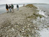
Pļaviņās, pie Daugavas ielas, Daugavas krastā uz laukakmeņiem novietots plosta modelis ar stendu (2011. gads, biedrība „Kopsolis”), kur izlasāms stāsts ar plostnieka atmiņām un aplūkojamas vēsturiskās plostnieku fotogrāfijas. Daugavas posms starp Pļaviņām un Koknesi bija visgrūtāk pārvaramais plostnieku šķērslis ar krācēm un līdz 20 m augstiem, klinšainiem upes krastiem. |
|
 |
The saloon is opposite the Machinery Museum on the edge of Bauska. The nationally historical interior allows visitors to comfortably feel different than others. Latvian cuisine: Oatmeal, milk soup, pumpkin soup, cold beet soup, homemade steak haché, potato pancakes, crepes, bread soup. |
|
 |
Because this circular trail is in a nature zone, it may only be traversed in the company of a guide from the Slītere Nature Park. A steep stairway that has been installed along the ancient shores of what was once a Baltic lake of ice will lead the visitor to a completely different world, one with fallen trees, broadleaf forests, an area in which underground streams create aboveground wetlands, a limy and grassy swamp (all of these are protected areas), remains of old-time reclamation ditches, and rotting fir stumps which are important in terms of the diversity of species and which have been in the region since a major windstorm in 1969. The trail is 1.2 km long and will take an hour to an hour-and-a-half to traverse. The trail begins at the Slītere lighthouse, where the SNP visitors’ centre is located (in tourist season).
|
|
 |
Laivošanas pasākumu organizēšana, kajaku, kanoe laivu, SUP dēļu un aprīkojuma īre un pārdošana. |
|
 |
The restaurant is at the Chocolate Museum in Pūre. The terrace offers a lovely view of the ancient Abava River valley. The men changes on the basis of the seasons and demand. Latvian cuisine: Chilled soup, sorrel soup, sautéed peas and carrots, liver stroganoff, oatmeal dessert, milk gelatine with berry sauce. Special foods: Dishes with Pure Chocolate products and garnishes. |
|
 |
The Kassari Island is the fifth largest Estonian island, and it is found to the South of the Hiiumaa Island. There are two dams between the two islands, and a road for motor vehicles has been installed atop them.
|
|
 |
You will find the nice and quiet Kuusiku Nature Farm on the edge of the beautiful Lahemaa National Park by Lake Viitna Pikkjärv. The Kuusiku Farm offers traditional farm bread. |
|
 |
Established in 1957, this is the first company to have produced the popular milk candies “Gotiņa.” The tasty candy can be bought, and tours are available. The owner of the company is the main candy master, and he is happy to talk about the complicated method by which the candy is produced.
|
|
 |
The former Soviet-era fuel base was part of the military facilities at that time. Fuel tanks from this site have been removed and no longer exist. |
|
 |
The Mežotne castle hill is on the left bank of the Lielupe River and opposite the Mežotne Castle. This was one of the largest Semigalian fortified castle hills during the 9th to the 13th century, and an ancient town alongside the hill covered 13 ha of land. The castle hill has been improved. A pontoon bridge across the Lielupe allows hikers and bikers to reach the castle (between May and October). Vīna Hill is approximately 500 m to the South of the castle hill, and a wooden pathway leads to it. |
|
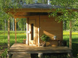 |
Sauna Museum is a private open-air museum founded in 2008. It is located 40 km from Riga by the Murjāņi - Saulkrasti road. The exhibition consists of six historic and one newly built sauna. They all work, but the hosts recommend to enjoy the black sauna. |
|
 |
The cafe Picerija is situated in Lielvarde alongside Riga-Daugavpils highway. |
|
 |
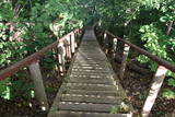
1,7 km gara lokveida taka, kas iepazīstina ar dažādiem meža biotopiem, to iemītniekiem un meža apsaimniekošanas pamatprincipiem. Apmeklētāju ērtības nolūkā ir izveidotas koka laipas un neliels skatu tornis. |
|


