
| No | Name | Description |
|---|---|---|
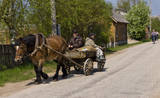 |
Old Believers, who fled persecution from the Russian Orthodox church because of their refusal to adapt to church reforms, settled down on the western shore of Lake Peipsi in the 17th and 18th centuries. |
|
 |
In the central part of the Žemaitija Highland, this park was established to protect local landscapes. Lithuania’s highest hillocks are found here – Mėdvegalis (235 m above sea level) and Šatrija (229 m). There are also other hillocks which offer a great view of the area – make up your own tour here.
|
|
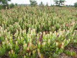 |
Large cranberries were first grown in the Laugas Swamp in Latvia in 1992. Today there are six types of cranberries that were originated in Latvia. Among them is a hybrid between large American cranberries and Latvian cowberries, and it is known as the noble cranberry. You can attend lectures, receive consultations, tour the swamp, and purchase cranberries, cranberry products, as well as purchase turf that is needed to grow your own cranberries. |
|
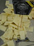 |
The Limbažu Cheese factory has more than 90 years of experience with dairy processing. It only uses milk from local farmers in Vidzeme, while the dairy processing technologies have been brought in from Switzerland. Limbažu Cheese exports 95% of its output. Alongside the company and on the other side of the street from the ruins of the Limbaži castle is a little store where the company’s products can be bought. |
|
 |
Piedāvā ļoti gardus Lietuviešu tradicionālos ēdienus. Var pieņemt līdz 80 personām. Pieņem bankas kartes, ir āra terase un dzīvā mūzika. Pieejama autostāvvieta. |
|
 3 days
|
This part of the Forest Trail gives an opportunity to see Setomaa or “the Land of Setos” which is inhabited by Setos – an ethnographic group with specific ancient traditions and a unique language dialect. Forest Trail hikers can visit the traditional Setos homestead and enjoy Setos cuisine. The forests of the region are especially charming in early autumn, when the ground is coloured lilac by the blooming heather. There is a good chance to pick wild mushrooms and berries. One of the most beautiful sections of this trail in Setomaa leads along the River Piusa, where the river is surrounded by sandstone outcrops. You will also visit the Piusa caves. The tour will end in Värska resort – with its sanatorium and SPA, which use the strengths of local nature: mineral water and lake mud. Värska mineral water is well known in Estonia and elsewhere. |
|
 |
Sääniku farm recreation centre is located on the banks of the Kavilda former river course, and is a great place to spend free time with the family, enjoying activities and nature. You can taste the house beer, home-made bread and order meals here. |
|
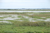 |
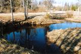
The Lake Lubāns, wetland of Lubāns. Lubāns (80.7 km2) is the largest lake in Latvia and the most popular
lake and wetland in Europe. The lake and the wetland has biodiversity; a unique place not only in Latvia,
but also internationally. Nature Reserve is included in the European Union network of protected areas and
NATURA 2000 under the Ramsar Convention criteria as the wetland of international importance. Lubāns wetland,
called marshy meadows, includes bogs, wet meadows and wet forests. In autumn and spring the lake
attracts thousands of migratory waterfowl which is easily to wach from the bird observation towers or the terrace
of water tourism development center.
|
|
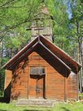 |
Krupenišku Old-Believer Prayer House was built in 1908. The autor of the
design is engineer I. Ivanov. At present the church is in bad tehnical condition.
|
|
 |
Take a tour of this lovely plant farm, which has more than 3,000 types of plants, including a wide range of water plants. You can purchase plants and receive consultations on growing them. |
|
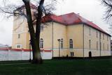 |
The Castle of the Livonian Order in Ventspils was first listed in documents in the late 13th century, and despite damaging wars, it has maintained its essence as a castle to this very day and only with minimal changes. The castle is also known as the oldest Medieval fortress in Latvia. Today it is home to a modern museum. |
|
 2 days
|
Маршрут проходит по территории природного парка «Излучины Даугавы». Парк создан с целью сохранения уникальных ландшафтов древней долины Даугавы, биологического многообразия и богатейшего культурно-исторического наследия. Наибольшую высоту берега реки достигают в т.н. «Воротах Даугавы», где возвышаются Верверский и Слутишкский обрывы. С Приедайнской смотровой вышки открывается вид на древнюю долины Даугавы с высоты птичьего полета. В 2015 году в Васаргелишках и на горе Лаздукалнс были построены новые смотровые вышки. Информация о маршруте от Latvijas Lauku forums |
|
 2 days
|
The Baltic Coastal Hiking Route goes through Nõva Nature reserve where you will have exceptional views of the white and grey dunes. The beaches are popular for fishing and kite-surfing. In Dirhami you can spend some time in a cafe and from its terrace you will have a beautiful view of the sea and the port. Along the way you can also see ancient Swedish hamlets with a different cultural environment and landscape, as well as shallow lakes that have been separated from the sea. |
|
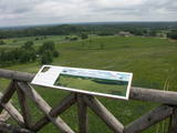 |
This park is in a region of hillocks in the Karula highlands, and Lake Ähijärve is at its centre. The park offers a cultural environment of small farms, and it was set up to protect the unique cupola-shaped hillocks of the area. Main attractions: Scenic Lake Ähijärv (176ha), Rebasemõisa Tornimägi hill (137.8 m above sea level), undulating landscapes. |
|
 9 days
|
This tour offers visiting UNESCO World Heritage sites – Helsinki, Stockholm, Riga, Tallinn, travelling by ferries and cruise ships and adding value to the trip by exploring the Baltic countries beyond the capitals. The sites outside cities present traditional folk cultures of Finland, Sweden, Estonia and Latvia and a variety of farms showing today’s life in the countryside. The roundtrip includes two overnights on cruise ships. |
|
 |
One of the largest karst areas in Estonia is found here. The unique Witch’s well is one of the most interesting parts of this area. During spring floods (not every year, and for only a short period of time), the well erupts with underground river waters to create an unusually powerful karst stream that can pump out as much as 100 litres per hour.
|
|
 2 days
|
The first part of this section of the Forest Trail winds along the magnificent River Piusa valley, then, at Härmä Village, it turns towards Obinitsa, an important cultural centre of Setomaa, the Land of Setos. Here you can discover the traditions of the local Seto people, for example the fine handicraft of the Seto women. After Obinitsa, the Forest Trail leads through beautiful pine forests rich in heather, descends back into the depths of the River Piusa valley and ends at the Piusa caves. The Piusa sandstone caves are the result of hand-mining glass sand from 1922-1966. The biggest wintering colony of bats in Eastern Europe is located in the caves. When accompanied by the guide, you can visit the observation platform at the Museum cave. |
|
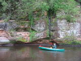 |
The Brasla River flows through a lovely valley that is approximately 300 m wide and up to 30 m deep. It is near the Inčukalns-Valka highway. The river has among the most beautiful rapids in the country, with mighty cliffs (the Brasla cliffs) that can be seen at nearly every curve in the river (except along the lowest reaches of the river). During the winter, various unusual frozen waterfalls can be seen in some of the cliffs, including the Krauļukalns cliff and the Jāņavārti cliff. On the left bank of the Brasla, opposite the Brasla fish farm, there are the Aņīte cliffs -- a series of sandstone cliffs that are 1 km long. The cliffs are between 2 and 35 m in height, and the sandstone cliffs are separated by ravines. On the right bank of the Brasla, there are major cliffs such as the Vāršavu cliff, the Kraukļukalns cliff, the Jāņavārti cliff, the Slūnu cliff, the Virtaka cliff and the Buļi cliff. How can you best learn about them? Boat down the river from the aforementioned highway or even from Straupe, which is further upstream. An alternative is hiking down the right bank of the river, though please take into account that the terrain is fairly extreme, and you are going to have to think about what to do when you arrive at the place where the Brasla River flows into the Gauja. |
|
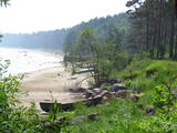 |
There are both sandy beaches with a good infrastructure and a rock beach in Roja. The rocky beach leads to a huge rock that is 2 m high and 12.5 m in diameter. The coastline is lovely with its scattered stones and its unhurried rhythm of time. At the place where the Silupīte River flows into the sea there are remnants of ancient wooden boats and iron nails. In 1939, Roja became the starting point for a closed zone, because the Soviet army and navy were sited there until 1993. The dunes at Krasta Street feature Soviet heritage, including a large cement wall from which border guards used to monitor the sea and catch those who violated the border. Behind the dunes was a base for border guards with everything they needed. Roja housed a Border Guard post and an air defence radio locator. (Source: Roja TIC) |
|
 |
Višķi is a populated area that started as the Višķi Estate and received the status of a village in the 19th century. An agricultural school was opened there in 1921, followed by a one-year homemaking school in 1926. During World War II, in 1943, the Višķi Gardening and Beekeeping School was established. After the war, the Višķi Gardening (later Agricultural) Technical School was opened. Because of these educational activities, Višķi ir not similar to a typical countryside village. There is a wide area of lovely plants, including a dendrological park (est. 1936) and apple orchards. A local guide will tell you all about the park, but you can also stroll through the village individually. |
|


