
| No | Name | Description |
|---|---|---|
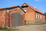 |
Found on the right bank of the Saka River at Dzintaru Street 1, the museum is in the first red brick and fieldstone building in Pāvilosta. It was built in 1879 for ship pilots. The museum focuses on the history of the local region, particularly in terms of fishing and seafaring. Among the exhibits are stone and bone axes, bronze brooches and belts, as well as a unique honey press, all of which have been found in the Saka Parish. Alongside the museum is a boathouse with larger exhibits. A mansard that was opened in 2012 is a site for exhibitions and thematic events. The museum’s phone number is +371-6349-8276. Make sure that you also visit the oldest part of Pāvilosta – Āķgals, which is a typical coastline village from the 19th and early 20th century. |
|
 3 days
|
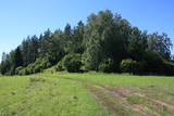
This is the most challenging Forest Trail section, especially on the second day. Here, on the coast of the Gulf of Finland, rises the North-Estonian Klint – a steep, rocky and forest-covered cliff that stretches non-continuously to Tallinn and further to the islands of West-Estonia. The Forest Trail runs on top of the cliff and occasionally descends into valleys. It crosses the deep and vast Pühajõgi valley in Toila-Oru park and comes to Toila, a popular coastal resort. One of the most unusual sections of the Forest Trail in Northern Estonia, which leads along the foot of the impressive North-Estonian Klint in good weather, then climbs to the top of the klint in the villages of Valaste and Saka, revealing breathtaking views of the Gulf of Finland. |
|
 |
Koguva village on Muhu island is an outstanding example of peasant architecture in Estonia. Farmsteads with dry stone walls are protected as an architectural monument. The museum complex comprises a wealthy seaside farm Tooma (Juhan Smuul, an Estonian author, was born here) with all its outbuildings and tools, a former village school and a textile exhibition. |
|
 |
was first mentioned in written form in 1582. A census in 1736 found two farms, Lekši and Žonaki. A census in 1935 found that there were 106 people in Vaide, including 40 Livonians, 60 Latvians and a few Estonians and Germans. In 1939, there were 21 homesteads in the village. Nika Polmanis (1823-1903) was born at the Lāži homestead. He was the first educated Livonian and lived in the region for all his life. Livonian poet Alfons Bertholds (1910-1993) wrote a poem about a noble oak tree that grows alongside the homestead. The vast Berthold family is linked to Žonaki -- Livonian storyteller Marija Šaltjāre, yacht captain Andrejs Bertholds (USA), his son, library scholar Artūrs Benedikts Bertholds (USA), Livonian poet Alfons Bertholds, Livonian language specialists Paulīne Kļaviņa and Viktors Bertholds, Swiss doctor Marsels Bertholds, globally renowned pianist Arturs Ozoliņš (Canada), and Livonian language storyteller and poet Grizelda Kristiņa (1910-2013), who was the last native speaker of Livonian. The Ozolnieki homestead is also linked to the Bertholds family. Paulīne Kļaviņa (1918-2001), a specialist in the fields of Livonian traditions and language, and her mother, Livonian storyteller Katrīna Zēberga, both lived there. Paulīne collected ethnographic objects that can be seen at the Latvian Ethnographic Open Air Museum in the granary of the Livonian Dēliņi farm. The Purvziedi homestead in Vaide is owned by forest ranger Edgars Hausmanis, who has a collection of forest animal horns and antlers. |
|
 |
Located on the right bank of the Daugava, the church can be seen from various parts of Piedruja. The first wooden church was built at the instruction of Prince Jan Stapekha in 1632, and it burned down in 1759. The Baroque stone church that is there now was built in 1759 with its two towers, and it may have been designed by an Italian architect. The towers stand 27 m high, and under the church is a cellar. The towers have three bells – the largest one dates back to 1711, the middle-sized one was manufactured in 1896, and the smallest dates back to 1619. The largest bell weighs nearly 0.4 tonnes. Inside the church are many important cultural and historical monuments, including a central wooden altar with a painting of the assumption of Mary, three 18th century altars, a pulpit from the early 19th century, St Anton’s altar, a fresco of the Holy Trinity, church dishes from the 17th century, etc. The building is surrounded by a large garden with a stone fence and stone repositories at the corners of the garden. Two priests, Kazimirs Konvalevskis and Broņeslavs Stefanovičs are buried here. Stefanovičs played a major role in the restoration of the church after World War I. The Piedruja congregation first emerged during the first half of the 17th century. |
|
 |
The main goal of the Vestiena protected landscape area is to protect the landscape values in the Vidzeme highlands. The protected area is in the middle of the Vidzeme highlands with the highest and most prominent relief, including Gaiziņkalns, the highest spot in the country. The many lakes found in the area - Viešūrs, Talejas, Kāls, Pulgosnis and others – not only add to the variety of the landscape, but also offer tourism and recreation options. The Vestiena protected landscape area encloses several other especially protected/Natura2000 sites – the Gaiziņkalna nature park, the island of the lake Kāla, the lake Ilziņa restricted natural area. Among the most interesting tourist attractions are the Vestiena estate, the Piekūnu wandering trails, the Gaiziņkalna nature trail. The area is rich in landscapes, however, there are no viewing spots or towers installed to observe the landscape. On the top of the Gaiziņkalns, the Latvia’s highest spot, there still stands the wreck of the former viewing tower.
|
|
 |
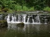
The area is in the centre of the Teirumnīki swamp, alongside a lake of the same name. There is a wooden footpath that crosses the swamp (800 metres). This is an excellent opportunity to study a high swamp, a swamp lake, and the surrounding environment.
|
|
 1 day
|
Ekskursijas laikā apmeklējiet dabas taku, kura izvijas augšup un lejup gar Pilsupes lejteces stāvajiem krastiem un atklāj skaistus skatus uz trīs balto smilšu atsegumiem, no kuriem vecākais ir 6000 gadu vecs. Pēc tam apmeklējiet Kubalu skolu - muzeju, kur redzēsiet, kādas izskatījās skolas 19 gs. Klasē Jūs sagaida senie skolas soli, tāfelītes, tinte un rakstāmspalva. Tālāk dodieties uz dabas parku, kurā izveidota Bišu taka. Iespēja kāpt kokā ar dzeiņa palīdzību, liet vaska sveces un iepazīt dažādos biškopības produktus. Ekskursijas noslēgumā dodieties uz mini zoo, kur ir iespēja apskatīt dažādus dzīvnieciņus - pundurkaziņas, punduraitiņas, mandarīnpīles. |
|
 |
The ancient Abava River Valley between Kandava and the place where the river flows into the Venta River is the most expressive river valley segment in Kurzeme in terms of landscape and terrain. The valley is 30 to 40 metres deep and as much as 300 metres wide. The territory is distinguished by great diversity of a biological nature (more than 800 kinds of plants), featuring many different biotopes and natural monuments such as streams, waterfalls, cliffs, huge rocks, and many cultural and historical monumentssmall towns such as Kandava and Sabile. In both cases, the town centres are national monuments of urban construction. Popular tourist destinations include Vīnakalns hill in Sabile, where wine-making grapes are grown, as well as the open-air art museum at Pedvāle. To protect cultural treasures, a cultural and historical territory, “Abava River Valley” has been established. Wild livestock live at Drubazas and Tēvkalni to “maintain” the landscape. There are nature trails for tourists, and the Abava is the most popular river for water tourists in Kurzeme. Information is available at the tourist information centres in Kandava and Sabile. such as castle hills, churches, ancient burial grounds, and
|
|
 |
This extensive territory to the South of Pāvilosta once was the site of warehouses and an oil base. The territory at this time is used for the extraction of raw materials. There is also a sawmill there. The sign at the entrance of the facility states that the area can be dangerous to visitors.
|
|
 |
Sēļu muiža, par kuru pirmās ziņas saistāmas ar 1561. gadu, ar seno ēku kompleksu un ainavu parku mūsdienās vēl joprojām darbojas kā pagasta administratīvais un kultūras centrs, kur tiek organizēti arī atpūtas un saviesīgi pasākumi. Neskatoties uz to, ka muiža vairākkārt ir tikusi pārbūvēta, tās senatnīgums ir vēl saglabājies. Sēļu pagasta Tautas nams piedāvā bezmaksas ekskursijas Sēļu muižas kompleksā un divas meistardarbnīcas: ādas apstrādes meistardarbnīca pie Benitas Audzes un kokapstrāde un galdniecība pie Uģa Vītiņa. |
|
 |
Pilsētas rajons dienvidos no Ventas grīvas, kura mūsdienās redzamā mazstāvu koka apbūve sāka veidoties 19. gs. vidū. Ostgala pirmsākumi meklējami 1836. g., kad Krievijas valdība, solot priekšrocības, aicināja apkārtnes zvejniekus apdzīvot smilšaino un kustīgo kāpu pārņemto piekrastes daļu. Ostgals ir atzīts par valsts nozīmes pilsētbūvniecības pieminekli. |
|
 |
Stupeļu Hill is 3 km to the South of the Vecumnieki-Ilūkste road. There are no signs, so the castle hill might be difficult to find. The Great Stupeļu Rock, which is discussed further on in this guidebook, is also hard to find when there is vegetation. Stupeļu Hill is approximately 30 m high, and it was one of the highest castle hills in the historical district of Selonia. Archaeologists say that it was first abandoned at the beginning of our era and then populated again during the late Iron Age. It is interesting that iron was extracted and processed near the castle hill. Archaeologists believe that this is the site of one of the earliest “cities” in the region. To the West of the hill is the Great Stupeļu Rock, which is 6.7 m long, 5.6 m wide and up to 2.7 m high. Above ground, it is 35 m3 large, and it may have been a cult location. During archaeological digs in the late 1970s, antiquities from the 10th to the 13th century were found here. |
|
 |
The Karaosta canal and its naval and submarine base date back to the tsarist era in advance of World War I. The former submarine base is now closed to visitors and is used for business purposes. The canal can be viewed from Pulvera Street and the restored Kalpaks bridge.
|
|
 |
SIA "3x9 zālītes" piedāvā ļoti plašu klāstu zāļu tējas un to maisījumus. Zālītes ievāktas Vecpiebalgas novadā, ekoloģiski tīrās pļavās un mežos. Zālītes vāktas atbilstoši dabas ritmam un mēness fāzēm. Kaltētas dabīgos apstākļos, saglabājot zālīšu vērtīgās vielas, smaržu un garšu. |
|
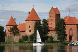 |
The Trakai Island Castle is the only East Europe's castle which is built on a little island. The process of building this castle started in 14th century. After its fall on 1410 during a war it lost its meaning as a military base and became a living place for ruler of Lithuania. Trakai Castle is one of the most popular objects in Lithuania for tourists. Inside the castle is a museum which tells about Trakai history.
|
|
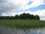 |
Of the many islands in Lake Rušons, ten are restricted natural areas so as to protect the broadleaf forests which are on the islands and the endangered plants found therein. An ancient cult location – the Rušons Sacrificial Rock – is found on Upursala island.
|
|
 |
Birch juice syrup with reverse osmosis is obtained. Technologically impressive view of 1.5 tons of water squeezed out of birch sap per hour. Here, reverse osmosis equipment can press 95% of pure water from birch sap. As a result, the sugar content of the remaining birch sap concentrate reaches 33% Brix. The concentrate is frozen and sold. |
|
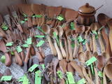 |
The spoon workshop offers useful objects such as wooden spoons, cutting boards, butter knives, pans, spatulas, etc. You can produce your own wooden spoon and look at finished spoons made of more than 17 different types of wood from Latvia. During the summer the owners offer “pancake tours” with tasty jams. You can purchase spoons and homemade wine. |
|
 |
The only school-based botanical garden in Lithuania was planted in 1989 at the Traupis school. More than 8,000 types of plants grow in the garden, and all of them have been collected by Sigutis Obelevičius. |
|


