
| Nr | Name | Beschreibung |
|---|---|---|
 |
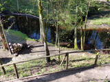
Gebaut im Jahre 1835 als Eigentum der Barone von Fircks nach Bestellung der Baronesse Tea von Fircks. Nach einem Umbau in 1883 erhielt das Gebäude ein herrschaftlicher Dekor im Stil der Renaissance und im manieristischen Stil und größerer Umfang des Baues. Am 15. Dezember 1905 wurde das Gebäude des Landguts von Revolutionären in Flammen gesetzt. Drei Jahre später fingen die Wiederherstellungsarbeiten unter der Leitung vom Architekt L. Reinīrs an. Im Gutsschloss sind eine Festhalle mit zwei Kaminen aus Marmor, in den Einzelräumen – ein am Anfang des 20. Jahrhunderts gelegtes Parkett und Außentürflügel mit Metallprägung zu besichtigen. 1938 wurde das Schloss umgebaut. In der Zeit des Zweiten Weltkriegs befand sich im Gebäude ein Kriegslazarett der deutschen Armee, aber nach dem Krieg – eine Schule für die Waldarbeiter. Seit 1962 befindet sich im Schloss die Schule von Rudbārži, die den Namen von Oskars Kalpaks trägt. An der Wand des Gebäudes befindet sich eine Gedenkplatte zu Ehren des Kalpaks-Bataillons. Am 22. Januar 1919 haben die Bolschewiken während des Lettischen Unabhängigkeitskriegs die Stadt Skrunda eingenommen. Sieben Tage später wurde das Kalpaks-Bataillon vom Landgut Rudbārži aus Richtung Skrunda angetreten. Nach einer dreistündigen Schlacht hat das Bataillon den Sieg behalten und eine strategische Position in der Nähe des Ufers des Flusses Venta eingenommen. Es war ein erster Sieg des Bataillons nach den mehrmaligen Rückzügen und es regte zu den weiteren Kämpfen an. |
|
 11 Tagen
|
A panoramic tour of Lithuania, Latvia, Estonia and Finland with highlights of nature experiences in the National parks and nature reserves. A variety of landscapes, nature attraction sites, birds and wild animals, forests and seashore. The tour also offers some cultural and historical insights. |
|
 |
Die Besitzer zuchten Shiitakepilze in einem Wald und bieten eine Exkursion mit Erzählung über die Zucht der Pilze und ihre gute Eigenschaften an. Erwerb der Pilze, Beratung. Die Besitzer bieten ökologische landwirtschaftliche Produkte und Honig an.
|
|
 |
Vairāki dažus metrus augsti smilšakmens atsegumi, kas izveidojušies Stiglavas (Stiglovas) strauta gravas nogāzēs. Kaut arī teritorija tiek popularizēta kā tūrisma objekts, tajā nav īpašu šim nolūkam paredzētu labiekārtojumu. Teritorijas apmeklētāji bojā smilšakmens atsegumus, kas ir aizsargājami biotopi!
|
|
 |
Nacionālā parka dienvidrietumdaļā jūrā iestiepjas Eldas pussala – skaists un ļoti omaļš ar kadiķu mežu (alvāriem) noaudzis zemes pleķītis ar interesantu jūras krastu, kur atsedzas silūra perioda nogulumieži. No pussalas gala, kurā slejas vecs Padomju armijas robežsargu tornis (apmeklējumam bīstams!), paveras visaptverošs skats uz Vilsandi salu (atpazīstama pēc bākas), Lonalaidas salu (Loonalaid) – otru lielāko Vilsandi arhipelāgā, Salavu (Salava) un citām mazākām saliņām. Dabas mīļotāji var uzmeklēt Eldas klinti (Elda pank) – ~ 2 m augstu un 0,4 km garu atsegumu, kura piekājē var atrast interesantas ūdens izskalotas fosilijas. |
|
 |
Dieses morastige Gebiet war Teil der Litorina - Meereslagune und ist ein Gebiet, wo es viele seltene und geschützte Vögel gibt, z.B. leben und nisten hier Spechte. Ein Teil des Territoriums kann von der Straße Tukums-Kolka aus überblickt werden.
|
|
 3 Tagen
|
Die Strecke führt durch die historischen Regionen Selonia und Latgallen. Sie beginnt und endet in Daugpilis (Dünaburg), der zweitgrößten Stadt Lettlands. In der Baumschule Selija beginnen wir mit einer Führung durch die Apfelplantage, die Fruchtlager und die Verarbeitungsräume. Probieren Sie ein Glas Apfelsaft und hören Sie die Geschichte der Apfelweinherstellung! Auf dem Weg dann ein Halt bei der Gedenkstätte für den berühmten lettischen Schriftsteller und Aktivisten Rainis in Birkinele. Der Anbau von Wein und die Zucht von Rebsorten war die große Leidenschaft von Pauls Sukatnieks, der Besuch der Gedenkstätte für ihn ist daher besonders zur Erntezeit geraten. In Kaldabruna kann man ein ganz besonderes Wiesenmuseum und eine Kunstgalerie in der Scheune besichtigen. Der im romantizistischen Stil angelegte dendrologische Naturpark das Gutes Asare hat seine Anfänge im 18. Jh. und bietet eine große Vielfalt an interessanten Bäumen und Sträuchern. Der Hof Riekstiņi in Nereta ist ein authentisch erhaltener Familienhof, mit der für die Region Selonia typischen Atmosphäre. Die evangelische Kirche von Nereta stammt aus dem Jahr 1584 und ist damit eins der ältesten erhaltenen Bauwerke aus Stein in der Region. Im Naturpark Sauka bietet sich vom Borīšukalns und von weiteren Hügel in der Nähe ein gute Sicht auf die Landschaft des Sees Sauka. Der Weinberg im Winzerhof „Rudzīši“ hat über 80 Rebsorten und im Hof „Bānīši“ kann man leckere Schwarze Johannisbeeren nach Bedarf pflücken. In Gundegas gibt es den reizvoll gestalteten Landschaftsgarten. Im Park in Varkava stehen 200-jährige Eichen. Im Regionalmuseum können Sie eine Ausstellung zum Haushalt und Hof eines wohlhabenden Bauern im 19. und 20. Jahrhundert besichtigen. Der Aussichtsturm Vasargeliški hat eine Höhe von 24 m und bietet großartige Sicht über die Daugava. Im Haus von Altgläubigen in Slutiški befindet sich ein Museum (als Filiale des Regionalmuseums Naujene), wo man sich mit Kultur und Traditionen der Altgläubigen (einer Richtung die von der orthodoxen Kirche abgespalten ist) bekannt machen kann. Im Hof Kurmīši werden heimische Arzneipflanzen angebaut, wie Dost, Johanniskraut, Kornblume, Katzenpfötchen usw. |
|
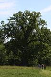 |
The tree is on the side of a hillock, and its visible roots are unusually huge.
|
|
 |
Established: 1959
60 coniferous and 350 deciduous trees
Brief description: Between the Tukums-Kolka road, the Lāčupīte stream and the sea, Igors Mednis has planted a series of foreign trees and shrubs. He has conducted experiments to see how different foreign plants adapt to different conditions. The best time to visit is in May and June, when the rhododendrons are in bloom.
|
|
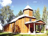 |
St. Anthony Roman Catholic Church of Pilcene (Piļcine) is the oldest wooden church in Latgale, built
in 1670. It is prominent because of its half columns, hexagonal tower, semicircular windows, and a dome
with a cross and antique interior.
|
|
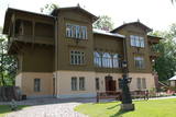 |
Am Ufer der Venta erhebt sich eine wahre Perle der Holzarchitektur - die mit romantischen Geschichten und Legenden umwobene und unlängst erneuerte „Villa Bangert“. Man erzählt sich, dass ein gewisser Kapitän Bangert dieses Gebäude seiner Braut in Paris gekauft habe. Seit 1940 befindet sich in diesem Haus das Heimatmuseum der Stadt Kuldiga. In dem Museum hat man nach der Rekonstruktion der Räume die einzigartigen Wandmalereien und verschiedene andere Details im Interieur wiederhergestellt und somit eine Exposition – die Wohnung der Familie Bangert - geschaffen, die uns ein Bild davon gibt, wie eine wohlhabende kuldigaer Familie zu Beginn der 20er Jahre gelebt hat. Ausserdem kann man hier auch die Kollektion des Spielkarten- Sammlers Jāņis Mētra sehen. |
|
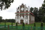 |
Meklējama Gosporos, starp Rīgas – Daugavpils šoseju (A 6) un Daugavu. Apjomā nelielais dievnams būvēts 1820. gadā romāņu stilā no laukakmeņiem senas kapsētas vietā. Tuvāk Daugavai ir izveidota aka, no kuras iztek Svētavots, kam piedēvē dziednieciskas īpašības. Pie baznīcas novietots dobumakmens. |
|
 |
Gegründet für den Schutz der Landschaften und der Seen der Aukštaitija-Anhöhe, Arten und Biotope. |
|
|
|
Pie Melekiem sākas dabas lieguma teritorija. Meleku
krastmala būtiski mainījās 2005. g. orkāna laikā.
|
|
 |
Pie Gārsenes pils atrodas bijušais muižas parks 4ha platībā un pie tā sākas arī Gārsenes dabas takas. Dabas takas vēsturiski tika veidotas vienlaicīgi ar pils kompleksa būvniecību un ieeja takās atrodama pie mākslīgi veidotā, ar bruģa pamatni izliktā barona peldēšanās dīķa. Takas sākumā saglabājusies ošu aleja, ko savulaik stādījis barona dārznieks, savukārt taku vidusposmā apmeklētājiem ir iespēja pasēdēt uz Barona krēsla - akmens ar cilvēku veidotu sēdvietu tajā. Kopumā Gārsenes mežā vijas dažāda garuma labiekārtotas pastaigu un izziņas takas - Kultūrvēsturiskā taka, Zaļā taka, Baronu pastaigu taka, Staburaga taka, ar ierīkotām atpūtas un ugunskuru vietām. Takās apskatāmi vairāk kā 40 unikāli dabas objekti, gan dižakmeņi, gan dižkoki, kā arī un pagasta ievērojamākie arhitektūras un kultūrvēstures pieminekļi. No 2016.gada maija Dabas takās ietilpst arī „Krēslas stundas taka”, kas īpaši patiks zinātkāriem mazajiem ceļotājiem. Taka stāsta par Rūķu dzīvi mežā un tās veidošanas pamatā ir stāsti no „Lielās Rūķu enciklopēdijas”. |
|
 2 Tagen
|
Это один из 6 маршрутов путешествий в серии «Насладитесь деревней!», который приглашает посетить «Дары села» – хозяйства и предприятия всевозможных видов и отраслей, которые открыты для посетителей и предлагают экскурсии, попробовать, осмотреть и приобрести свои изделия. Там можно увидеть домашних животных, современные сельские хозяйства, мастерские ремесленников, приобрести сельскохозяйственные продукты – хлеб, мед, домашнее вино и пиво, сыр, ягоды, фрукты, рыбу, мясо, овощи, чаи и другие, выращенные в деревне дары. По дороге можно отобедать в сельских корчмах. Примерное время прохождения маршрута: два - три дней, в зависимости от количества выбранных достопримечательностей и времени, отведенного для их осмотра. |
|
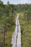 |
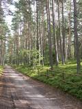
Ein 3,5 km langer Pfad quert den Viru Moos in Richtung Süd–Nord. Von einem Holzaussichtsturm eröffnet sich einen Blick auf eine typische Hochmoorlandschaft mit einigen Seen, Aushöhlungen und morastigen Stellen. |
|
 |
This is one of the most beautiful gardens in Latvia, and the owners of the garden will offer you a tour, along with valuable advice. Visitors can purchase trees, bushes, winter plants, perennials, medicinal plants, as well as edible flowers. Florist services are also available. |
|
 |
Die etwa 50 Rinder weiden ganzjährig im Freien, weswegen man sie auch jederzeit besichtigen kann. Sofern vorhanden, können die Besucher das Fleisch der Highland-Rinder verkosten. Zudem besteht die Möglichkeit, die traditionellen kleinrassigen litauischen Pferde Zemaitukai zu besichtigen und zu reiten. Das Programm der Führung wird eher für Erwachsene empfohlen. |
|
|
|
Die auf dem Berg Dievukalns (Gottesberg) gefundenen Zeugnisse erzählen davon, dass sich an diesem Ort vor 3000 Jahren baltische Stämme, aber vom 7. – 9. Jh. an dem Fluss Daugava – livische Stämme niedergelassen hatten. An dem felsigen Ufer von Daugava (zum ersten Mal im Jahr 1229 erwähnt) hat der Bischof von Riga eine Burg aus Feldsteinen gebaut, deren Ruinen man auch heute besichtigen kann. Lielvārde hat solche lettischen Kulturmitarbeiter wie Andrejs Pumpurs (1841-1902) und Auseklis (1850-1879) inspiriert. Während des Ersten Weltkriegs (der Fluss Daugava war fast drei Jahre lang die Frontlinie) wurde Lielvārde völlig zerstört. Nach dem Zweiten Weltkrieg wurden hier genauso wie im ganzen Lettland Kolchosen eingerichtet. In dieser Zeit wurde Lielvārde noch mit einem Symbol – mit dem Bier Lāčplēsis bekannt. Heute haben Lielvārde die Reisenden beliebt, die ihre Reiseroute entlang dem rechten Ufer des Flusses Daugava gewählt haben. |
|


