
| Nr | Nosaukums | Apraksts |
|---|---|---|
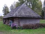 |
Ciemojoties pie Trīszvaigžņu ordeņa kavalieres, suitu kultūras mantojuma sargātājas, dziesminieces, teicējas Lidijas Jansones, jūs uzzināsiet par suitu vēsturi, tradīcijām un īpašo burdona dziedāšanu, kā arī uzzināsiet, kā senāk mājas apstākļos tapis alus, ko mūsu senči brūvējuši godos un svētkos. |
|
 |
Lietuvas augļkopības un dārzkopības institūts 1992. gadā ieguva valsts zinātniskā institūta statusu. Tas pilda ne vien zinātniecisku, bet arī eksperimentālās ražošanas darbību. Šajā institūtā audzē lietuviešu augļus un dārzeņus, no tiem ražo augstākās kvalitātes, veselīgus un dabiskus produktus. |
|
 |
Viena no iespaidīgākajām Baltijas reljefa formām. Pie Siguldas tā sasniedz maksimālo dziļumu – 85 m (ap 1 km plata). Tās pievilcība ir skaistie devona perioda smilšakmens atsegumi. |
|
 |
Apmeklētāji tiek pieņemti visa gada garumā, bet vislabākais saimniecības apmeklēšanas laiks ir pavasaris un vasara. Saimniecībā norisinās lekcija par augiem 45 minūšu garumā, pēc kuras seko 30 minūšu augu kolekcijas apskate ārā. |
|
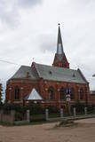 |
Atrodas t.s. Baznīcu kalnā – 18. novembra ielā 66. Apjoma ziņā – lielākais Daugavpils luterāņu dievnams, kuru cēla laikā no 1891. - 1893. g. neogotiskā stilā no sarkanajiem ķieģeļiem (arhitekts Vilhelms Neimanis). 1941. g. baznīcā izcēlās ugunsgrēks un gāja bojā lielākā daļa no tās sākotnējās iekārtas. Turpmāko divu gadu laikā baznīcu daļēji atjaunoja, taču vēlāk tajā izveidoja noliktavu u.c. baznīcai „nepiederīgas” iestādes. 1985. g. ēka vēlreiz cieta ugunsgrēkā. Pagājušā gadsimta deviņdesmito gadu sākumā uzsāka baznīcas atjaunošanas darbus, uzstādīja solus un altāri, kas ir Ogres Amatniecības vidusskolas audzēkņu darinājums. |
|
 |
Teritorija, kas ietver piekrastes posmu starp Ventspils – Liepājas šoseju un Baltijas jūru abpus Užavas upes lejtecei. Dibināta dažādu piekrastes biotopu, piemēram, pelēko kāpu un augu sugu aizsardzībai. Dienvidos no Užavas ietekas atrodas viena no romantiskākajām piekrastes bākām – Užavas bāka, kas celta stāvas kāpas galā. |
|
 |
Kaut arī Cēsis ģeogrāfiski atrodas Gaujas nacionālā parka vidienē, pilsētai nav nacionālā parka statusa. Taču Cēsīs ir daudzi interesanti apskates objekti, kurus ir vērts redzēt un izzināt tuvāk. Noteikti ir jāiepazīst Cēsu vecpilsēta! Cēsu pirmsākumi ir meklējami 18 m augstajā Riekstu kalnā un tā tuvākajā apkārtnē, jo 11. – 13. gs. te atradās vendu no koka celtā pils. Riekstu kalns meklējams Pils parka vidusdaļā, un no tā paveras labs skats uz Pils parku, dīķi un Cēsu pilsdrupām, līdz kurām var nokļūt pa garu kāpņu kaskādi. 13. gs. sākumā celtā Cēsu pils (aprakstu sk. tālāk pie Nr. 44.) bija ordeņa mestru rezidence un viens no stiprākajiem ordeņa cietokšņiem tagadējās Baltijas teritorijā. Tai blakus atrodas Cēsu Jaunā pils, kas celta 1777. g. vārtu nocietinājumu vietā. Ēkā ir iekārtots Cēsu Vēstures un mākslas muzejs, bet piebūvē mājvietu atradis Pils kompleksa apmeklētāju centrs un Cēsu tūrisma informācijas centrs. Ja uzkāpsim pils tornī, no tā pavērsies labs skats uz pilsdrupām, Sv. Jāņa luterāņu baznīcu un pilsētas ziemeļdaļu. Iepretim Cēsu Jaunai pilij atrodas vairākas ēkas – Cēsu pilsmuižas stallis un ratnīca (abas ēkas celtas 19. gs. pirmajā pusē), kur mūsdienās meklējams Cēsu Izstāžu nams. Pils kompleksa teritorijā no ārpuses ir apskatāma arī klēts, kučieru namiņš un vecā alus darītava. Ielas pretējā pusē atrodas romantiskais Maija parks, kurš iekārots 19. gs. trīsdesmitajos gados. To iecienījuši vecāki ar bērniem, jo te izveidots rotaļlaukums. Dosimies tālāk pilsētas ielās (Lielās Katrīnas, Mazās Katrīnas, Mazā Kalēju, Kalēju, Lielā Līvu iela un Līvu laukums) un apskatīsim 18. – 19. gs. mijā tapušo koka apbūvi. Torņa ielā, kas vijas gar Viduslaiku pils aizsargmūri, pie baznīcas apskatāma M. Jansona skulptūra „Gadsimtiem ejot". Ticējums vēsta, ka paberzējot Laika veča lukturi, ir iespējams redzēt nākotni. Viena no iespaidīgākajām Cēsu celtnēm ir Sv. Jāņa luterāņu baznīca, kas būvēta 13. gs. beigās kā Livonijas ordeņa Doms. Tā ir romānikas stila trīsjomu bazilika ar gotikas elementiem ar 1853. g. celto 65 m augsto torni. Ēka vairākkārt ir pārbūvēta arī 20. gs. Dievnamā apskatāmas Livonijas ordeņa mestru un Livonijas bīskapu kapa plāksnes. Kancele taisīta 1748. g., ozolkoka altāris - 1858. g., bet altārgleznu "Krustā sistais" - 1862. g. Baznīcas altārdaļas logus rotā mākslinieciski vērtīgas vitrāžas. Ērģeles 1907. g. darinājusi E. F. Valkera firma, un tās ir vienas no labākajām Latvijas koncertērģelēm. Dievnama dienvidrietumu stūra atbalstā iemūrēts saules pulkstenis ar gada skaitli "1744". Ir vērts uzkāpt baznīcas skatu tornī. Baznīcas pakājē atrodas Rožu laukums jeb bijušais Tirgus laukums (13. gs. vidus – 1927. g, atjaunots 2008. g), kas mūsdienās ir pilsētas centrālais laukums. Viduslaikos šeit ir atradies arī soda stabs un pilsētas aka. Rīgas iela no pilsētas pirmsākumiem veidojusies par galveno vecpilsētas ielu. Šeit aplūkojams vairākums Cēsu arhitektoniski izcilāko 18. -19. gs. celtņu – bijušais Cēsu rātsnams, Fābera nams, Princešu nams. Vienā ielas galā atrodas Līvu laukums, kur 13. gs. atradās baznīca, kapsēta un Rīgas vārti pilsētas mūrī. Šodien laukumu rotā izgaismota strūklaka, kuras vietā 13. gs. atradusies aka - Lejas Šķimbēgs. Otrā ielas galā atrodas 14. - 15. gs. pilsētas mūra Raunas vārtu pamatu un virszemes fragmentu rekonstruētā daļa. Tā rada labu priekšstatu par viduslaiku mūri, vārtu lielumu un pamatīgumu. |
|
 |
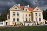
Par pils prototipu kalpojusi Anglijas Vindoras pils. Ēkas celtniecība pabeigta 1883. gadā. Muižas pēdējais īpašnieks bija Fridriks fon Bergs (1845. - 1938.) - pazīstams graudaugu selekcionārs. Parks. |
|
 |
Senais kuršu pilskalns atrodas pašā Alsungas centrā. Nosaukumu tas ieguva 1659. gadā, kad Kurzemes ģenerālis Bergs šeit izvietoja lielgabalus, lai apšaudītu Alsungas pilī nocietinājušos zviedru spēkus. Pilskalna augstums ir 8 – 10 metri (plakums 22 x 54 m) un no tā paveras lielisks skats gan uz Alsungas Sv. Miķeļa Romas katoļu baznīcu, gan uz blakus esošo Alsungas dzirnavu ezeru. Apkārt pilskalnam stiepjas izteikta terase, uz kuras bijušas koka aizsargbūves. Pils ielas otrā pusē (uz rietumiem no pilskalna) atrodas Kalniņu kapulauks ar 11. – 13. gs. kuršu ugunskapiem, ko arheologi izpētīja pagājušā gadsimta vidū. Dižgabalkalnā suiti svin Lieldienas un Zāļu dienu. |
|
 |
Šeit var iepazīties ar lauku sētas ikdienas darbiem un rosību, apskatīt Igaunijas vietējās aitas (tumšgalves) un uzzināt vairāk par to kopšanu. Senkultūras takas apmeklētāji varēs uzzināt par igauņu senču dzīvi un lauku sētas vēsturi (viensētas teritorijā atrodas akmens senkapi un svētbirze). Pēc vēlēšanās var iepazīties ar rokdarbu darināšanu un apstrādāt aitas vilnu. |
|
 5 dienas
|
Senie tirdzniecības ceļi izplatīja ne tikai preces, bet arī zināšanas un kultūru, visu tobrīd jauno un nezināmo. |
|
 |
Neapšaubāmi, Palmses muiža ir viens no skaistākajiem un greznākajiem Igaunijas muižu kompleksiem. Muiža rakstiskajos avotos ir pieminēta jau 1510. g. kā Tallinas cisterciešu sieviešu klostera īpašums. Vēlākajos gadsimtos tā ilgstoši piederēja grāfu Pālenu dzimtai. Muižas pili uzcēla 1697. g., taču tagadējo izskatu tā ieguva 18. gs. pēc rekonstrukcijas. Muižas ēkas vēlreizēju atjaunošanu piedzīvoja pagājušā gadsimta 70. – 80. gados. Palmses muižu ieskauj liels un ainavisks parks ar dīķiem un paviljoniem, kā arī daudzas saimniecības ēkas, kas mūsdienās tiek izmantotas. Muižas pilī var iepazīt greznos interjerus, paviesoties tās pagrabos un iegādāties Igaunijā ražotu vīnu. Muižas stallī – ratnīcā atrodas Lahemā nacionālā parka apmeklētāju centrs, kur apskatāma parkam veltīta ekspozīcija. |
|
 |
Zasas muižas parks atrodas Zasas dzirnavu dīķa (Zasas ziemeļdaļā) uzpludinātās Zasas upītes krastos. Parka izveidi uzsāka 18. gs. un to veidoja kā ainavu parku romantiskā stilā. Vienlaicīgi ar parku, uzsāka arī Zasas muižas pils celtniecību. Tās īpašnieks bija Heinrihs fon Zass, kura vārdā nosaukta Rīgas daļa Zasulauks. 19. gs., kad mainās muižas īpašnieks, Zasas muižu uzskata par vienu no bagātākajām un skaistākajām apkaimes muižām. Ir vērts izstaigāt plašo parku ar daudzajiem tiltiņiem, Vilkaču koku, Velna akmeni un svētavotu. Muižas parka apskate gida pavadībā: +371 26337227. |
|
 |
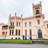
Zvārtavas pils aicina ceļotājus un dabas draugus, kultūras un mākslas cienītājus iepazīties ar Zvārtavas pili un citiem muižas kultūrvēsturiskiem objektiem, izbaudīt parku un ezeru, izzināt novada vēsturi un apskatīt mākslas darbus, kuri radīti šeit plenēros un rezidencēs, gan LMS muzeja kolekcijas ekspozīcijas un aktuālās izstādes. Skaistā Zvārtavas pils celta 1881.gadā un ir viena no spilgtākajiem neogotikas stila arhitektūras pieminekļiem Latvijā, kas ir valsts nozīmes kultūras piemineklis. Pašlaik pils pieder Latvijas Mākslinieku savienībai, un tieši šis fakts ir pamats pils unikalitātei. Pilī ir saglabājušies neogotikas interjeri, koka kolonas vestibilā, oriģinālās parketa grīdas, mēbeles un stikla kupols ar vitrāžām, caur kurām gaisma dažādos toņos, veido zīmējumus uz sienām un grīdas. |
|
 |
Alūksnes Jaunā pils celta 19. gs. vidū, viens no ievērojamākajiem vēlās Tjūdoru neogotikas arhitektūras pieminekļiem Latvijā. Pils iekštelpas sevī slēpj dažādu arhitektūras stilu mākslinieciskos sienu un griestu gleznojumus, no kuriem daļa ir atsegta. Pils telpās ir iekārtots un Alūksnes muzejs ar ekspozīcijām par pilsētas kultūrvēsturiskā mantojuma īpatnībām un tā daudzveidību un Dabas muzejs “Vides labirints”. Pie pilis piegulošais Muižas parks ir veidots kā dabisks ainavu parks, kas kalpo kā lieliska izvēle mierpilnai pastaigai. Tas ieskauj tādus mazās arhitektūras meistardarbus, kā Aleksandra paviljons, sengrieķu Vēju dieva Eola templis, Putnu paviljons, granīta obelisks, Pomonas templis, baronu dzimtas mauzolejs un no viena granīta gabala veidots strūklakas baseins un granīta soli. |
|
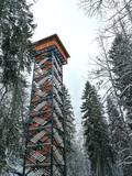 |
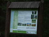
Dabas liegumā "Lielie Kangari" atrodas 33 metrus augsts skatu tornis, kura virsotnē atrodas platforma, no kuras paveras skats uz Kangaru ezeru un Lielkangaru purvu. Dabas liegumā izbūvēta arī nepilnu divu kilometru gara pastaigu taka ar tiltiņiem un skatu platformu pie ezera. Takas sākumā izvietotais veselības maršruts ikvienu apmeklētāju aicina kārtīgi izvingroties un izkustēties. Apmeklētāju informēšanai un izglītošanai visas takas garumā izvietoti arī informatīvie stendi ar fotogrāfijām, kas apvieno varenu stāstu un teiku kopumu par notikumiem, vietām, tēliem un parādībām dažādās apkārtnes vietās. |
|
 |
Tas atrodas pie „Burtnieku” mājām Īlē, kur viņš dzīvojis no 1837. – 1845. gadam. Tēvs Juris Barons apglabāts Īles kapsētā. Savu vārdu nemirstīgu Krišjānis Barons darījis, vācot, sistematizējot un sastādot Latvju Dainu krājumu. Tautasdziesmas jeb dainas ir mazi, ritmiski dzejolīši, parasti četrrindes. Pie Latvju dainu vākšanas Barons pavadījis sava mūža lielāko daļu – apmēram 25 gadus gandrīz dienu pie dienas. |
|
 |
Ārstniecības un garšaugu dārzs, apskates un degustācijas programmas. Maizes, piparkūku cepšanas programmas. Piena ceļa programma. Tradicionālā siera gatavošanas programma. Papildus praktiskajām lietām, iespējams iepazīties arī ar muzejā esošajiem darba rīkiem un sadzīves priekšmetiem, kas saistīti ar konkrēto tēmu. Plašas tradicionālās kultūras zināšanas. |
|
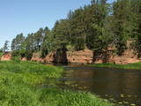 |
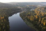
Mazskarts Salacas upes ielejas posms ar lielu smilšakmens iežu atsegumu, netraucētu alu u.c. biotopu, sugu un ainavu daudzveidību. Salaca ir viena no nozīmīgākajām Baltijas jūras lašupēm un otra populārākā Vidzemes ūdenstūristu upe. Kā galvenie apmeklētāju piesaistes objekti jāmin ģeoloģiskie pieminekļi - Sarkanās klintis, Skaņais kalns, Neļķu klints, Velna ala un kultūras pieminekļi - Lībiešu pilskalns, Vecsalacas muiža, Lībiešu muzejs, Valtenberģu muiža, unikālie Salacas nēģu tači u.c. Parkā atrodas viens no Ziemeļvidzemes populārākajiem tūrisma objektiem – Skaņākalna parks, kurā izveidots blīvs taku tīkls. Salaca ir arī populārs makšķernieku galamērķis. Ietilpst Ziemeļvidzemes biosfēras rezervāta teritorijā. |
|
 |
No ģeogrāfiskā un kultūrvēsturiskā viedokļa interesanta teritorija Latgales augstienes Rāznavas paugurainē, kuras nozīmīgākie resursi ir dažāda veida biotopi, ainavas, reljefs un Šķaunes ezers. Istras pauguraines dabas parkā nav ar tūrismu saistīti labiekārtojumi, bet šo teritoriju var apskatīt arī „no malas”, braucot pa grantēto ceļu no Soboļinas uz Osinovku, kas iet līdztekus parka ziemeļu robežai (skats uz Šķaunes ezeru).
|
|


