
| No | Name | Description |
|---|---|---|
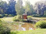 |
One of the oldest botanical parks in Lithuania, this one was opened by Izidoras Navidanskas in 1928, when he was only 16. In 1965, the park because the Žemaitija botanical park, and Navidanskas and his son, Rapolas, who is the current owner, did a lot to expand it. |
|
 |
The Krāslava Catholic Church was built between 1755 and 1767 after a design by the Italian architect A. Paracco, and it is considered to be Latgale’s most outstanding Baroque monument. The interior can be toured, and you can also visit the restored cemetery where members of the Plater family of noblemen are buried. |
|
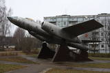 |
A rare monument survives in Skulte – a Soviet-era jet bomber, the IL-28, which supposedly was equipped to carry winged missiles. The airplane is on three cement pedestals.
|
|
 |
The Forest House (Meža māja) was built
in 1933, and this is one of the most
outstanding buildings in Latvia from the style
of National Romanticism. It used to house an
enormously popular restaurant, “Merry
Mosquito" (Jautrais ods). The restaurant was
popular among the spa’s guests, but also
among prominent people of the day. A
children’s sanatorium was installed here after
World War II for kids from all over the Soviet
Union. When the Ķemeri National Park was
established in 1997, the building became its
headquarters and today it is a modern visitors’
centre.
|
|
 |
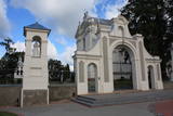
Atrodas vēsturiskā rātslaukuma dienvidu malā. Jaunā rātsnama celtniecība (itāļu renesanses stilā, arhitekts O. Dīce) tika pabeigta 1860. gadā. Iespaidīgo celtni, kas nulle kā atjaunota, ir vērts apskatīt gan no āra, gan iekšpuses. Ir restaurēts rātsnama pulkstenis, ārējā fasāde, iekšējie interjeri un Lielā zāle. |
|
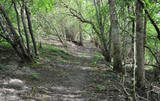 |
4 km garā un marķētā taka iepazīstina ar dziļo Imulas ieleju – Abavas kreisā krasta pieteku. Īpaši iespaidīga ieleja izskatās bezlapu periodā, kad ir apjaušami tās izmēri un formas. Vēstures cienītāji var upes gultnē uzmeklēt Langsēdes Velna pēdas akmeni. Atrodas dabas parkā „Abavas senleja”. |
|
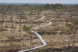 |
Taka iesākumā ved pa mežu ieskautu bijušo šaursliežu dzelzceļa līniju, pa kuru pagājušā gadsimta vidū izveda kokmateriālus. Tās tālākā daļa izmet nelielu loku pa Suistna purvu (Suistna raba), kur uzcelts skatu tornis ar izcilu sūnu purva ainavu ar nelieliem ezeriņiem. Takas garums vienā virzienā ir 4,5 km. |
|
 |
Lauku mājā "Celmiņi" iespējams dzirdēt farmaceites Valentīnas Dāboliņas stāstus par veselību stiprinošiem ārstniecības augiem. Tiek piedāvāta augu atpazīšana un tēju vākšana, kā arī tēju degustācija un iegāde. |
|
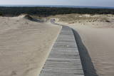 |
This is the only place in the Baltic States where there is such a vast territory of open-air sand dunes which still change the local terrain very actively because of the wind. The only Sea Museum and Dolphinarium in the Baltic States can be found here.
|
|
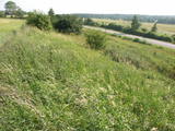 |
This territory protects the shore of the onetime Baltic lake of ice, which most significant part stretches for 10 kilometres on the eastern side of the Grobiņa-Ventspils highway from Kapsēde till Vērgale bus stop. From the top of this ancient shoreline there is a lovely view of the Piejūra lowlands, but no specific viewing areas or information stands have been installed. There are protected species and habitats in the territory. |
|
 |
The saloon is on the edge of the Murjāņi-Valka road (A3) and is easily recognised because of the building and various fairy tale characters in the yard. Latvian cuisine: Cold soups (beet, bean, sauerkraut, sorrel), roast leg of pork, blood sausage, pork ribs, berry dessert with toasted oats, stacked rye bread. Special foods: “Fiery Soup of the Ragana Kitchen”. |
|
 |
SIA Mikaitas is a family company that was established in 2005 and breeds purebred sheep. It provides seed for other herds to breed fast-growing lambs with excellent taste. The farm breeds the Oxforddown breed of sheep and sells lambs of various ages, breeding sheep and rams, yarn, wool products, processed sheepskin, sheep, mutton and various meat products. |
|
 |
The organic farm Zemturi is a 30 min drive from Kuldiga. The farm is mainly engaged in breeding rabbits and is designed as a place for children to see, learn about rabbits, birds and other pets. The hosts have created two thematic trails, one for pets and poultry and the other for trees and flowers. Sauna lovers have access to the sauna, also fishing opportunities can be used. Overnight stays with family or a small group of friends are also offered. Excursions for big and small. |
|
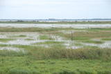 |
The Lake Lubāns, wetland of Lubāns. Lubāns (80.7 km2) is the largest lake in Latvia and the most popular
lake and wetland in Europe. The lake and the wetland has biodiversity; a unique place not only in Latvia,
but also internationally. Nature Reserve is included in the European Union network of protected areas and
NATURA 2000 under the Ramsar Convention criteria as the wetland of international importance. Lubāns wetland,
called marshy meadows, includes bogs, wet meadows and wet forests. In autumn and spring the lake
attracts thousands of migratory waterfowl which is easily to wach from the bird observation towers or the terrace
of water tourism development center.
|
|
 |
The largest city near the Liv Coastline, where visitors will find the Ventspils branch of the Liv Association and the Liv ensemble "Rāndalist." In nearby Tārgale are the Liv ensembles "Kāndla" and "Piški kāndla." |
|
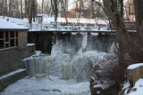 |
Atrodas pie Kuldīgas pils dzirnavām, kur straujā Alekšupīte pirms ietekas Ventā izgrauzusi dziļu „kanjonu” dolomītā. Šo dēvē par vienu no augstākajiem Latvijas ūdenskritumiem (4,15 m). 17. gs. ūdenskritumu ievērojami pārveidoja – paaugstināja un nostiprināja, lai Alekšupītes straumi izmantotu dzirnavu darbināšanai. Upītes kreisais krasts ir labiekārtots. |
|
 |
Jelgavas pils dienvidaustrumu spārna cokolstāvā ir iepazīstamas Kurzemes un Zemgales valdnieku - Ketleru un Bīronu dzimtas kapenes (laika posms no 1569. – 1791. g.), kur apskatāmi 18 restaurētie sarkofāgi. Šī ir Baltijas mērogā nozīmīga vieta, kas noteikti jāapmeklē ikvienam vēstures interesentam. |
|
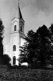 |
The first building of the church was built in 1641. The fourth building of the church was only built in 1856 – during the times of Pastor Johann Wilhelm Knierim. Its altar painting – The Crucified Christ (Golgotha) was painted in 1856 by Jozeps Millers, who was influenced by the altar piece in Munich Louis Church created by his teacher Peter Cornelius. An epitaph of Baroness Auguste Amalija von Pistohlkros, the sister of the owner of Bīriņi Manor and the patroness of the church, was immured in the memorial wall. Construction of the tower was completed on 11 June 1856, as evidenced by a memorial plaque on the wall of the church with an inscription “Erbaut von August Pistolkors 1856”. The church was consecrated in 1864. And a year later an organ by Martin Company with 8 registers, which was extended to 14 registers in 1903, was installed in the church. Unfortunately, the organ was destroyed in WW2. Saulkrasti (Pēterupe) Evangelical Lutheran Church survived both World War 2 and the Soviet period. The Soviet era was one of the most difficult times for the church, because many churches in the area were destroyed, pastors were discharged and the congregation fell apart. The Pēterupe congregation remained. As an architectural monument the church was lucky enough to undergo roof repairs of the tower even during Soviet times. Funds were granted by the Chairlady of the Executive Committee Ņina Manzūrova. |
|
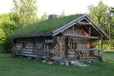 |
The ancient sauna house is a great place for rest and relaxation in Hiiumaa. The house is built of thick logs and has a sod roof. The house has a sauna. |
|
 |
The saloon is in the centre of Jelgava alongside the bridge over the Driksa River, where there is a new shoreline promenade. Wood has been used for interior design, and the saloon regularly organises musical evenings. Latvian cuisine: Cold soup, roast filet of plaice or cod farmer’s breakfast, potato pancakes, crepes. |
|


