
| Nr | Nosaukums | Apraksts |
|---|---|---|
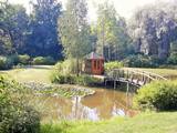 |
Tas ir viens no pirmajiem Lietuvas botāniskajiem parkiem. 1928.gadā I.Navidanskas, kuram tolaik bija vien 16 gadu, uzsāka parka veidošanu. 1965.gadā parku nodēvēja par Žemaitijas botānisko parku. Izidors kopā ar dēlu Rapolu, kurš šobrīd ir parka īpašnieks, turpināja paplašināt parku. |
|
 |
Храм (ярчайший памятник барокко в Латгалии) строился в период с 1755 по 1767 год по проекту итальянского архитектора Антонио Парако.В мире верующих это - очень важное место, потому что в 1775 году из Рима привезли реликвии патрона Краславы Святого Доната, которые в 1818 году поместили в специально построенной для этой цели часовне. С 1790 года вплоть до сегодняшних дней в первое воскресенье после дня Святого Петра празднуется день Святого Доната. В храме 13 алтарей. Автор фрески центрального алтаря «Святой Людвиг отправляется в Крестовый поход» - итальянский художник Ф. Кастальди. Позднее центральный алтарь дополнили алтарной иконой польского художника Я.Матейко такого же названия. В погребах церкви (восстановлены) можно осмотреть гробницу графов Платеров, созданную в 1775 году. Церковь осматривается изнутри. |
|
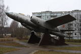 |
В поселке Скулте сохранился редкий памятник – реактивный бомбардировщик (IL-28) советских времен, который как будто мог переносить и крылатые ракеты. Самолет размещен на трех бетонных постаментах.
|
|
 |
Межа мая – здание, построенное в 1933 г.,
является одним из самых ярких строений
национального романтизма в Латвии.
Первоначально здание служило в качестве
широко известного в округе ресторана "Яутрайс
одс" ("Веселый комар"). После Второй мировой
войны в здании разместился детский санаторий
"Межа мая" (Лесной дом). С 1997 г. с
созданием Кемерского национального парка,
"Межа мая" стало зданием администрации и
одновременно современным центром для
посетителей, а также местом проведения
различных экологопросветительских
мероприятий.
|
|
 |
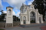
Atrodas vēsturiskā rātslaukuma dienvidu malā. Jaunā rātsnama celtniecība (itāļu renesanses stilā, arhitekts O. Dīce) tika pabeigta 1860. gadā. Iespaidīgo celtni, kas nulle kā atjaunota, ir vērts apskatīt gan no āra, gan iekšpuses. Ir restaurēts rātsnama pulkstenis, ārējā fasāde, iekšējie interjeri un Lielā zāle. |
|
 |
4 km garā un marķētā taka iepazīstina ar dziļo Imulas ieleju – Abavas kreisā krasta pieteku. Īpaši iespaidīga ieleja izskatās bezlapu periodā, kad ir apjaušami tās izmēri un formas. Vēstures cienītāji var upes gultnē uzmeklēt Langsēdes Velna pēdas akmeni. Atrodas dabas parkā „Abavas senleja”. |
|
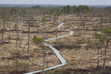 |
Taka iesākumā ved pa mežu ieskautu bijušo šaursliežu dzelzceļa līniju, pa kuru pagājušā gadsimta vidū izveda kokmateriālus. Tās tālākā daļa izmet nelielu loku pa Suistna purvu (Suistna raba), kur uzcelts skatu tornis ar izcilu sūnu purva ainavu ar nelieliem ezeriņiem. Takas garums vienā virzienā ir 4,5 km. |
|
 |
Lauku mājā "Celmiņi" iespējams dzirdēt farmaceites Valentīnas Dāboliņas stāstus par veselību stiprinošiem ārstniecības augiem. Tiek piedāvāta augu atpazīšana un tēju vākšana, kā arī tēju degustācija un iegāde. |
|
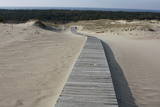 |
This is the only place in the Baltic States where there is such a vast territory of open-air sand dunes which still change the local terrain very actively because of the wind. The only Sea Museum and Dolphinarium in the Baltic States can be found here.
|
|
 |
This territory protects the shore of the onetime Baltic lake of ice, which most significant part stretches for 10 kilometres on the eastern side of the Grobiņa-Ventspils highway from Kapsēde till Vērgale bus stop. From the top of this ancient shoreline there is a lovely view of the Piejūra lowlands, but no specific viewing areas or information stands have been installed. There are protected species and habitats in the territory. |
|
 |
Находится на обочине шоссе Мурьяни – Валка (A3) и легко узнаваема по строению и всевозможным сказочным образам, которые установлены во дворе корчмы. Латышская кухня: Супы (холодный свекольный, фасолевый, из кислой капусты, щавелевый), жареная свиная голень, кровяная колбаса, свиные ребрышки, ягодный кисель с хрустящими овсяными хлопьями, слойка из черного хлеба. Особое блюдо: «Огненный суп кухни ведьмы». |
|
 |
Предприятие по разведению породистых овец ООО «Мукайтас» – семейное предприятие, основанное в 2005 году. Миссия предприятия – предлагать мясопроизводственным стадам племенной материал, который дает быстрорастущих ягнят с отличными мясными качествами. В хозяйстве разводят овец породы Oxforddown. В хозяйстве можно приобрести породистых ярочек разного возраста, племенных овец и баранов, пряжу, изделия из шерсти, обработанные шкуры овец, овец для стравливания травы, баранину и разные мясные изделия. |
|
 |
The organic farm Zemturi is a 30 min drive from Kuldiga. The farm is mainly engaged in breeding rabbits and is designed as a place for children to see, learn about rabbits, birds and other pets. The hosts have created two thematic trails, one for pets and poultry and the other for trees and flowers. Sauna lovers have access to the sauna, also fishing opportunities can be used. Overnight stays with family or a small group of friends are also offered. Excursions for big and small. |
|
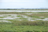 |
Озеро Лубанас, Лубанские топи. Озеро Лубанас по площади самое большое озеро (80,7 кв.км) в
Латвии, самое большое запруженное озеро в Европе, а территория вокруг него по биологическому
разнообразию – уникальное место не только в Латвии, но и в международном масштабе. Природный
заповедник включен в сеть (NATURA 2000) защищаемых территорий Европейского союза и
соответствует критериям Рамсарской конвенции, т.е. топи международного значения. Лубанские топи,
которые местное население уже издавна называет плавнями, – низкие и высокие болота, мокрые
луга, влажные леса. Осенью и весной на водохранилищах останавливаются тысячи мигрирующих
водоплавающих птиц, за которыми удобно следить из башен наблюдения за птицами либо с террасы
центра развития водного туризма.
|
|
 |
Ближайший к берегу ливов город, в котором действует Вентспилсское отделение Сообщества ливов, ансамбль ливов «Рандалист» («Rāndalist»), а в соседнем Таргале – ансамбли ливов «Кандла» («Kāndla») и «Пишки кандла» («Piški kāndla»). |
|
 |
Atrodas pie Kuldīgas pils dzirnavām, kur straujā Alekšupīte pirms ietekas Ventā izgrauzusi dziļu „kanjonu” dolomītā. Šo dēvē par vienu no augstākajiem Latvijas ūdenskritumiem (4,15 m). 17. gs. ūdenskritumu ievērojami pārveidoja – paaugstināja un nostiprināja, lai Alekšupītes straumi izmantotu dzirnavu darbināšanai. Upītes kreisais krasts ir labiekārtots. |
|
 |
Jelgavas pils dienvidaustrumu spārna cokolstāvā ir iepazīstamas Kurzemes un Zemgales valdnieku - Ketleru un Bīronu dzimtas kapenes (laika posms no 1569. – 1791. g.), kur apskatāmi 18 restaurētie sarkofāgi. Šī ir Baltijas mērogā nozīmīga vieta, kas noteikti jāapmeklē ikvienam vēstures interesentam. |
|
 |
The first building of the church was built in 1641. The fourth building of the church was only built in 1856 – during the times of Pastor Johann Wilhelm Knierim. Its altar painting – The Crucified Christ (Golgotha) was painted in 1856 by Jozeps Millers, who was influenced by the altar piece in Munich Louis Church created by his teacher Peter Cornelius. An epitaph of Baroness Auguste Amalija von Pistohlkros, the sister of the owner of Bīriņi Manor and the patroness of the church, was immured in the memorial wall. Construction of the tower was completed on 11 June 1856, as evidenced by a memorial plaque on the wall of the church with an inscription “Erbaut von August Pistolkors 1856”. The church was consecrated in 1864. And a year later an organ by Martin Company with 8 registers, which was extended to 14 registers in 1903, was installed in the church. Unfortunately, the organ was destroyed in WW2. Saulkrasti (Pēterupe) Evangelical Lutheran Church survived both World War 2 and the Soviet period. The Soviet era was one of the most difficult times for the church, because many churches in the area were destroyed, pastors were discharged and the congregation fell apart. The Pēterupe congregation remained. As an architectural monument the church was lucky enough to undergo roof repairs of the tower even during Soviet times. Funds were granted by the Chairlady of the Executive Committee Ņina Manzūrova. |
|
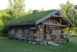 |
The ancient sauna house is a great place for rest and relaxation in Hiiumaa. The house is built of thick logs and has a sod roof. The house has a sauna. |
|
 |
Находится в центре Елгавы у моста через Дриксу, которую опоясывает построенная набережная - променад. В интерьере использованы деревянные элементы. Регулярно проводятся музыкальные вечера. Латышская кухня: Холодный суп, жареное филе камбалы или трески, крестьянский завтрак, картофельные и тонкие блины. |
|


