
| No | Name | Description |
|---|---|---|
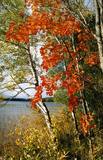 |
This area protects the landscape of the Lielauce hillocks, which are a part of the Eastern Kurzeme highlands. Lake Zebrus and Lake Svēte are in this territory. On the north-eastern shore of Lake Zebrus one can see the Ezerlūķi castle hill. On the eastern shore of the lake is a boating area, along with a viewing tower and a set of information about the area. The territory includes protected biotopes such as stream swamps and swampy forests, along with protected birds and species of bat. |
|
 |
A diverse stand of forest that is bisected by the Vidzeme highway and the Rīga-Lugaži railroad line. This is a place where the largest endangered bird in the world – the European roller – can be found. Between one-quarter and one-fifth of the Latvian population of the crow is found here. This, too, is one of the last nesting places for the green woodpecker.
|
|
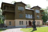 |
On the banks of the Venta River is a treasure of wooden architecture – the so-called Bangerts Villa, which relates to romantic stories and legends and was recently restored. It is said that a man known as Captain Bangerts bought the villa as a gift to present to his Parisian bride. The Kuldīga Administrative District Museum has been in the building since 1940. Since reconstruction, unique wall paintings and other interior design details have been restored, and the flat of the Bangerts family allows people to see how wealthy residents of the city lived in the early 20th century. Also on display are some of the sets of playing cards that have been collected by Jānis Mētra. |
|
 |
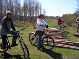
To the East of the Ezermuiža-Dūmele road you will find the bed of the ancient Lake Dieviņezers. It was one of the largest lakes in Kurzeme in the past, being 7.5 km long and 1.6 km wide. A canal was dug in 1838 (Melnsilupe River today), and the water from the lake was siphoned to the sea so as to create fertile farmland. Residents of Ezermuiža have been involved in forestry work since the age when barons ruled the land. Dūmele is connected to Košrags by a lonely forest road that is known as the Bottom Road. A bike route runs down it. The Ziedkalni weekend house is in Dūmele. The "Ziedkalni" homestead in Dūmele offers spa services, cod fishing and accommodations. |
|
 |
Piemājas saimniecība "Rudā lapsa", kas atrodas Ludzas novadā, interesentiem piedāvā iespēju iepazīt laukus, apskatīt mājdzīvniekus, saklausīt dabu, ļauties mierīgai atpūtai. Tiek piedāvātas telšu un piknika/ugunskura vietas. Ciemos tiek gaidīts katrs, kas vēlas atpūsties un izrauties no ikdienas skrējiena. |
|
 |
The Rožlejas farm is in the Džūkste Parish of the Tukums Administrative District, where the Eastern Courlandian highlands interact with the Heath lowlands. The parents of the current owner, Jānis Ukše, began work there in 1989, establishing a natural farm to grow sugar beets and then also wheat. Thanks to thoughtful farming, Rožlejas has, over the past quarter-century, turned into one of the largest grain farms in Western Latvia. The owners have taken active part in EU projects to purchase modern equipment and to build hangars for the storage of grain and equipment. The farm specialises in winter barley and winter wheat, using ~1,200 ha of land for that purpose. |
|
 |
The Crucifix of Ružina is made of wood according to old Latgalian traditions.
|
|
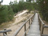 |
The trail climbs up and down along the bluffs of lower River Pilsupe and reveals a fascinating sight of three white dune exposures (the largest is called the White Dune). The trail is 900m long, and the White Dune is ca 20m high. It has formed ca 6000 years ago, in the period of the Littorina Sea which is a foregoer of the Baltic Sea. Here the first Stone Age settlement on the North Western coast of Latvia has been found in 1934 by geologist S. Burhards. In the sand, some 500m from the sea, he found some pottery fragments, a sandstone hone, a piece of flint, parts of bones and an amber bead. He handed the findings over to the National Museum of History. In October 1934, the site was checked by archaeologist E. Šturms, who found the archaeological layer, typical for such settlements, in the landslides of the Pilsupe riverbanks. In 1936 he started larger excavations to continue by 1938. Totally seven, chronologically different settlements were detected and many artefacts found, including fragments of the so called Sārnate and pit-comb pottery, as well as some pieces of corded pottery. Based on these findings, the settlement is dated back to the beginning or middle of the 3rd millenary B.C., and it has been inhabited till the beginning of the 2nd millenary B.C. Especially remarkable are three clay figures in human shape which have probably been used for some religious cult purposes. Since 1993, archaeologist Ilzes Loze has discovered several pit-comb ware culture settlements in large area around Pūrciems village. They are known in research literature as „the Ģipka settlements”. |
|
 |
The nature trail was built in 2003 supported by the WWF, the Latvian Environment Protection Fund, the International volunteering organization supporting conservation initiatives in the United Kingdom (BTCV) involving volunteers from Nīca and Rucava municipal parishes. The trail exposes the surrounding landscapes and related biotopes – dunes, forest, grasslands and bog, as well as bird and animal species found there. On the trail, there is a bird watching tower and two birdwatcher hides. You can see the rivers Paurupe and Līgupe, beaver activity areas, grasslands, black alder forest, spruce forest, floodland, wild horses, aurochs, the Šķilu lime tree, the Holy Grove, the Ezerskolas sacrificial stone, the Pape ornithological field station, the Papes polder grasslands and the Pape lighthouse. There are resting places en route. The trail leads through the historical Ķoņu village with the traditional coastal fishing village architecture of buildings and yards. The trail is 9 km (5 km one way by a gravel road, returning 4km along the coastline). The trail is in the Pape nature park
|
|
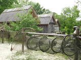 |
This is a very interesting monument to the history of fishing in the region. These areas had docks and areas where fishermen built huts to store their nets and other inventory. The areas also had a social role – men came together to discuss work that had to be done, while women and children wove nets. The huts at Bigauņciems were eventually washed into the sea, and the areas at Ragaciems have been partly destroyed. The ones at Lapmežciems are the ones which are best preserved. One of the net huts has been restored, but the others are in very poor condition, indeed. That may be why you should focus on these huts as you walk along the beach. Make sure that you take some pictures of this historic location. |
|
 |
Vidzemē, Valmiermuižā, 19.gs. celtā ēku kompleksā, ko iekļauj mūra žogs, atrodas Valmiermuižas stallis un Valmiermuižas jātnieku skola. Tajā saimnieko Jurašu ģimene - zirgkopju, zirgu selekcionāru un vetārstu ģimene daudzās paaudzēs. Ir iespēja doties izjādēs, ekskursijās, kā arī tiek rīkotas radošās nometnes bērniem. |
|
 |
The largest city near the Liv Coastline, where visitors will find the Ventspils branch of the Liv Association and the Liv ensemble "Rāndalist." In nearby Tārgale are the Liv ensembles "Kāndla" and "Piški kāndla." |
|
 |
The owners have made sure that everyone can buy fresh and processed fishery products from local producers. During the summer, on the terrace, you can listen to Mazupīte's water, enjoy freshly grilled fish, as well as enjoy particularly delicious cakes, coffee and ice cream. |
|
 |
The former air defence missile base took up a large territory to the South of Pāvilosta in its day, but today that land has been abandoned and degraded. It can be dangerous for visitors.
|
|
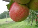 |
This farm is in a lovely location on the western side of the Talsi hillocks, offering a look at Talsi and its area. This is an open farm with grows and processes apples (dried apples, apple chips, apple juice). Visitors are offered an informative tour, with a chance to taste and purchase the products. The farm is in a protected natural area -- the Talsi Hillocks Nature Park. There is an area for tenting during the summer. The owners will teach you to produce a crown from fruit tree branches. The gardens of the farm stretch across the hillocks, and there are several types of local apple trees that are nurtured by the lady of the house. An informative stand alongside the farm features information about the most important values of the nature park. |
|
|
|
Cēsu centrālais laukums – Vienības laukums (20.gs.sākumā – Konventa laukums) – atgādina par Cēsu kauju notikumumiem, kuru nozīme un ikviena dalībnieka ieguldījums aprakstīti devīzē uz pieminekļa “No zobena saule lēca”. Cēsu kaujas 1019.gada jūnijā bija svarīgs Latvijas valstiskuma vēstures pagrieziena punkts, kad apvienotais latviešu un igauņu karaspēks sakāva vācu landesvēru, kas apdraudēja Baltijas valstu pastāvēšanu. Vienības laukums turpina būt par nozīmīgu notikumu liecinieku. 1989.gada 23.augustā daudzu cēsnieku ceļi veda uz Vienības laukumu, kuram cauri vijās Baltijas ceļš. |
|
 8 days
|
This tour offers a look at modern farms that based their work on ancient jobs and skills. Everything that is grown and processed in Latvia's countryside is found at the Central Market in Rīga, where this tour begins. It is one of the largest and oldest markets in Europe. From there you will travel to several farms to taste candy made of natural juices, cheese, grain foods, yogurt and ice cream. You will visit a traditional farm with a technology museum. Each farm will offer a brief introductory tour. Along the way, you will visit the Rundāle Castle and its park and rose garden, which were designed by the 18th century architect Rastrelli and are a true jewel of Baroque and Rococo architecture. In Bauska you will visit City Hall to see a collection of old measuring items, the Bauska Castle and the Bauska brewery. In Lithuania you will visit farms that grow lavender, medicinal plants and hemp. They will be happy to sell their products to you. The town of Anykščiai offers a trail above the trees, and the Krenave archaeological complex is on the UNESCO heritage list. At the conclusion of the tour, you will visit the Trakai lake castle that was built in the 14th and 15th centuries, as well as Vilnius. |
|
 |
Atrodas Cēsu rietumdaļā – pie ceļa, kas ved uz Cīrulīšiem. Piedāvājumā – plašs ēdienu klāsts no brokastīm līdz vakariņām. |
|
 2 days
|
This is appropriate for active hikers who enjoy looking at nature and learning about cultural and historical environments. The hike is down the valley of the most impressive river in the Baltic States – the Gauja, as well as the deep and ancient valley of one of its tributaries – the Amata. Lovely Devonian sandstone cliffs rise above both sides of the rivers. The Līgatne Paper Factory village is an outstanding example of industrial heritage at the European level, with a unique environment from the 19th and 20th century. The Cēsis castle that is at the end of the route was once the mightiest Medieval fortress in Livonia. Route information from Latvijas Lauku forums |
|
 |
Getliņu ekoloģiskais poligons ir Latvijā unikāls piemērs ekoloģiski saderīgu darbības virzienu ieviešanai. Tā energobloka saražotais siltums tiek izmantots siltumnīcu apsildei, kas nodrošina ideālu vidi lauksaimnieciskai ražošanai (puķes un tomāti - lielaugļu tomāti, tumšsarkanie tomāti, aveņkrāsas ķekartomāti) gada aukstajos mēnešos. Poligona teritoriju (zālāju) nogana ar aitu ganāmpulka palīdzību. |
|


