
| No | Name | Description |
|---|---|---|
 |
Based on the tower of a former Soviet army radar installation, there is an 18-metre viewing tower at the Southern breakwater of Ventspils (Medņu Street) today. The tower offers a good view of the port territory, with the sea gate at the mouth of the Venta River and the city beach. Binoculars are available at the tower. It is worth walking down the Southern breakwater to get a better look at the sea.
|
|
 3 days
|
The Liv Coastline involves a series of shoreline villages from Ovīši to Ģipka along the shores of the Baltic Sea and the Bay of Rīga. Like Latvians, Livs are an indigenous population in Latvia, with ancestors who lived here at least 5,000 years ago. They populated extensive parts of Kurzeme and Vidzeme, and the area in which they lived the longest was Northern Kurzeme, on the shores of the Baltic Sea. Today visitors to the Liv Coastline mill meet real Liv fishermen, feel the aroma of smoked fish, enjoy traditional dishes, look at diverse ancient fences, learn about the reticent charm of the local landscape, enjoy the place where two seas, birds and people meet at Cape Kolka, hear the Liv dialect of the Latvian language, see rounded hillocks and swampy areas, visit the Šlītere lighthouse, and see the green-white-blue Liv flag, red bilberries, bird migration routes and blue cows. The oldest evidence of the life of Livs can be found in the Liv centres. The Liv language and culture are still alive in place names, handicrafts, folk costumes, and the world view and lifestyle of people who live in the area. The Liv language and cultural values are part of Latvia's national cultural heritage, and traditional Liv culture is part of the Latvian Canon of Culture. |
|
 |
Saimniecība nodarbojas ar zirgkopību un aitkopību. |
|
 |
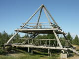
This is the only viewing platform in Latvia which is wheelchair-accessible. From the second level, you can see much of the restricted territory – areas of reeds, some wetlands, dunes and the estuary of the Daugava River. This is a good location for bird-watching.
|
|
 |
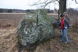
This is the only viewing platform of its kind. It is north of Pāvilosta, between the sea and Latvia’s largest gray dune. The second level of the platform offers a good view of the habitats which surround the dune, as well as the seashore and the largest seashore rock on the shores of the Baltic Sea – the Pāvilosta sea rock. You can also see the northern part of Pāvilosta. When it is windy outside, you’ll see kiteboard riders showing their tricks.
|
|
 |
The farmstead grows apples, strawberries, black currants, red currants, etc., berries and fruits; there is a big selection of processed goods: natural juices, nectars and syrups. There are offered apple, strawberry, red currant, gooseberry, sea-buckthorn and chokeberry saplings; consultations are given for making out a commercial garden and taking care of it. Excursions around the commercially grown plants. |
|
 |
Located at Daugavas Street 58 in Skrīveri, this was the first home of the Andrejs Upītis (1877-1970). It was built in 1908, but the one that is there now was built on the foundations of the first one in 1921. The building houses a museum which features the life and work of the writer, including the writing his great novel “The Green Earth.” There is a garden around the building. In 1952, Upītis gifted the house and garden to the state. The museum offers tours and educational programmes. |
|
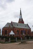 |
Atrodas t.s. Baznīcu kalnā – 18. novembra ielā 66. Apjoma ziņā – lielākais Daugavpils luterāņu dievnams, kuru cēla laikā no 1891. - 1893. g. neogotiskā stilā no sarkanajiem ķieģeļiem (arhitekts Vilhelms Neimanis). 1941. g. baznīcā izcēlās ugunsgrēks un gāja bojā lielākā daļa no tās sākotnējās iekārtas. Turpmāko divu gadu laikā baznīcu daļēji atjaunoja, taču vēlāk tajā izveidoja noliktavu u.c. baznīcai „nepiederīgas” iestādes. 1985. g. ēka vēlreiz cieta ugunsgrēkā. Pagājušā gadsimta deviņdesmito gadu sākumā uzsāka baznīcas atjaunošanas darbus, uzstādīja solus un altāri, kas ir Ogres Amatniecības vidusskolas audzēkņu darinājums. |
|
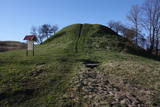 |
Arī Senču pilskalns, Baznīckalns un Velna gulta. Pirmo reizi minēts 1230. gadā kā viens no senās kuršu zemes Vanemas centriem. Ar šo objektu var sākt Abavas senlejas skaistāko skatu apzināšanu. Līdz pilskalna plakumam ved kāpnes, un no tā redzami senlejas vārti un upes ielejas kreisā krasta nogāze, kuras piekājē izvietojusies Jaunkandava.
|
|
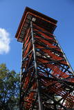 |
Labi redzams no Kornetu centra. Līdz tornim var nokļūt pa taku, kas ved pāri pļavai uz uzlokas pa stāvā Dzērves kalna nogāzi. No torņa paveras viens no skaistākajiem Vidzemes un Latvijas skatiem. Redzams Dēliņkalns, blakus esošie Dzērves un Ievas ezeri, Hānjas augstiene un Lielais Munameģis (acīgākiem vērotājiem). |
|
 |
This medieval saloon is a true Middle Ages saloon situated on the premises of the Ventspils Castle of the Livonian Order, next to which the river Venta flows. The saloon is thoughtfully incorporated in the castle ensemble, the interior design and the foods that are served create a true feeling of the Middle Ages. Latvian cuisine: Mutton soup, roast mutton, plaice filet, herring en papillote, homemade wines. |
|
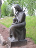 |
Located at the Rūjiena High School, this Kārlis Zemdega sculpture was installed in 1936 in honour of a local teacher, Jūlija Skuiņa, who drowned in 1936 at the age of 24. There are various legends about her death, one of which talks about a tragic love story involving the Rev Roberts Slokenbergs. |
|
 |
This area protects the landscape of the Lielauce hillocks, which are a part of the Eastern Kurzeme highlands. Lake Zebrus and Lake Svēte are in this territory. On the north-eastern shore of Lake Zebrus one can see the Ezerlūķi castle hill. On the eastern shore of the lake is a boating area, along with a viewing tower and a set of information about the area. The territory includes protected biotopes such as stream swamps and swampy forests, along with protected birds and species of bat. |
|
 |
Although out of 104 village houses 97 were destroyed during World War I, at the end of the 30ies of the 20th century Lapmezciems "recovered" fast, and one of the most powerful coastal fishermen cooperatives in Latvia were operating in it. During the Soviet times here one of the largest fishery collective farms – "Selga" was founded here, the blocks of which can be seen at the mouth of the Siliņupe River. Today Lapmezciems is a popular area for summer cottages, a recreation and bathing place. As an interesting history monument of fishery the sedum of Lapmezciems is available for viewing – it is the former wharf of fishing boats, where fishermen built nest cabins and stored their equipment. Between Pīlādži Street and the left bank of the Siliņupe River in the 3rd and 2nd millennium BC settlement of fishermen and hunters were located, where a memorial stone is erected. This is the most ancient known location populated by humans within the territory of Kemeri National Park. Part of the findings is displayed at Lapmezciems museum, where local history research exposition is formed and materials about Finnish Jeager fights within the territory of Klapkalnciems are gathered. |
|
 |
К северо-востоку от Мазирбской лютеранской церкви – в полемежду храмом и домом «Пакални» видны два чумных камня. На поверхности бóльшего был высечен (сейчас стерся) текст о ливах, которых одолел король Швеции Карл IX и чума. Сбоку на большой камень опирается второй (самый маленький) чумной камень, который в свое время был установлен у близлежащих домов. Стертый текст рассказывал об армиях, ходивших по Курземе, о голоде и чуме. Третий – Большой чумной камень находится заМазирбским имением священника. Высеченный на нем текст (еще немного просматривается) повествует будущим поколениям о местном священнике (умер во время чумы) и о создании пастората в Сикрагсе. Одновременно камень является памятником шести пасторам обширной окрестной общины. Все три камня повествуют о Большой эпидемии чумы 1710 года, и тексты высечены на них в период с 1711 по 1734 год. |
|
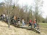 |
This path is found on the right bank of the ancient Abava river valley. The visitor will be able to view places where underground streams create wetlands, various kinds of meadows, a stand of juniper bushes, etc. The area is “managed” all year long by “wild” cows. The shore of the ancient valley can be climbed (some 200 steps), and the view is magnificent. It is recommended that the trail be visited in the company of a knowledgeable guide. There is a shorter path that is 600m long, along with a longer one that is more than a kilometre in length. It will take an hour or so to traverse it. Objects are found in the ancient Abava valley nature park.
|
|
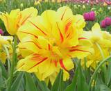 |
This farm grows tulips and has nearly 400 different types of bulbs. A tulip festival is held each spring, and bulbs can be purchased in the autumn. Also on view are a pony, goats and rabbits. The farm also offers cakes, pastries and other treats. |
|
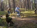 |
Brīvdienu mājas "Korķi” apkārtnes priežu mežā ir izveidota Jāņtarpiņu taka. Ideāla vieta aktīviem sēnotājiem un ogotājiem. Savukārt saules un jūras cienītāji pa šo taku 5-10 minūšu gājienā nonāks Vitrupes pludmalē, kur varēs baudīt sauļošanās un peldēšanās priekus.
|
|
 |
Saimniecība specializējas uz dažādu dekoratīvo stādu audzēšanu nelielos apjopmos. Sezonas laikā pieejamas arī svaigas krūmmellenes, smiltsērkšķi, cidonijas, augļi un ogas. |
|
 3 days
|
On this tour, you will see the most beautiful places and towns in the Vidzeme region and Gauja National Park such as Sigulda with the River Gauja valley, the medieval old town of Cēsis, and Valmiera. You will feast on the Miller’s Lunch, visiting a working windmill, explore a herb and vegetable garden by a medieval castle, taste hemp butter, and Valmiermuiža local brewery beer. You will taste the “green cheese”, a sparkling birch sap drink, and can buy delicacies made from locally grown garlic. |
|


