
| No | Name | Description |
|---|---|---|
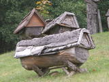 |
Das bekannteste Museum der Geschichte der Bienenzucht Litauens mit den Bienenhäusern verschidener Arte, der Arbeitsmittel der Bienenzüchter, Holzskulpturen und Hönigankauf. |
|
 |
This farm produces tomatoes, apples, pears, raspberries, strawberries, etc. Visit the farm in the spring to see blooming pear and apple orchards and fields of raspberries. During the autumn you can help to harvest fruits with special "kangaroo pouches" and wheelbarrows. |
|
 |
In the very heart of Mulgimaa there is a family brewery that respects local foods and beverages. Visitors can observe the beer making process and taste different sorts of Mulgi beer. |
|
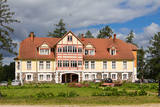 |
Close to Otepää, in a very beautiful place, surrounded by woods and hills, Canterville loss is waiting for you. A great place to relax with your family. Large playground for children. The restaurant serves both romantic meals and lunch during workshops. |
|
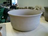 |
This crafts centre is located at the former Svēte Estate, and it organises creative workshops. You can purchase ready-made or commission original ceramic ware. |
|
 |
A cosy café in the centre of Liepāja. Offers coffee, delicious cakes and great food. Every morning at around 5 a.m., the croissant master starts to work in order to have fresh croissants ready to serve for 9 a.m. |
|
 |
A place in the centre of Tartu where one can enjoy small and light fish & chips style meals made from the products of Lake Peipus. The small shop combines Peipus' area dining experiences with modern cuisine, using only the best local products. Very popular choices are fish & chips made from pike perch fillet, juicy burgers, as well as wraps. |
|
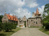 |
Cesvaine was first mentioned in written sources in 1209. For each traveller in Latvia, the town is associated with the family of Baron Woolf, who bought the Cesvaine estate in 1815. Cesvaine experienced the economic boom after establishment of Plavinas Gulbene railway. Town suffered significantly during the World War II. At the end of 2002, the Cesvaine Castle was struck by the tragedy - a fire, which damaged most of the castle. Cesvaine Castle is "recovering" by means of large public, state and local government support and still keeps the status as a significant tourism attraction in a scale of Vidzeme and Latvia. |
|
 |
Medinski Vincīši boulder also called Magoņkalns (Poppy hill). Red rapakivi granite boulder is found
in the tree cluster only 40 m to the left of Jaunviļāni – Medinski road and about 40 m from the right side of
the river Malta. The boulder is 6,6 m long, 5,4 m wide and 3,3 m high. The circuit of the boulder is 20 m
and the volume 40 – 45 m3.
|
|
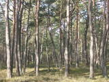 |
Ap 100 gadus veca priežu audze, ko iesēja pagājušā gadsimta sākumā. Sēklu materiāls bija nācis no kādas Vācijas (Darmštatē) sēklu tirdzniecības firmas. Mūsu klimatiskajos apstākļos priežu stumbri izauga līki un kroplīgi. Savdabīgā audze labi redzama no šosejas malas.
|
|
 |
Ethnographical guesthouse in the historical Paenese, Muhu island
|
|
 |
We recommend that you walk through the town of Kandava not only to enjoy the charm of a small town, but also to find fantastic viewing locations where you can see the town and the shores of the ancient Abava River valley from the Kurši (Ancestor) castle hill, Lielā Street, the Bruņinieki castle hill and Zīļu Street (School Hill), as well as from the area of the Ozolāji open-air stage.
|
|
 |
The open-air pizzeria not far from Valmiera in Beverina district. It is an opportunity to spend time in the countryside, relax and take part in making real Italian pizza, where everyone has a chance to make a pizza according to one’s taste, baking it on open fire in a wooden stove. Available clear water and Italian wine, coffee and tea. Apart from pizzas, it is possible to buy tiramisu, having ordered it beforehand. |
|
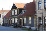 |
Painted in dark colours, this building dates back to the 17th century (the square around it is cited in documents). The city’s first prison was in the cellar of the building, and the square was historically a place for residents of the city could gather and suffer punishments. A pole of shame was at the south-eastern corner of the square. The building now houses the Kuldīga Tourism Information Centre and a workshop for weavers. Visitors can purchase products and souvenirs from Kurzeme and watch weavers at work. |
|
 |
Traķu pussalas pils austrumu mūrim pieguļ ar mežu apaudzis iespaidīgs pilskalns (uzved koka kāpnes) – t.s. Upurkalns, kurā pirms mūra pils celtniecības stāvējusi koka pils. 1779. g. dominikāņu mūki sagrautās Pussalas pils vietā uzsāka baznīcas celtniecību. Jau vēlāk – 1822. – 1823. g. vienā tās daļā uzcēla dominikāņu klosteri, bet otrā – kapelu. 1990. g. šeit izvietoja Traķu vēstures muzeja administrāciju, bet 2005. g. kapelā izveidoja Sakrālās mākslas izstādi. 2011. g. ēku kompleksā notika vērienīgi rekonstrukcijas darbi. |
|
 |
Ģipka is a village that once was the site of the first maritime school in Kurzeme. It was opened in 1869, just a few years after a similar school in Ainaži. This was a Category 2 maritime school, which trained helmsmen for long-distance trips and captains for short-distance trips. The school was moved to Mazirbe in 1894. Before the maritime school, the building housed a different kind of school, and a second floor was added in 1867 specifically for the maritime school. Today this is a residential building. During 28 years, the school trained more than 200 professional sailors, and it was of great importance in facilitating ship building in shoreline Liv villages. (Source: Roja TIC) |
|
 |
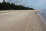
Camping "Klintis" on the very shore of the sea near Veczemju cliffs offers parking, tents and picnic places with benches, tables, grill, the opportunity to buy firewood. There are well-equipped camping houses, places for campers, showers and WCs available for camping guests. In the territory of the camping there is a restaurant "Rankulļrags" and a summer cafe. There is a playground for younger guests. |
|
 |
The cafe is situated in Sabile, where you can eat fast and tasty food. Banquets up to30 people. |
|
 |
Lina, vilnas apģērbu šūšana, galdautu, dvieļu, jostu u.c. tekstilizstrādājumu šūšana. Tērpu darināšana nav tikai darbs, bet arī aicinājums. Tas palīdz izgatavot vissarežģītākās tērpu konstrukcijas. Nemitīgā zināšanu papildināšana kursos ļauj veiksmīgi dzīvot līdzi mainīgajām modes prasībām. Paralēli individuālajiem pasūtījumiem tiek izgatavoti gan apģērbi, gan citi šūtie izstrādājumi tirdzniecībai. |
|
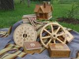 |
The workshop and “Dream Hut” exhibition hall at this venue offer a look at turned wood products such as candelabras, dishware, beer steins, vases, glasses, mortars and pestles, small boxes, wooden paintings, etc. You can commission and purchase products and watch the master at work. |
|


