
| No | Name | Description |
|---|---|---|
 |
Baltijā lielākās HES celtniecību uzsāka 1961. g., bet pabeidza 1966. g. Tajā uzstādīto 10 hidroagregātu projektētā jauda bija 825 MW. Pļaviņu HES tiek uzskatīta par unikālu, jo pirmoreiz HES būvniecības praksē tā konstrukcija tika balstīta uz mālsmilts un smilšmālu gruntīm ar maksimālo spiedienaugstumu - 40 m! Pļaviņu HES ēka ir apvienota ar ūdens pārgāzi, zem kuras atrodas Latvijas garākais tunelis - Enerģētiķu iela. 20. gs. deviņdesmitajos gados Pļaviņu HES rekonstruēja un tagad tās jauda ir sasniegusi 870 MW. Apmeklētāji var iepazīt mašīnzāli, skatu laukumus un HES maketu. |
|
 |
Hauptstadt von Hiiumaa. |
|
|
| ||
 |
In Soviet times, the border guards of Ventspils established a major complex of buildings, open areas and various objects. Most of these are no longer in use, and the area is not under guard.
|
|
 |
From the 6th century until the 8th century instead of the current Grobina the largest known Scandinavian trade and warrior colony in the Baltic States was located. Settlers from the inlands of Gotland and Sweden established their settlement at the hillock that was then located at the bank of the navigable Alande River. It is believed that the Cours Castle – Seeburg mentioned in the chronicles of the 9th century was located exactly here. After the loss of the order castle in the 13th century Grobina became the centre of the region. The most ancient construction of the city was formed around Lielā Street, as well as around Saules and Parka Streets. |
|
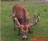 |
he wetland meadows that are around the Pededze River are the site of this 200 ha farm with some 350 red deer, other deer and wild boar. There are towers from which you can watch the graceful animals, and there are ponds for commercial fishing. Please contact the owner well in advance for a tour. |
|
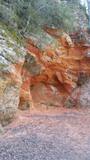 |
Sarkanās klintis savu vārdu ieguvušas pateicoties sarkanajiem iežiem. Tieši sarkanā ir mīlestības krāsa, tāpēc sarkanās klintis ir romatiska pastaigas vieta mīlniekiem. Smilšakmens klintīs redzamas plaisas, kas sašķeļ sarkanīgos iežus, radot neparastu dabas mākslas darbu. To virsma ir diezgan izrobota, kas veido klintīs nelielas alas un nišas. Sarkanajās klintīs ir arī daudz dažādu avotiņu. Pazīstamākais no tiem ir Rūcamavots. Tam ir šāds nosaukums, jo tas, nākot ārā no zemes, izdod nelielu rūkoņu. |
|
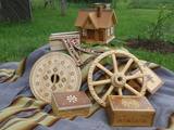 |
The workshop and “Dream Hut” exhibition hall at this venue offer a look at turned wood products such as candelabras, dishware, beer steins, vases, glasses, mortars and pestles, small boxes, wooden paintings, etc. You can commission and purchase products and watch the master at work. |
|
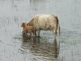 |
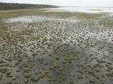
The shallow and mostly overgrown (65% of its surface) Lake Engure is one of those Latvian lakes which are most favoured by birds. It is a location which is governed by the Ramsar Convention on Wetlands, and 186 species of nesting birds have been identified there. The area is also distinguished by great botanical diversity (more than 800 kinds of plants). The coastline varies between sandy beaches and seashore meadows. There are forests, fishing villages and damp areas which ensure a great diversity in landscapes and species. The flood-land plains of the lake and the sea are grazing grounds for wild livestock – horses, blue cows, etc. Several bird-watching towers are open to visitors, as is the Orchid trail. The Centre for Ornithological Research is located on the eastern bank of Lake Engure. A unique floating house built by ornithologists is located on the lake. The territory is appropriate not just for holiday-makers, but also for hikers, bicyclists and bird-watchers. A leisure area and a small exhibition are located close to the ornithological research centre. |
|
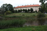 |
One of the largest castles in Kurzeme, this building has been preserved in fairly good shape. Work on its began in the mid-13th century, and it was commissioned by the heads of the Dome Cathedral in Rīga. In 1434, the estate was bought by the bishop of Kurzeme. The Maidel and Osten-Sacken dynasties owned it from the 16th to the 20th century. The Dundaga Castle burned down twice and has been rebuilt many times. The last reconstruction was in 1905, after the castle was burned down during the revolution. Of interest on both sides of the castle’s door are stone carvings of a knight and a bishop. In recent years, the hotel in the castle has been renovated, as has the second floor hallway and a terrace that is popular for weddings. There are many legends about the castle, including one about a wedding of elves and another about the Green Lady. Today the building houses the Dundaga School of Music and Art, a hotel, party rooms, the Dundaga Tourism Information Centre and various exhibitions. It is worth finding a guide to tour the castle. Groups of tourists can also order tastings of local foods. |
|
 |
The farm makes goat’s milk cheese and other goat’s milk products. Goats, sheep, rabbits and domestic birds are bred here. You can purchase products by ordering in advance, excursions on the farm are organised during summer. |
|
 3 days
|
The tour starts at Jaunmokas Castle estate, where you will also find the Forest Museum. The pride of the castle is its unique painted tile stove (beginning of the 20th century) made of 130 painted tiles featuring 50 different views of the cities Rīga and Jūrmala. The Forest Trails runs along smaller tracks through the Austrumkursa Uplands, the valley of the river Slocene, along Lake Sekļa and Lake Jumprava to finally reach the town of Tukums. Well, the town takes pride in its pots, planters and flower beds with blooming roses along its streets. Next, the route meanders through forests to the demanding hillock of Milzkalns and Lake Valguma, where you will find the barefoot trail and a secluded art space within the woods. The Forest Trail continues to make a stopover at the Ķemeri National Park. The park is dedicated to protection of wetlands, since it is home to one of the largest marshlands of Latvia – the Great Ķemeri bog. As to the town – Ķemeri – it is the former balneological and sulphur springs resort. The tour ends in the village of Bigauņciems, where the Forest Trail joins with the Baltic Coastal Hiking Route (E9 European long distance path). Optionally, one can take a detour along the Lake Sloka trail with its bird-watching tower or pay a visit to the “Forest House” – the visitor’s centre of the Ķemeri National Park. |
|
 |
Ideja par "DA'ZIEPE" radās iedvesmojoties no Amatas novada dabas un idejas par pilnvērtīgu pieejamo resursu izmantošanu. Ziepes tiek gatavotas no liellopu vai briežu taukiem, augu eļļām un ziepju zālēm, kā arī papildinātas ar dažādām ēteriskajām eļļām un dabīgajiem aromātiem. |
|
 1 day
|
Guided wilderness experience day-trip combines bog shoeing and canoeing. First is walking through the forest and reaching the largest peat-bog in Estonia – Kuresoo. Wear bogshoes and walk on the wild landscape, followed by wilderness lunch. The trip ends with a relaxing canoe trip along Soomaa meandering rivers. |
|
 |
This venue offers tastings of honey beer and honey. You can buy all kinds of beekeeping products, natural wax candles and various types of honey beer. |
|
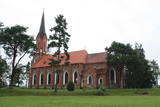 |
The Velēna Lutheran Church is at the crossing of the Smiltene-Gulbene-Lizums roads. It is said that the roof of the first wooden church at this location had a peat moss roof. The organ from the Sauer company still works, and it is one of the best organs in Latvia. The organist offers guided tours of the church. |
|
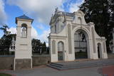 |
The Krāslava Catholic Church was built between 1755 and 1767 after a design by the Italian architect A. Paracco, and it is considered to be Latgale’s most outstanding Baroque monument. The interior can be toured, and you can also visit the restored cemetery where members of the Plater family of noblemen are buried. |
|
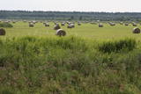 |
Open landscape area within farming lands on both banks of Uzava River about 10 km before it flows into the Baltic Sea. There is a good open view over the area from the Vendzava-Ziri road going through the nature park. Protection of migratory birds and corncrakes has been one of the main reasons for establishment of the nature park. Bird watching is possible from the road Vendzava-Ziri during migration period in spring and fall. There is no tourist infrastructure in the nature park.
|
|
 |
Svētkalnā atradusies krustnešu nocietinātā pils. Zemgaļiem to nebija pa spēkam ieņemt, tādēļ, nodedzinādami savu pili Tērvetes pilskalnā (1286. g.), tie aizgāja uz Raktes (Žagares) novadu Lietuvā. Kad Svētkalna nocietinājumi bija zaudējusi savu militāro nozīmi, krustneši to nojauca. 1701. g. Ziemeļu kara laikā Svētkalnā atradās zviedru armijas nocietinātā apmetne, no kā arī cēlies vietvārds. Domājams, ka pirms tam šajā vietā atradusies seno zemgaļu svētvieta. No Svētkalna paveras viena no skaistākajām un biežāk fotografētajām Tērvetes ainavām. |
|
 |
The tower on the eastern shore of Lake Engure (next to the meadow for wild cattle, accessible from the side of Bērzciems) offers a view of the reeds, small islands, Great Island, cows and horses of the north-eastern part of the lake. The tower on the northern shore of the lake (accessible from the side of Mērsrags) offers a look at the boating facility and the very overgrown northern part of the lake. The tower at the north-western shore of the lake (accessible from the side of Ķūļciems) shows the Apaļrova island (a footpath), stands of juniper, the boating facility, and the mosaic-like landscape of the lake itself.
|
|


