
| Nr | Nosaukums | Apraksts |
|---|---|---|
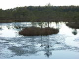 |
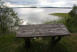
Teiču dabas rezervāts – neskarta teritorija, purvi un putni. Tā ir nozīmīga putnu atpūtas vieta pirms sezonālajām migrācijām. Šeit vienkopus iespējams ieraudzīt līdz 1500 dzērvju, un līdz 8000 zosu. Purvā sev piemērotu vietu saviem riestiem atraduši arī rubeņi, tādēļ, ja agrā pavasarī esi netālu, noteikti ieklausies, varbūt sadzirdēsi šo majestātisko putnu rubināšanu. Takas apmeklējams iespējams tikai Dabas aizsardzības pārvaldes darbinieka pavadībā no 1. jūnija līdz 31. oktobrim. |
|
 |
Meža vidū, klusumā atrodas „Mākoņmalas”. Maģiska vieta , kur var baudīt SPA procedūras un pirts rituālus, iegūt zināšanas maģiskās un netradicinālās praksēs, kā arī pabūt vienatnē ar dabu, uzlabot veselību, izbaudīt „īso atvaļinājumu steidzīgajiem un aizņemtajiem”. „Mākoņmalās”saņemsiet restartu gan miesai, gan dvēselei. Pēc procedūrām ir iespēja izbaudīt dziļo naktsmiegu mūsu mājās un izgaršot agrās brokastis uz terases, vērojot meža dzīvnieku rīta rituālus un dabas skaistumu. Rītu izbaudīt var dodoties nūjot vai parastā rīta pastaigā pa mežu, lai satiktu stirnas un citus meža iemītniekus. |
|
 |
Viens no svarīgākajiem pieturas punktiem Ziemeļkurzemes piekrastē, kur var iegūt plašu informāciju un priekšstatu par novada un piekrastes vēsturi, kultūrvēsturiskajām vērtībām, burinieku būvi, zvejniecības tradīcijām, šīs puses ļaudīm, viņu darbu un nopelniem. Muzejs Rojā dibināts 1968. gadā. Pašlaik apskatāmas patstāvīgās ekspozīcijas par Krišjāni Valdemāru, Rojas jūrskolu un burinieku būvi 19. gadsimtā. Izveidota arī ekspozīcija par zivju apstrādes vēsturi no 19. gs. līdz mūsdienām, Līvu krastu, padomju laika pienesumu piekrastes attīstībā. Bez pamatekspozīcijas apskates vēl iespējams iepazīties ar trim kurzemniecēm, kuras pārstāv dažādus vēstures posmus: Mildiņa – vienkārša zvejnieku sieva no „jūrkantes", Pauliņkundze no burinieku laikiem un Anna Petrovna no padomju laikiem. Viņas atraktīvi iepazīstina ar muzejā neeksponētiem priekšmetiem un kurzemnieku „nešpetno" humoru. (Avots: Rojas TIC) |
|
 |
Spa viesnīca atrodas skaistā vietā, netālu no Lohjas ezera, mierīgas dabas ieskautā vietā. Šeit var iznomāt velosipēdu vai /un laivu, doties uz sporta zāli, spēlēt mini-golfu, peldēties un daudz ko citu. |
|
 |
„Ilzenberga muiža” – pirmā un Baltijā lielākā saimniecība muižā. Saimniecībā, kurā darbs noris harmonijā ar dabu, var redzēt un iegādāties dažādu veidu maizi no dabīgā ierauga, mājputnus un to olas, ekoloģiskās ganībās izaudzēto liellopu gaļu, pienu un to produktus, dīķos audzētās zivis, tradicionāli audzētās dārza veltes, dažādus dārzeņus, ekoloģiskajā muižas apkārtnē iegūto bišu medu, kā arī dažādus žāvētus, skābētus un kūpinātus produktus. |
|
 |
Līčainā un pussalām bagātā Ciriša ezera (atrodas Ciriša dabas parkā) klājs rotājas ar vairākām salām, no kuras lielākā – Upursala savā koku lapotnē ir paslēpusi Upurkalnu - senu latgaļu pilskalnu. Tā pakājē konstatētas senas apmetnes liecības un atrastas trauku lauskas, akmens kalts un citi priekšmeti. Salas austrumdaļas piekrastē izveidota laivu piestātne, bet apkārt salai - labiekārtota dabas taka. Pilskalnā uzvedīs koka kāpnes. Laivu var sarunāt viesu namā „Aglonas Cekuli”. |
|
 |
Atrodas Baznīcas ielā 10. Skaistā ēka ir viena no nedaudzajām 17. gs. celtnēm, kas būvēta koka pildrežģa tehnikā (restaurēta 1986. g.). Kurzemes hercogistes laikā tajā atradās pirmā zāļu tirgotava. Apskatāma no ārpuses. |
|
 |
Kafejnīca "Gaļas nams" atrodas Jēkabpils centrālajā daļā. Cep picas, smalkmaizītes, kūkas, tortes un kliņģerus. Piedāvā kūpinājumus, brieža un mežacūkas delikateses, vietējo mājražotāju un zemnieku produktus. |
|
 |
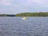
Nacionālā parka galvenā ainavas dominante. Ezers ir ~ 8,4 km garš un līdz 3,3 km plats. Tā austrumu krasti pārsvarā ir ar mežiem apauguši, ziemeļrietumu krasts – purvains, bet rietumu krastā parādās apdzīvotas sētas un simpātiskā Plateļu (Plateliai) pilsētiņa, kur meklējamas skaistākās skatu vietas. Ezera krastos ir labi attīstīta infrastruktūra - tūristu mītnes, ēdināšanas uzņēmumi (Plateļos), ūdenssporta un atpūtas inventāra noma. Ūdens dzidruma dēļ, Plateļu ezeru ir iecienījuši zemūdens niršanas entuziasti. Ezerā ir vairākas salas, no kurām interesanta ir Pils salas (Pilies sala), uz kuras no 15. – 16. gs. atradās muiža. Pastāv uzskats, ka senie Plateļu apkārtnes iedzīvotāji sākotnēji ir dzīvojuši uz salas, kuru ar krastu savienojis uz pāļiem celts tilts. Jāpiemin, ka 15 gs. pirmoreiz pieminētā Plateļu pilsētiņa atradusies uz Šventorkalņa (Šventorkalnis) kalna. Apkārt Plateļu ezeram ir izveidots ~ 24 km garš velomaršruts. Tā ir ļoti laba iespēja iepazīt parku videi un ceļotāja veselībai draudzīgā veidā. |
|
 |
Ziemeļu forti, kas atrodas pašā Baltijas jūras krastā (daļēji noskaloti) ir tikai neliela, bet ļoti iespaidīga daļa no unikālās Liepājas fortifikācijas sistēmas, kas pilsētu apjož visā perimetrā. Fortu pazemes bunkuri veidoti divos stāvus un tos vērts izstaigāt zinošā Karostas gida pavadībā (organizētas ekskursijas no Karostas cietuma). Blakus fortiem atrodas auto stāvlaukums. Esot Ziemeļu fortos, vērts nostaigāt ap 4 km garo jūras krasta posmu līdz Liepājas Ziemeļu molam, kur jūras krastā un jūrā ir redzamas divas krasta aizsardzības baterejas ar ļoti iespaidīgiem skatiem.
|
|
 |
Purmaļu laukakmens ir lielākais laukakmens Rēzeknes novadā un
viens no divdesmit lielākajiem Latvijā, atrodas stāvā nogāzē koku un
krūmu ielokā. Akmens ticis postīts, izlaužot robus, kas tagad veido lielus
pakāpienus. Akmens iegūlis stāvā nogāzē, un tas vēl vairāk izceļ tā
ainaviskumu. Apkārtmērs 18,5 m, augstums 3,2 m, garums 5,6 m, platums
4,7 m, virszemes daļas tilpums ap 30 m3.
|
|
 |
Lauku sētā, kas atrodas Daugavas krastā, audzē dažādas ogas, ābolus un bumbierus. Viesi var iet dārzā, cienāties un iegādāties izaudzēto produkciju. |
|
 3 dienas
|
Šis trīs dienu maršruts piedāvā dažādas kulinārās pieredzes piedzīvojumus. Brauciens ar autobusu ir kombinēts ar braucienu ar velosipēdu Kihnu salā, lai apciemotu vietējās saimniecības un ieskatītos to produkcijas tapšanā, izmantojot pašu saimniecībās audzētās izejvielas. Jums būs iespēja izgaršot sidru, zivis, ārstniecības augu tējas, alu, piena produktus, kā arī dažādus konditorejas izstrādājumus. Garšu piedzīvojuma laikā jūs izbaudīsiet ne tikai Igaunijas, bet arī Krievijas tradicionālos ēdienus vairākās vietējo mājražotāju saimniecībās; ēdieni tiek uzskatīti par vietējo kulinārijas mantojumu. |
|
 |
Viens no skaistākajiem Ventas upes ielejas un tās pietekas – Šķērveļa posmiem ar izteiktu dziļu upju ieleju un tās sānu gravu sistēmu, kurā dažviet redzami dolomīta un smilšakmens atsegumi un strauji upju posmi (straujteces). Ventas krastos atsedzas arī izmēros lielākie Kurzemes pamatiežu atsegumi – Ātraiskalns un Gobdziņu klintis. Netālu no lieguma atrodas Lēnu katoļu baznīca. Šobrīd lieguma teritorijā nav nekādu labiekārtotu tūrisma elementu – taku, atpūtas vietu u.c. Venta posms no Nīgrandes līdz Kuldīgai ir populārs ūdenstūrisma galamērķis. |
|
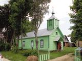 |
Tāda paša nosaukuma ciema dienviddaļā paceļas no koka (zaļā krāsā) 19. gs. celtais dievnams, kas apskatāms no ārpuses. |
|
 |
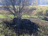
Atrodas 0,5 km ziemeļaustrumos no Dzērbenes baznīcas, ceļa otrajā pusē. Vizuāli izteiksmīgs pilskalns ar 50 x 50 m lielu plakumu, kura kultūrslānī atrastas vēlā dzelzs laikmeta apmetnes atliekas. Pilskalna rietumu nogāzē ir izveidots ceļš, pa kuru nonāksim līdz tā plakumam ar estrādi. |
|
 |
SIA „Arosa-R” ir ģimenes uzņēmums, kurš nodarbojas ar lielogu krūmmelleņu un to stādu audzēšanu, arī stādu tirdzniecību. |
|
 11 dienas
|
The tour begins in Riga with its Art Nouveau district and Old Town. Make your way to Sigulda by train. A hilly road passes Gutmana Cave, Turaida Castle and Krimulda Castle which stand on the hillsides of the Gauja river valley. The road continues to Limbaži, which is a typical Latvian provincial town. Further on you reach the Baltic Sea coast and Salacgriva, which is famous for its fishing traditions and lamprey. Outside Salacgrīva town there are rare coastal meadows and lagoons. After crossing the Latvian-Estonian border point, the road winds through old coastal villages - Ikla, Treimani, Kabli and Häädemeeste before rejoining the Via Baltica. At Pärnu explore Ruutli pedestrian street and the old fortifications. It is time to cross to the islands - the route passes through the small island of Muhu. Visit the local fish cafe at Livi and ethnographic fishermens’ village of Koguva. Then the route leads to Saaremaa island over a causeway. The main sites on the route are 'Valjala maalinn' – one of the most attractive hill forts in Estonia, the Valjala church, and meteorite craters of Kaali. By bus you head to the Estonian capital, Tallinn, charming with its medieval Old Town. From there take a tour of a former Soviet submarine base at Paldiski, a memorable reminder of recent history. |
|
 |
Priekules luterāņu baznīca celta baronu laikos ap 1680. gadu. 1792. gadā tā piedzīvojusi jaunu pārbūvi un ieguvusi tagadējo izskatu. No 2005. gada 6. augusta visiem interesentiem ir pieejams baznīcas skatu tornis, no kura savulaik savu vēsturisko lidojumu ir sācis leģendārais Priekules Ikars. Baznīcas tornī Sakrālā tūrisma projekta ietvaros ir ierīkotas savdabīgas kāpnes, par kurām uzkāpjot torņa smailē kaut nedaudz iejutīsieties Ikara lomā un aplūkosiet pilsētu no augšas. |
|
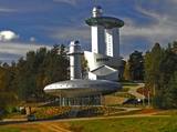 |
Vienīgais šāds muzejs Baltijas valstīs. Tā mērķis – parādīt cilvēka (un lietuviešu tautas) saikni ar kosmosu. Izglītojošas programmas, mitoloģiskie akmeņi. |
|


