
| No | Name | Description |
|---|---|---|
 |
The owner of this farm produces ecological vegetables, fruits and berries, and two protected breeds of cows. She chairs a club for lovers of horses and breeds local breeds of horses. The owner has a horse breeding museum with more than 1,000 exhibits. She also organises various celebrations for the Assumption of Mary festival, etc. |
|
 |
Pitas ir pēc inovatīvas žāvēšanas tehnoloģijas radītas augļu, ogu un garšaugu garšvielas, kuras ražo mājražotāja Lorita Miķelsone. Mājražotāja labprāt ļaus nodegustēt un iepazīstinās ar Pitām jebkuru interesentu, uzņemot apmeklētājus Skaisto un praktisko ideju dārzā Dobelē. |
|
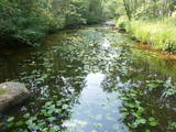 |
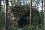
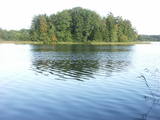
This territory protects a lime outcrop found on the shores of the lower reaches of the Zaņa River. There is a path for active hikers which begins at the Zaņa mill (1864, rebuilt 1890, shut down 1960). The path weaves its way along the steep shores of the little river, heading toward its mouth.
|
|
 |
Meklējama pilsētas centrā - Tirgus laukumā 11. Dievnams uzcelts 1886. g. Ēkā atrodas vairāki nozīmīgi mākslas pieminekļi – gleznas, krucifikss (18. gs.) u.c. Baznīcas dārzā apskatāma skulptūra “Latgales māte” (tēlnieks B. Buls) un piemineklis politiski represēto piemiņai (tēlniece V. Dzintare). Baznīca ir apskatāma arī no iekšpuses. |
|
 |
The café is in the market square of Vecpiebalga, opposite the Lutheran church. It works with local farmers and sells products from a local smokehouse. |
|
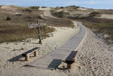 |
Die Dünen nördlich Pervalka über dem ehemaligen Dorf Negeln. Eine 9 km lange Strecke mit den wüstenartigen Landschaften. Stegpfade. |
|
 7 days
|
Ventspils is one of the most afluent Latvian towns with excellent infrstructure, well- restored Old town and Livonian Order Castle, clean and well equipped white sandy beaches, promenade, arty fountains, flower sculptures, manicured parks and various attractions.Whole town is family oriented but kids particularly enjoy the Blue Flag beach with different swings, climbing and sliding options as well as Kids Town with activity zones for different age groups. A short trip by "Mazbanitis", the narrow-gauge steam engine is a special attraction for kids as well as adults. Walking and cycling routes as well as trip on the tourist boat give a good chance to explore the town and coast. Water pleasures can be fully enjoyed at indoor or outdoor acqua parks. We suggest two self-drive excursions in vicinity featuring scenic sea coast, traditional fishing villages where smoked fish can be bought from fishermen, Slitere National Park with beautiful view from its lighthouse, charming Kuldiga with its wooden arhitecture. Driving there is easy since roads are rather empty. |
|
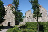 |
Exploring of Sigulda can be started with a visit to Sigulda castle ruins. The construction of the castle was begun by the Knights of the Sword Order in 1207, but in 1236 it was rebuilt for the needs of the Livonian Order. Sigulda castle suffered much from the wars in the second half of the 16th century and in the beginning of 17th century. During the Northern War, it is burned down and is no more restored. Today south-western building of the convent and the tower of the main gate, behind which is the inner forefront of the castle with open air stage, which offers impressive views over the Gauja valley. Currently the reconstruction of castle ruins is in progress. Construction of New castle (owner - Prince Kropotkin) in the South of the Sigulda took place from the 1878 until 1881. From 1923 - 1940 the building was the Palace of Writers, but during the Soviet years - Cardiology sanatorium. Since 2003 Sigulda district council is located there. The manor complex includes wooden house (middle of 19th century), which was Kropotkin's family home, barn (turn of the 18th - 19th century), gardener's house (19th century) and a stone fencing (19th century.) If we make our way from New Castle in a north-eastern direction, after almost 2 km we will reach Vejupite ravine. There you can see the shallow (3.6 m) but high (6.1 m) in Peter's Cave and deep Pucu ravine with Krauklupite. At the conjunction of ravines of both streams rises a Satezele hill fort (plateau 90 x 75 m), where in the beginning of 13th century was the oak castle of Liv land chief (eldest) - Dabrelis. Near can be found Krauklu gorge - ravine of Vejupite left bank, with 11 m high sandstone walls and 5.2 m deep Krauklu cave. At the conjunction of Vejupite ravine and Gauja valley columns Paradise (Gleznotaju) Hill - a very picturesque place, painted and photographed since old times! The Paradise Hill can be reached with a electric vehicle. In the west part of Sigulda is located Ferris wheel (works during the summer) and Air cableway (streetcar) - the only this type of vehicle in Baltics (built in the 1969). Its self-supporting cable extends in 1060 m length and without any support joins the Gauja River valley banks between Sigulda and Krimulda ~ 40 m above Gauja River. Here you can enjoy excellent views! In the south-western part of Sigulda one can walk to mighty Beites precipice, which is split by the deep ravine of stream. On the west side of the ravine lies Keizarskats, which is located ~ 67 m above the Gauja level and offers good views of Krimulda and Turaida castle. Sight place was arranged here already in the 1862 when Russian Tsar Alexander II visited Sigulda. In the eastern part of the ravine wooden Keizarkrēsls (Emperor Stool) is located. |
|
 |
This cosy tavern in the centre of Elva will not only provide you with a delicious meal, but also a friendly atmosphere. Even the most demanding of visitors, including vegans, will find their favourites on the vast menu. It is possible to rent the premises, order meals. The outdoor terrace is also available during the summer season. |
|
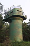 |
The battery is to the South of Ventspils, not far from the Piejūras Park. Work on the battery began in 1939. Today the site is a complete mess, standing out in a negative way from the tidy city itself. People seeking building materials and ferrous metals helped to tear the place down. It’s too bad that this historical location – one that might be of interest to tourists – is in such sad shape, and right at the gates of the city, to boot.
|
|
 |
The Atāli homestead is on Putnu Island, and a local researcher, Ārija Gruberte, has used the threshing barn to exhibit everyday objects used in the area of the ancient Dviete River valley over the course of time. She has collected these items over the course of 20 years, and they include objects dating back to the Stone Age, the Iron age and the Middle Ages. All of them speak to human lives over the course of more than 10,000 years. Please call in advance to arrange for a tour. |
|
 |
Der dritgrößte Feldstein im Baltikum (584 m3, 7 m hoch, Durchmesser bei dem Grund – 32 m ). Auf estnisch bedeutet „Hausstein”. Befindet sich am Rande des Pikanõmme – Majakivi Pfades (4,5 km lang). |
|
 2 days
|
Маршрут проходит по территории природного парка «Излучины Даугавы». Парк создан с целью сохранения уникальных ландшафтов древней долины Даугавы, биологического многообразия и богатейшего культурно-исторического наследия. Наибольшую высоту берега реки достигают в т.н. «Воротах Даугавы», где возвышаются Верверский и Слутишкский обрывы. С Приедайнской смотровой вышки открывается вид на древнюю долины Даугавы с высоты птичьего полета. В 2015 году в Васаргелишках и на горе Лаздукалнс были построены новые смотровые вышки. Информация о маршруте от Latvijas Lauku forums |
|
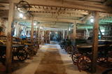 |
The museum is located in Pilkuse manor farm, exhibits on display are carts, carriages and sleighs along with accessories from horse collars to lap robes. Military, emergency and fire brigade carts are extraordinary and rare while a coach and a calash (barouche) are exhibits to be really proud of. Numerous agricultural tools and equipment also ensure hours of excitement and discovery in the museum. |
|
 |
This location is important in terms of Latvia’s history, because during the 12th and 13th century, this was the administrative and spiritual centre of the Lettigalian tribe, with the ruler of Jersika being Visvaldis. The castle stood on the shore of the Daugava at a height of 18 m, and this was a mighty castle hill. The flat part of the hill measured 100 x 75 m, and it was surrounded by a barrier and a defensive wall made of logs. People entered the castle via guarded gates beyond which there were residential and household buildings, as well as a small church. Archaeologists have found the remnants of log buildings, as well as many antiquities from the 10th to the 13th century that speak to extensive trade relations with other parts of Europe, including ancient Russia. In 1209, the forces of Bishop Albert fooled the people in the castle and sacked it and the ancient town that was around it. Visvaldis’ family was taken hostage, and so the Lettigalian ruler was forced to become a vassal of the bishop. The castle hill is privately owned, so please contact the owner before planning a visit. |
|
 |
One of the most distinct sub-glacial depressions in Latvia, with 11 lakes of various sizes and depths. This is a magnificently lovely territory, with particularly good views from the Drusku castle hill. On a clear day, one can even see the Hanja highlands of Estonia. The restricted territory was set up to protect boreal and hillside forests I the area.
|
|
 |
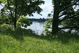
This restricted area protects Lake Jumurda, which is in the central part of the Vidzeme highlands, along with its three islands, the local broadleaf forests, and the surrounding landscapes.
|
|
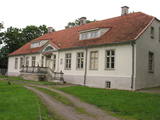 |
Muiža vēsturiskajos dokumentos pirmoreiz ir pieminēta 16. gs. Tagad redzamā vienstāva kungu māja ir vairākreiz pārbūvēta laikā no 17. – 19. gs. 1997. g. ēku vēlreiz atjaunoja un tagad tajā atrodas viesu nams un Vilsandi nacionālā parka apmeklētāju centrs, kur var iegūt ne tikai vērtīgu informāciju, bet arī apskatīt Vilsandi apkārtnē atrastās fosilijas. No Lonas muižas var uzsākt pārgājienu uz Vilsandi salu. Vienā no muižas ēkām ir izveidota Vilsandi nacionālajam parkam veltīta ekspozīcija. |
|
 |
Kemeri (Kemmer) are mentioned in the literature sources for the first time in 1561. In the second half of the 18th century and in the beginning of the 19th century the curative properties of Kemeri sulphur spring waters and swamp mud are well known, therefore here representatives of the highest Kurzeme social circles arrive for treatment. The local foresters welcome the guests. During this time the first mud baths are organised. For some time the development of Jurmala and Kemeri beach is terminated by the Fatherland War of 1812. Two decades later – from 1833 until 1835 the benefits of Kemeri were enjoyed by General Governor of the Baltics Graf K. M. Palen, who addresses the Tsar of Russia Nicholas I for supporting further development of the health resort. Plead is supported and in 1836 Tsar allocates 700 ha of state land and grants 100 000 roubles for the construction of sanatorium and paving of the road from Kemeri till Sloka-Tukums high-way. Two years later (in 1938) the first state bath institution is opened. This is also considered the year of founding the health resort. In several stages the formation of Kemeri Landscape Park is begun, which is an important part of the health resort. In the middle and second half of the 19th century further development of the health resort is promoted by steamboat, as well as railroad traffic that are opened in 1877 from Riga till Tukums. In 1912 direct railroad line Kemeri-Moscow is opened. Early before World War I the number of patients reaches 8300 per year. The 1st battlefront of World War I is held in Kemeri swamp for several years and the health resort is significantly destroyed. Despite this fact after the war it develops rapidly and Kemeri becomes a beloved recreation place for the residents of Riga and one of the most modern health resorts in Europe. In 1924 a new bath institution with mud-baths is built in Kemeri, which at the time is one of the most modern in Europe, but in 1936 State President Kārlis Ulmanis opens one of the most prominent buildings of the first independent state of Latvia period – hotel "Ķemeri". Also after World War II – during the Soviet times the health resort is significantly expanded and almost 10 sanatoriums are established within its territory, in which about 100 doctors are employed. In 1971 Kemeri is awarded the status of All-Union health resort. From 1975 until 1985 the largest of sanatoriums is constructed in Kemeri – Līva (initially – Latvija), which has two blocks of eleven storeys. Up to 1200 patients at the same time could receive treatment at Līva, but within a year – up to 140 000 patients. The sanatorium is closed in the beginning of the 90ies of the 20th century as unprofitable. Up to 1994 five sanatoriums operate in Kemeri: "Čaika", "Daugava", "Dzimtene", "Ķemeri" and "Līva" (Latvija) and resort policlinic "Ķemeri". The latter period may be considered the declining fame period of Kemeri as a large-scale health resort. |
|
 |
The property is located in the picturesque Karula National Park (Karula Rahvuspark). Here you can have a meal and spend the night. The food is mainly prepared from local ingredients in the household kitchen. The farm also breeds bulls. |
|


