
| No | Name | Description |
|---|---|---|
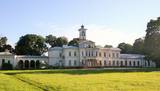 |
This is one of the most expressive estates built in the style of Romanticism. Dating back to the 19th century, it is on a peninsula in Astravo, which can easily be reached from Biržu along the longest wooden bridge in Lithuania, crossing Lake Širvenos. Covering 18 ha, the mixed-plan park was installed from 1851 until 1862. Local fir trees, linden trees and pine trees grow in the park. |
|
 |
Kartavkalnā, kur senāk atradusies seno zemgaļu apmetne, ir izveidota dabas taka ar soliņiem, piknika vietām. Šeit apskatāms arī Jaunpils Kartavu kalns un lapegļu aleja, kā arī iespējams aplūkot, kāda izskatās senlatviešu apmetne ar īstu guļbaļķu sētu.
|
|
 |
One of the leading Latvian sauna experts, Ziedonis Kārkliņš, uses the energetic properties from various plants. More than 12 different plants are combined at once. Natural cosmetics and materials (mud, amber, stones etc.) used during rituals. He also uses ancient Baltic energy signs. |
|
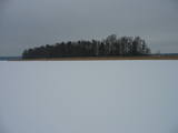 |
There are six islands in the Great Baltezers lake – the Auzu, Priežu, Mazā, Liepu, Ropažu and Meldru islands. These are distinguished by a great diversity of plants, including forests of broadleaf trees, black alders and pines. The territory can be surveyed quite well from the side of the Ādaži Lutheran Church. The Great Baltezers lake is a popular place for fishing, including ice fishing during the winter.
|
|
 1 day
|
Dodieties ekskursijā, lai gūtu ieskatu lauku profesijā un dzīvesveidā, kā arī iegūtu jaunus iespaidus un labu atpūtu visai klasei. Ekskursijas laikā apciemojiet koka skulptūras Vienkoču parkā, kur iespējams iepazīties arī ar koka amatniecību un sameklēt dārgumu lādi. Vai arī apmeklējiet vienīgo vietu Baltijā, kur var iepazīties ar cilvēku dzīves apstākļiem pirms vairāk kā 1000 gadiem. Pēc tam apmeklējiet zemnieku saimniecību, kurā no cidonijām ražo sukādes, marmelādes, sīrupus un citus labumus, un pļavās ganās savvaļas zirgi. Ekskursijas noslēgumā dodieties uz Porcelāna fabriku, lai varētu padarboties apgleznošanas darbnīcā un iepazīties ar ražotni. |
|
 |
The outworker offers different garlic and other vegetable products: marinated garlic flowers, different mixed vegetables; dried garlic rusks, etc. The groups are offered food tasting. |
|
 |
This nature park is located in the most distinct part of the Dagda hillocks of the Latgale highlands. Part of it is the deepest lake in the Baltic States -- Lake Drīdzis, which is 63.1 metres deep and has nine islands. Also there is Lake Otis. The loveliest views can be watched from the ancient Lettigalian castle hill that is known as Sauleskalns, and from the eastern shores of Lake Drīdzis. Accommodations are available near the lake. |
|
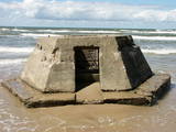 |
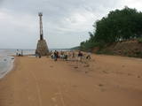
All that’s left of the battery today are the ruins of a cement blockhouse which have slid all the way down to the beach because of years of abuse by the wind and the waves. It is an interesting monument to history with a long-term fate that we can guess at – it will disappear under the sea.
|
|
 |
Vienu kilometru garā lokveida taka, kas ved pa lielāku nacionālā parka meža masīvu, uzskatāmi attēlo Žemaitijas augstienes un tuvākās apkārtnes reljefa veidošanās vēsturi. No takas augstākā punkta – Mikitai kalna, kas ir sens pagānu upurkalns, paveras (ainaviska stiga) tālākas apkārtnes skats. Kā takas interesantākie apskates objekti ir jāmin teikām apvītais akmens ar Velna pēdu un ar akmeņiem izliktas akas paliekas. |
|
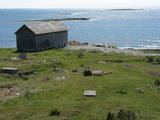 |
No Vilsandi bākas un tai tuvākās apkaimes ir labi saskatāmas leģendārās Vaikas salas. Tām ir piešķirts rezervāta statuss, tādēļ salas var apskatīt tikai no attāluma. Mazākā no saliņām - Kullipank ir tikai pārdesmit metrus diametrā. Tā ir jūras ūdeņu izrobots zemas un asas dolomīta klints fragments, kas klāts ar oļiem, nelieliem laukakmeņiem un kādu atsevišķi stāvošu lakstaugu. Domājams, ka vētru laikā tā pazūd zem jūras ūdens. Savukārt, Alumine Vaigas – Apakšējā Vaikas sala ir lielākā no sešām salām. Šīs salas diametrs ir ~ 150 m un tā paceļas vismaz kādus divus metrus virs jūras līmeņa. Uz salas ir bagātīga veģetācija un pat kāds zems krūms salas centrā. Redzami arī metru augsti atsegumi. Uz salas vēl joprojām atrodas 20. gs. sākumā celto „putnu māju” paliekas, kas bija domātas ligzdojošo putnu piesaistīšanai. |
|
 |
ZS "Jundas" Bauskas novada Vecsaules pagastā saimniecisko darbību uzsāka 2016. gadā. Audzē gaļas šķirņu krustojumu liellopus, tos nobarojot gaļas ražošanai. Strādā atbilstoši bioloģiskas saimniekošanas prasībām. |
|
 |
Ķurmrags is one of the most distinct capes along the Vidzeme shore of the
|
|
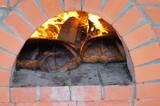 |
The farm uses ancient recipes from grandmothers to bake aromatic sourdough and rye bread on maple leaves, with the crunch crust being processed with flax oil. You can help to bake the bread and then taste and buy it. |
|
 |
You can visit a restored little wooden building to watch and take part in the process of weaving. Natural materials are used to produce lovely souvenirs and useful household products. There are nine looms, and you will hear information about weaving as such. The workshop produces woven scarves which are coloured with natural dyes. |
|
 |
Auf dem Urbo-Hügel befindet sich der 1953 ronovierte schönste Leuchtturm an der Küste Litauens. Das Licht von diesem Leuchtturm kann man in einer Entfernung von 22 Seemeilen sehen. |
|
 |
Saimniecība audzē dažādus dārzeņus, lapu salātus, gurķus, dilles, ķiplokus, brokoļus, ziedkāpostus, sīpolus, ķirbjus, bietes utml. Vasarā un rudenī pieejamas avenes. Pārdošanā svaigi dārzeņi un augļi. |
|
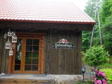 |
The tavern is located in the old log building close to Liepupe Church. There is an old cattle-shed next to the tavern where we make meat and sausage products that you can purchase in the Sudrabņi meat and sausage store. We offer tours and tastings. |
|
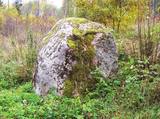 |
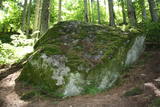
The Devil Stone of Ubagova (Čorta kameņs). The cult place is situated in the Southern side of the
village Ubagova 30m to the N NW from the cemetery of the village. According to the legend, there are
ghosts so you shouldn’t walk there alone because they can trap you in the woods. The boulder is about 1.6
m high. The surface is smooth, without any cuts.
|
|
|
|
Der Turm befindet sich im Gutspark Kiiu. Wurde im ersten Viertel des 16. Jh. errichtet und diente als einen „Schutzraum” für Grundbesitzer. Geöffnet für Besucher und bietet den berühmten estnischen Likör „Kiiu torn” an. |
|
 2 days
|
This route offers most unusual views. Seda is the only town in Latvia with Soviet-era planning from the middle of the last century, featuring a central square and streets stretching from it in a star pattern. The architectural style of apartment and public buildings is rather exotic. The Seda Swamp yielded peat moss during the first period of Latvia’s independence and is one of the largest industrial and environmental territories of its kind in Latvia and the Baltic States. Former peat fields have partly become flooded and are overgrown with reeds, thus creating an outstanding environment for nesting water birds and migrating birds which rest at the swamp. Peat is still being extracted, and perhaps you will be lucky enough to spot the “little peat moss train.” Route information from Latvijas Lauku forums |
|


