
| No | Name | Description |
|---|---|---|
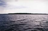 |
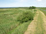
This is Latvia’s oldest nature reserve and, indeed, the country’s oldest protected natural territory. Moricsala is an island in Lake Usma, which is the fifth largest lake in Latvia. The reserve was established in 1912 at the initiative of a group of nature students from Rīga. They wished to protect the deciduous forest of oak trees on the island, along with the local flora and fauna. The nature reserve also includes the Lielalksnīte island. Visits to the reserve, however, are strictly prohibited. |
|
 |
The theme park of wise men of Gotham (Kilpla) is located in Müüsleri village; the park’s attractions arise from legends told in Germany some 400 years ago. Gothamites are funny characters famous for their irrational, impractical and foolish actions. Fun-packed tours and activities are on offer along with craft workshops, themed souvenirs, catering (groups should book in advance), and grounds for pitching tents. |
|
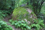 |
200 m attālumā no Gulbenes – Madonas ceļa mežainā nogāzē iegūlis 2,4 m augstais akmens. Tā lēzenajā virsmā iekalta ap metru gara, 0,3 m plata un ap 4 cm dziļa iedobe, bet akmens šķautnē - pakāpieni. Uzskata, ka šis ir sens kultakmens, pie kura ziedots. Lai nokļūtu līdz akmenim, vasaras otrajā pusē var nākties brist pa garu zāli. |
|
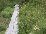 |
Teritorijas apskates nolūkos ir izveidota un labiekārtota dabas izziņas taka. Dabas liegums atrodas Abavas senlejas dabas parka teritorijā. Taka iepazīstina ar vienīgo krūmu čužas savvaļas augšanas vietu Latvijā. |
|
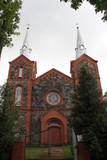 |
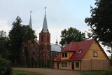
Dievnams celts no šķeltajiem laukakmeņiem un sarkanajiem ķieģeļiem laikā no 1894. - 1909. g. Tajā saglabājušās vecās koka baznīcas iekārtas un 18. gs. sākumā veidots cilnis “Svētais vakarēdiens”. |
|
 2 days
|
Маршрут проходит по территории природного парка «Излучины Даугавы». Парк создан с целью сохранения уникальных ландшафтов древней долины Даугавы, биологического многообразия и богатейшего культурно-исторического наследия. Наибольшую высоту берега реки достигают в т.н. «Воротах Даугавы», где возвышаются Верверский и Слутишкский обрывы. С Приедайнской смотровой вышки открывается вид на древнюю долины Даугавы с высоты птичьего полета. В 2015 году в Васаргелишках и на горе Лаздукалнс были построены новые смотровые вышки. Информация о маршруте от Latvijas Lauku forums |
|
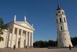 |
The Capital of Lithuania. One of the biggest East Europe's old towns (included in UNESCO World's Cultural Heritage list) where there is a lot of representation of various architecture styles like Classicism, Baroque, Gothique, etc. |
|
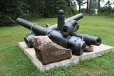 |
Dole Island is the largest river island in Latvia, and it is the site of the Dole baronial estate. The mansion of the estate was built in 1898 by the aristocratic family which owned the estate. Today the mansion is home to the Dole Museum with a rich exhibition which tells about the lives of people on the shores of the Daugava River. The adjoining park features ethnographic buildings, as well as lamprey and salmon spawning grounds. There are five unique cannons that were found in Salaspils when a new stadium was being built there. In 1910, a tsarist military camp was here, and a monument to Tsar Peter the Great was unveiled. One of the cannons is in the exhibition of the museum itself.
|
|
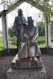 |
The monument is next to the Vecpiebalga Cultural Centre. Its architect was Ausma Skujiņa, and the sculptress was Maija Eņģele. |
|
 |
Находится~ в 4 км, не доезжая до Априки (установлен указатель) – Гибортское кладбище. Слепой Индрикис (1783 – 1828) был латышом, опубликовавшим первое собрание стихов на латышском языке (1806 г.). Индрикис был слепым с 5-летнего возраста и был необразован. Его стихи записал и издал в упомянутом году священник Априкского прихода K. Г. Элверфелдс. На кладбище установлен памятный камень (1935 г.) и созданное Вилнисом Титансом «Аустрас кокс» с надписью шрифтом Брайля. |
|
 16 days
|
This long-distance tour follows the Baltic Coastal Hiking Route from the Lithuanian coast, starting on the island of Rusnė and continuing to the Curonian Spit, running along the Baltic Sea coast to Cape Kolka and finally reaching Rīga. On this route you will hike some sections of the Baltic Coastal Hiking Route and experience the diversity of coastal landscapes: rocky beaches, steep shores, overgrown beaches, bird migration sites, vast sandy beaches. You will walk on solitary beaches with no-one in sight for several kilometres just to suddenly find yourself in lively resort towns. There are both sections of hiking and bus transfers along the route. Initially you will visit the peculiar island of Rusnė with its bird migration sites, observation towers and the delta Crossing the Lithuanian/Latvian border on foot you will stop over at the Pape Nature Park and enjoy its lighthouse, wild horses, the authentic fishermen village and local museum. The walk on lone beaches takes you to the top of the highest dune in Latvia – the Pūsēnu dune – and afterwards continues to reach the village of Bernāti. Next on the route is the windy seaside city of Liepāja, also known as the Latvian capital of rock music. Karosta is another distinctive site in Liepāja – it is the former military town and nearly every street of this part of the city has some footprints of its military heritage. Heading further, your feet will take you through the solitary beaches of Ziemupe to the village of Pāvilosta. If you are lucky, you might find some ambers washed ashore. Pāvilosta is a small charming village with a marina and some notes of smoked fish lingering in the air. Moving on, from Ventspils through Slītere National Park, through the Livonian fishermen villages to finally reach the Kolka Cape – the meeting point of the Baltic Sea and the Gulf of Riga. Also, a top site for bird watching. At the end of the tour, the Baltic Coastal Hiking Route leads to Engure Nature Park, meandering through reed trails running between the villages of Mērsrags and Engure. The tour ends in Jūrmala with its wide sandy Beaches, the bustling urban life of a resort town, impressive villas and summer cottages, and the Ragakāpa Nature Park in the resort’s neighborhood Lielupe. |
|
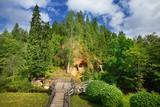 |
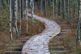
Klinšu smilšakmens ieži veidojušies, ūdens straumēm sanesot smilšainas, mālainas iežu daļiņas. Tās lēnām nogulsnējās un sablīvējās, topot par vareniem dabas veidojumiem! Līgatnes pagrabu alas savām rokām radījuši senie iedzīvotāji. Šī neparastā vieta ļāvusi daudzām paaudzēm izdzīvot, jo alās bija iespēja uzglabāt nepieciešamās pārtikas rezerves. Alām ir nemainīga temperatūra, kas padara tās par drošu pārtikas produktu un dzērienu glabātuvi. |
|
 |
Saimniecība "Baltiņi" atrodas Auces novadā un nodarbojas ar lopkopību un lauksaimniecību. Viesiem ir iespēja redzēt un izzināt piena ražošanas procesu, kā arī iepazīt saimniecības dzīvniekus. Saimnieki piedāvā apskatīt padomju laiku auto kolekciju, pieejama arī suvenīru un trauku kolekcija ar govs motīviem. |
|
 |
The Nemuna River divides up into two large streams at its estuary at Kuršių Marios, and this has established the Rusnė Island. This is a unique environmental territory with wetlands, streams, ancient rivers, lagoon lakes and flood plains which are important places for birds to nest and rest during migration season. Vast tracts of this territory are flooded each spring. The park includes the territory to the N and W of Rusne (lagoons, swamps, fishing ponds, Kuršių Marios).
|
|
 | ||
 |
0,2 km austrumos no Vidsmuižas atrodas no šķeltajiem laukakmeņiem un sarkanajiem ķieģeļiem celtā (1910. - 1912. g.) Vidsmuižas katoļu baznīca. Tāpat kā Riebiņos esošā, arī šī ir uzskatāma par tipisku 19. – 20. gs. mijas Latgales lauku baznīcas paraugu. |
|
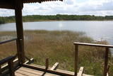 |
This is on the north-western shore of Lake Lielezers of Limbaži, at the start of the Lielezers nature trail. The tower opens up a view of the lake and its lovely shores. It is worth walking the trail, which is several kilometres long, because it is an interesting one. This is part of the ZBR. |
|
 |
This is the ancient shore of the Baltic Ice Lake. We can only imagine the landscape 10,000 years ago, when the Kurzeme peninsula was covered with vegetation reminiscent of a tundra, and waves from the icy lake dashed against the ancient shoreline. We know that the lake was full of icebergs of various sizes. Today the cliff is more than 20 km long (some 9 km of it are in the Slītere National Park), and it is as much as 42 m high. It is the most impressive cliff of its type in all of Latvia. At the foot of the cliff are the Irve flatlands (the name comes from the Liv 'īrva' or 'īra', both of which refer to deer). The flatlands are the former bottom of the Baltic Ice Lake. The Blue Hills are crossed by many small streams and rivers (Pitragupe, Lorumupe, Kaļķupe, Mazupe, etc.). Their valleys are the basis for a branched and very complicated system of waterways which look particularly impressive when the trees are bare. In many places the cliffs and valleys display small areas of sandstone from the Narva suite. These are Latvia's oldest sediment cliffs that can be seen above ground. Although the Blue Hills are very impressive in scope, there are only a few places where there are important viewing areas (a viewing tower at the Dundaga-Mazirbe road, the view from the Šlītere lighthouse, the view from Mežlīdumi). The mightiness of the ancient shoreline can truly be enjoyed from the Cirste-Mazirbe road, the Cirste-Riepaldi road, Mežlīdumi and the Vīdala-Melnsils road). It is worth visiting the area in the springtime, when the slopes of the Blue Hills seem to be sinking under the fresh greenery. |
|
 |
Der Turm befindet sich im Gutspark Kiiu. Wurde im ersten Viertel des 16. Jh. errichtet und diente als einen „Schutzraum” für Grundbesitzer. Geöffnet für Besucher und bietet den berühmten estnischen Likör „Kiiu torn” an. |
|
 |
Reinis Kaudzīte, co-author of the first Latvian novel “Times of the Land-Surveyors” (“Mērnieku laiki”) stayed in Pēterupe Village from 1913. |
|


