
| No | Name | Description |
|---|---|---|
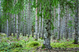 |
Kaziņmežs is a small area of forest to the East of the Cirste-Mazirbe road where
it intersects with the Kolka-Ventspils road. This is a fabled place. When we take the
Krustceļš route through Kaziņmežs, we arrive at the Kolka-Ventspils road (P 124).
|
|
 |
Lovely café, located in the old folk house; here you can buy unique cheeses, dumplings, chanterelle-bean-pear barley soup, vadsas, meadow-sweet syrup drink. |
|
 3 days
|
This tour will take you exploring the peculiar island of Rusnė and the delta of the river Nemunas in Lithuania. The island of Rusnė in the Nemunas Delta Regional Park is enclosed by waters of the river Nemunas and its tributaries. It is a resting place for migratory birds and home to a cormorant colony. The area of the island is 45 km2 and it is connected to the mainland by a bridge. The island of Rusnė is the lowest place in Lithuania, lying below sea level. The historic centre of the town Rusnė is characteristic of authentic wooden architecture, buildings painted in bright colours, colourful window shutters and decorations. The Baltic Coastal Hiking Route leads through the small town of Šilutė, revealing architecture that was once common to East Prussia. From Šilutė to Kintai, the Baltic Coastal Hiking Route runs along a low plain. To protect this area from flood waters of Nemunas, there is a system of dams, polders and canals established. After crossing the river Minija, the route invites you to visit the ethnographic village of Minija. Here you can enjoy the lowland landscape of the seaside region with vast wetlands and ponds. |
|
 |
Rabbit farm offering rabbit meat, skin and its products. The key to success is high-quality food, veterinary care and good rabbit-keeping conditions. |
|
 |
Windmill restaurant Saaremaa is the most popular restaurant amongst locals, offering the best and freshest products. The menu includes game meat from Saaremaa forests, smoked fish during summer, treats from berries, local apple wine, as well as the best wines of Saaremaa Island. |
|
 |
Located on the shores of Lake Usma, it provides diverse water- and land-based recreational opportunities, a free picnic area and outdoor fireplace, as well as catering services. |
|
 |
Atrodas Taurenē, Gaujas labajā krastā. Muižas apbūve, kurā ietilpst pils (19. gs. 80. gadi, arhitekts – R. G. Šmēlings, historisma un neoklasicisma stils), senie alus pagrabi, klēts, vecā pils un parks, veidojies 19. - 20. gs. Šobrīd muižas pilī atrodas Taurenes pagasta pārvalde un kultūras nams. Muižas kompleksā ietilpst ēka, kurā atrodas Vecpiebalgas novada tūrisma informācijas punkts un Taurenes novadpētniecības ekspozīcija (senajā ledus pagrabā). Parkā (ziemeļos no pils) uzmeklējams piemiņas akmens, kas veltīts komunistiskā terora upuriem. Pie Nēķena muižas sākās 0,4 km garā Cieres dabas taka, kas iepazīstina ar Gaujas krastu mitrājiem. |
|
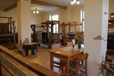 |
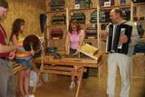
Found in the Alsunga Museum, this workshop demonstrates how the folk costumes and accessories of the Suiti community are produced. Visitors can learn about weaving traditions in the area and examine the colourful range of folk costumes. Visitors are welcome to try their hand at the work under the guidance of experienced specialists. |
|
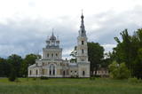 |
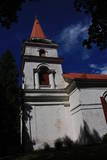
The owner of the Stāmeriena Estate was Baron Johann Gottlieb von Wolff, and his wife, Sofia Potyomkina, was a member of the Russian Orthodox faith, so work on the church began in 1902. It was consecrated two years later. The crosses on the steeple of the church are known for mountain crystals that were presented by the Wolff dynasty. Contact the church in advance for a tour of its interior. |
|
 |
Here you will find a vast collection of antique instruments. You’ll learn about their history and about how they were manufactured. You can play music or commission or purchase homemade instruments. If you contact the venue in advance, the Igaunis family will organise a concert performance for you. |
|
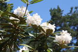 |
72 types of wild rhododendrons with 193 different species
This is the only specialised rhododendron nursery in the Baltic States. Specialists there work on different kinds of rhododendrons, seeking to produce decorative and winter-resistant types of the flower. The nursery also sells plants. In the facility’s pine forest, which covers 11.8 hectares, you can see a large collection of rhododendrons from all over the world.
There are 64 winter-resistant types of rhododendrons at “Babīte,” including “Alma Mater,” “Academia Scientiarum,” “Emeritus,” “Eduards Smiļģis,” “Dita Krenberga,” and others (these were developed by Rihards Kondratovičs). All of these are appropriate for Northern Europe.
|
|
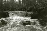 |
Here we find a set of canyon-type gullies among layers of dolomite. There are impressive outcrops and small waterfalls in the little river’s bed.
|
|
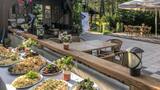 |
The “Banquet With Fishermen” event in Roja allows guests to examine the work of fishermen and to enjoy the seafood which they produce. Guests will ride out into the sea in fishing boats and then dine together with the fishermen (fish soup cooked on a campfire, rye bread, butter, smoked fish, beer or kvass, and pastries). The fishermen will teach guests local songs and dances, as well as games related to strength and cleverness. The “Otra Puse” restaurant offers meals. Latvian cuisine: Fresh fish (“The Morning Catch”), Latvian onion soup, porridge, grit sausage, smoked fish, potato pancakes, rye bread dessert, beer, the “Dzimtenīte” beverage, herbal tea, birch juice, apple cider. Special foods: “Made in Roja” – fish from the region, “mackerel in in grass,” “cottage cheese tower with fresh strawberry sauce”. |
|
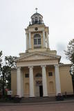 |
Lai arī dievnama pirmsākumi meklējami 18. gs. sākumā, tā celtniecību (arhitekts Johanns Eduards de Vite) pabeidza viena gada laikā 1834. – 1835. g. (vēlīnā klasicisma stils). Būvniecības darbus finansēja Krievijas cars. Gan baznīcas atrašanās piejūrā, gan arī tās nosaukums liecina, ka tā celta, godinot Svēto Nikolaju, kas ir visu jūrnieku un zvejnieku aizbildnis. Baznīca apskatāma arī no iekšpuses, kur uzmanība jāpievērš ērģelēm un altārgleznai (1888. g.). |
|
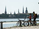 |
The Capital of Latvia. The Old Town of Riga (included in UNESCO Cultural Heritage list) - an excellent medieval building monument. The pearl of Art Noveau in Europe. The former city of Hanza. |
|
|
|
Established in 1992, the Mežacīruļi farm is in the Zaļenieki Parish of the Jelgava Administrative District, alongside the basin of the Lielupe River. The farm initially had 7.2 ha of land, 3 cows, 20 head of sheep and 6 sows. Today it has 700 ha of land, 300 dairy cows, and a series of hothouses to grow lettuce and herbs. |
|
 |
When you travel along the northern shore of Lake Sauka where the road to Klauce crosses your road, you will see the Sauka Lutheran Church among the trees. This is the third church at this location. It was opened in 1827 and can mostly be viewed from the outside. The altar is decorated with sculptures of St Peter and St Paul, as well as the altar painting “Jesus on the Cross with Mary and John,” which is by J. Doering. The organ was built by craftsmen in Jelgava, and the pipes were manufactured in Sauka. |
|
 |
Saimnieki piedāvā vietu, kur aizbraukt brīvā laika pavadīšanai, atpūtā ģimenei Kurzemē. Šeit viesiem ir iespēja aplūkot sākot no dažādu laiku lauksaimniecības tehnikas un darbarīkiem, līdz pat kara laika paliekām, kā arī dažādu laiku sadzīviskos priekšmetus. Katram priekšmetam seko arī stāsti, kas ir piedzīvoti vai tikai dzirdēti. Tāpat apmeklētājiem ir iespēja apskatīt mājas iemītniekus,kas ir veidoti ar pašu rokām. Asākām un patīkamākām sajūtām pieejama 350 metrus gara Baskāju taka. |
|
 |
The Pīlādži farm is in the Durbe Parish of the Durbe Administrative District. It is primarily a grain farm, but also breeds livestock and grows flowers and vegetables. |
|
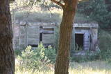 |
The 77th Zenith Missile Brigade of the Soviet Army was charged with air defences along the Soviet Union’s external border. The facility is owned by the regional local government and is not used for anything. There is an interesting gate at the entrance to the facility, however.
|
|


