
| No | Name | Description |
|---|---|---|
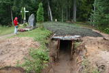 |
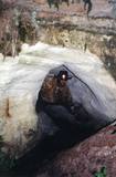
In October 1948, nationalist partisans who opposed the Soviet regime built a 9x6 m bunker in the forests of Īle for themselves. Five months later, the KGB attacked the bunker. After five hours of gunfire, 15 partisans lay dead, and another nine were captured. The bunker has been restored in commemoration of this event, and it is open to visitors.
|
|
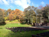 |
features an open-air stage in a lovely place. During the summer there are concerts, theatrical performances, parties, Summer Solstice celebrations, etc. The International Bourdon Festival is held once every four years, and the next one will be in 2020. This brings together bourdon singers from many countries in the world. |
|
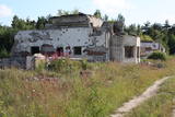 |
There are several partly preserved buildings here, but there is a lack of information as to what they were used for. The reason why the buildings are in such sad shape is that people have removed parts of them to use as building materials.
|
|
 |
Although out of 104 village houses 97 were destroyed during World War I, at the end of the 30ies of the 20th century Lapmezciems "recovered" fast, and one of the most powerful coastal fishermen cooperatives in Latvia were operating in it. During the Soviet times here one of the largest fishery collective farms – "Selga" was founded here, the blocks of which can be seen at the mouth of the Siliņupe River. Today Lapmezciems is a popular area for summer cottages, a recreation and bathing place. As an interesting history monument of fishery the sedum of Lapmezciems is available for viewing – it is the former wharf of fishing boats, where fishermen built nest cabins and stored their equipment. Between Pīlādži Street and the left bank of the Siliņupe River in the 3rd and 2nd millennium BC settlement of fishermen and hunters were located, where a memorial stone is erected. This is the most ancient known location populated by humans within the territory of Kemeri National Park. Part of the findings is displayed at Lapmezciems museum, where local history research exposition is formed and materials about Finnish Jeager fights within the territory of Klapkalnciems are gathered. |
|
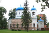 |
Atrodas pilsētas centrā, Atbrīvošanas alejā 98. Dievnamu sāka celt 1840. g. (iesvētīja 1846. g.) un tas uzskatāms par pilsētas vecāko sakrālo būvi. Nekvalitatīvu būvniecības materiālu izmantošana un cēlāju pieredzes trūkums bija iemesls, kādēļ 1854. g. to nācās pārbūvēt. Pie baznīcas atrodas 1867. g. būvēta Sv. A. Ņevska kapliča, kas veltīta cara Aleksandra II paglābšanās faktam vilciena katastrofā un stikla mauzolejs, kurā apbedīts baznīcas mecenāts ģenerālis Karaulovs (šobrīd tiek restaurēts). Dievnams ir atvērts arī apmeklētājiem. |
|
 |
Arī 18. novembra laukums. Tas sācis veidoties 18. gadsimtā kā tirgus laukums. Tā dominantes bija 1752. g. celtais rātsnams (nav saglabājies) un aptieka, kas šajā ēkā darbojas no 1810. g. līdz pat mūsdienām. 2010. gadā laukumā izveidota strūklaka, kam ir pilsētas ģerboņa forma. |
|
 |
The Smārde saloon has a very long history,
and food is served here. There is a car park, and
approx. 100 m to the East is a cemetery and
monument to commemorate soldiers who fell
during World War II.
|
|
 |
Elkas kalna saimniecība is located on the top of the scenic Elkas Hill, the place where the Gauja begins. Herbal teas, birch sap, jams and other healthy delicacies from local meadows and home-grown plants. There are also nature workshops, open-air picnic areas. |
|
 |
Atrodas 0,1 km ziemeļos no Dobeles pilsdrupām - laukumā starp Tērvetes ielu un Liepājas šoseju. Tas veltīts 1. pasaules karā un Latvijas Brīvības cīņās kritušajiem kareivjiem. 1940. g. pilsētas Vienības laukumā atklāto pieminekli (tēlnieks K. Zemdega) desmit gadus vēlāk uzspridzināja, bet 1996. g. atklāja no jauna (tēlniece I. Berga). Laukumā apskatāms 1989. g. uzstādītais piemiņas akmens (tēlnieks M. Zaurs) zemgaļu aiziešanai no Dobeles, kas notika 1289. g. Pirms aiziešanas uz Lietuvu, tie nodedzināja savu koka pili Dobeles pilskalnā. No laukuma paveras labs foto – rakurss uz Dobeles pilsdrupām. |
|
 2 days
|
This part of the Forest Trail passes through the historical centre of Valmiera. In Valmiera you can visit St. Simon’s Church, the Ruins of the Livonian Order Castle and Valmiera Museum. We also suggest walking the barefoot trail in “Sajūtu Parks” (Park of Senses). After sightseeing in Valmiera, the Forest Trail goes through Atpūtas (Recreation) park, the beautiful pine forest and Baiļi winter ski centre. Further on you will walk along the River Abuls Trail, curving along the banks of the river until reaching the Brenguļi brewery built in an old Hydroelectric power plant. You can enjoy unfiltered and unpasteurised beer here. Further down you will enter unpopulated forest areas and the Northern Gauja protected landscape area. The forests in Northern Gauja (“Ziemeļgauja”) are very diverse. There are old or natural boreal (northern) forests and marsh forests, oak forests, alluvial forests (formed on river sediments which periodically flood) and mixed oak, wych elm and ash forests along the river. The tour will end in Strenči Town. |
|
 |
Regīna Kalniņa is one of the best known craftswomen in Kurzeme. She weaves blankets and shawls and knits colourful mittens. She also sews Rucava and Nīca folk costumes. The process of weaving and knitting can be viewed. Regīna’s products are widely demanded in Latvia and in other European countries. |
|
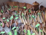 |
The spoon workshop offers useful objects such as wooden spoons, cutting boards, butter knives, pans, spatulas, etc. You can produce your own wooden spoon and look at finished spoons made of more than 17 different types of wood from Latvia. During the summer the owners offer “pancake tours” with tasty jams. You can purchase spoons and homemade wine. |
|
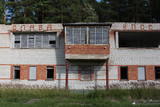 |
The firing range at Skujnieki was once used for summer sports, as well as training in the use of firearms. The Defence Ministry still uses the facility from time to time. The central building of the facility was built in 1982, and its façade is decorated with text in the Russian language: “Слава КПСС” (“All Honour to the Soviet Communist Party).
|
|
 |
Vairāki dažus metrus augsti smilšakmens atsegumi, kas izveidojušies Stiglavas (Stiglovas) strauta gravas nogāzēs. Kaut arī teritorija tiek popularizēta kā tūrisma objekts, tajā nav īpašu šim nolūkam paredzētu labiekārtojumu. Teritorijas apmeklētāji bojā smilšakmens atsegumus, kas ir aizsargājami biotopi!
|
|
|
|
Atrodas Cenas tīreļa dabas takas sākumā. No tā labi pārskatāma kūdrā izstrādātā Cenas tīreļa neliela daļa. |
|
 |
This museum is along the road from Jaunpiebalga and Vecpiebalga and was opened in 1969. It focuses on the life and work of two distinguished Latvians – the composer Emīls Dārziņš (1875-1910) and the poet and writer Jānis Sudrabkalns (1894-1975). It features items related to the lives of the two men. Music by Dārziņš can be heard in the museum, tours are offered to individual visitors and groups, and thematic and musical events are held at the museum. |
|
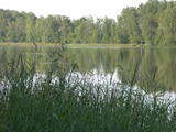 |
These two lakes, along with Lake Mazezers, Lake Auziņš, Lake Skuja and Lake Bruņķītis, are found in a sub-glacial depression with shores and hillsides that are home to various kinds of forest, including stands of broadband trees such as ash. These are protected habitats. Alongside the Priedītes homestead there is a well-appointed nature trail for visitors who wish to study Lake Dziļezers and its surroundings. A boating facility is on the north-eastern shore of the Lake.
|
|
 |
Cecīļu dabas taka ir kājāmgājēju tūrisma maršruts, kurā ir iespēja iepazīt Amatas novada dabas objektus gar Kumadas upes, Dančupītes un Amatas upes krastu. Takas sākuma punkts ir Amatas novada Ieriķos, 1 km no kafejnīcas, degvielas uzpildes stacijas, Cecīļu dabas takas apmeklētāju centra, blakus autoservisam. Apmeklētājiem ir iespēja izbaudīt cilvēka nepārveidotu dabas ainavu – Dančupītes kanjonu, minatūru ūdenskritumu, no Kumadas upes labā krasta aplūkot iespaidīgo Cecīļu iezi un citus objektus. Taka ir marķēta. |
|
 |
Akmensrags is important for birds while they are migrating, spending the winter, and molting in the summer. Most often we find the little gull and the red-throated and black-throated loon. The territory is opposite the Pāvilosta Administrative District and covers 25,878 hectares.
|
|
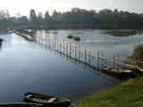 |
This is one of the few places in the world where lamprey eels are caught at the industrial level and with a fishing method that has been used for the past 150 years – a weir that stretches across the river and has creels along it. There are three weirs in all on the Salaca River. A local fisherman will teach you about the process and allow you to taste and purchase roast lampreys. |
|


