
| No | Name | Description |
|---|---|---|
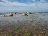 |
This is an important territory for the protection of reefs. It is opposite the Salacgrīva Administrative District and covers 3,577 hectares. The marine part of the “Rocky Shore of Vidzeme” nature reserve is a part of the territory.
|
|
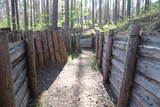 |
Ar Kara muzeja informatīvo atbalstu Garā kāpā pie Antiņiem ir rekonstruēta daļa latviešu strēlnieku nocietinājumu sistēmas. Aspkatāmas ierakumu pozīcijas un vairākas zemnīcas. Netālu atrodas bijusī un no dzelzsbetona veidotā medikamentu glabātuve. |
|
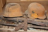 |
In 1944, between November 14 and December 9, there were fierce battles between SD and SS units from the German 16th Army, under the command of Police General Friedrich Jekeln, and a separate battalion of the Kurelians, under the command of Lt Roberts Rubenis. The battles were waged in the Ugāle, Usma, Renda and Zlēki parishes. Rubenis’ men were well-armed and organised. There were more than 600 troops, and the soldiers saw themselves as a national force which stood apart from the two hostile occupant regimes. This was the longest and most extensive battle in the history of Latvian national resistance. As the military force of the Latvian Central Council, the unit enjoyed extensive public support and confirmed a high level of morality in fighting for the restoration of a democratic Latvia. (The preceding text comes from the Rubenis Fund.)
|
|
 |
Das im 18. – 19. Jh entstandene Ensemble von Gutshofsgebäuden mit Museum Audru und Spiritusfabrik. |
|
 |
This park was set up to protect the landscape and cultural environment of the Haanja highland. At the central part of the park are the two highest hills in the Baltic States – Suur Munamägi, which stands 318 m above sea level, and Vällamägi, which is 304 m above sea level. The ancient Rõuge River valley (Rõuge ürgorg) is found in the western part of the park. It is 7.5 km long and up to 60 m deep. The valley dates back to the Ice Age, and it has seven lakes, including the deepest one (38 m) in Estonia – Lake Rõuge Suurjärv.
|
|
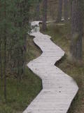 |
One of the most attractive and informative nature trails in the environs of Rīga. It leads the visitor around the 17-metre Ragakāpa dune, which is most interesting. People can learn about the habitats of the dune areas and the plants and animals of the area. Some of the pine trees are as much as 100 years old and more. The trail is 2km long in each direction and will take some two hours to traverse. This is part of the Ragakāpa nature park.
|
|
 |
In the small town of Pļaviņas, at the place where the Skanstupīte River flows into the Daugava (Friendship Park), there are the remnants of a set of small and low fortifications known as the Swedish bastions. This was a place of military and political importance, because here was the place where the boundaries of Vidzeme (under Swedish rule), Latgale (under Polish rule), and the Duchy of Kurzeme (on the opposite side of the river) all came together. In 1625, the Swedes were defeated by the Poles here, and Swedish King Gustav Adolf almost lost his life. Medieval bastions of this kind can be seen in some other places of Latvia, as well.
|
|
 |
The Slītere National Park (established in 2000) is known, with good reason, as an open-air museum which shows the historical development of the Baltic Sea. Nowadays evidence of geological events is seen in the Blue Hills of Slītere, which stand 20 to 30 metres high above what was the shore of the Baltic lake of ice 10,000 years ago. The Stiebri hills were former 8,000 or 9,000 years ago, while the Littorina Sea formed Europe’s largest set of dune ramparts and damp hollows between those ramparts. This occurred between 4,000 and 7,000 years ago. The gentle climate of Northern Kurzeme is the reason why so many rare plants are found in the park – some 860 in all including Common Yew (Taxus baccata) and Baltic Ivy (Hedera helix var. baltica). Of certain value in the preservation of these treasures was the Soviet military machine, which has left behind army bases and other military objects in the area. The presence of the military meant that the area of what is now the Slītere National Park remained largely undisturbed for 50 years. The park includes one of the most popular tourist destinations in Latvia – the Cape of Kolka, which is visited by more than 50,000 travellers each year. During the spring migration of birds, more than 60,000 birds cross the cape each hour. Along the shore of the Baltic Sea is the so-called Livonian coast, which stretches from Kolka to Sīkrags and Ovīši. Fishing villages and other cultural objects established by the world’s smallest ethnic minority, the Livonians, can be found here. Tourists will enjoy interesting four nature trails, bicycling routes, viewing tower, etc. The visitors centre is located at the Slītere lighthouse. Administration of National park is organising environmental education events on regular basis open to everyone. |
|
|
|
The craftsmen's association unites 65 craftsmen from Rūjiena and its surroundings. Offers baking, jam cooking, cheese tying, jewelry making, leather goods, crochet and culinary master classes. Also offers "Made in Rūjiena" tastings (bread, smoked products, culinary products, jams, fresh juices, pumpkin products, seasonal berries and fruits, other dishes in each season) and shopping. |
|
 |
The eastern, southern and western shores of Lake Rāzna have roads which offer many lovely and unusual views of Latvia’s second largest lake and its surrounding landscape. Particularly lovely is the road between Foļvarkova and Vilkakrogs, which is part of the Rēzekne-Ezernieki road.
|
|
|
|
Auf einer hohen vom Wald bedeckten Düne, wo sich in 14 – 15 Jh. ein heidnisches Heiligtum und eine Sternwarte befand, wurde 1869 eine Kapelle und Skulptur erbaut. Eine Geschichte über Priesterin Birute, die das Großfürsten Kestutis geheiratet und den Sohn Vitautas geboren hat. |
|
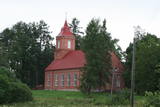 |
Līdz 18. gs. šajā vietā bija koka baznīca, kamēr 1798. g. uzcēla mūra baznīcu, kas cieta 1. pasaules karā, bet 2. pasaules kara laikā to uzspridzināja. Tikai pusgadsimtu vēlāk - 1991. gadā tika uzsākti atjaunošanas darbi, kas joprojām turpinās. Tagad redzamais dievnams ir iepriekšējā līdzinieks. |
|
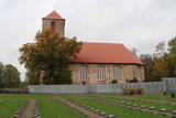 |
The graveyard that is alongside the Lestene Lutheran Church is the final resting place for more than 900 soldiers who fell during World War II, particularly during battles at the so-called Fortress of Kurzeme, as well as in Zemgale and Vidzeme. The sculptress Arta Dumpe designed the commemorative monument “Mother Motherland – Latvia.” The cemetery of the brethren is the second largest resting place for soldiers from World War II after the Cemetery of the Brethren in Rīga. The names of some 11,000 soldiers are engraved on the gravestones. |
|
 |
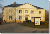
The centre was opened in 2018 with the aim of facilitating tourism in Alsunga and the historical Suiti territory and to offer information about the district, thus establishing a positive and attractive image for Alsunga and the historical territory in Latvia and abroad. |
|
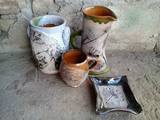 |
The ceramicist works in the household building of the Durbe Castle. You can watch her at work, try your hand at ceramics work, order artworks and purchase clay souvenirs. You can also tour the Durbe Castle complex, which is undergoing renovations at this time (2013). |
|
 |
Although out of 104 village houses 97 were destroyed during World War I, at the end of the 30ies of the 20th century Lapmezciems "recovered" fast, and one of the most powerful coastal fishermen cooperatives in Latvia were operating in it. During the Soviet times here one of the largest fishery collective farms – "Selga" was founded here, the blocks of which can be seen at the mouth of the Siliņupe River. Today Lapmezciems is a popular area for summer cottages, a recreation and bathing place. As an interesting history monument of fishery the sedum of Lapmezciems is available for viewing – it is the former wharf of fishing boats, where fishermen built nest cabins and stored their equipment. Between Pīlādži Street and the left bank of the Siliņupe River in the 3rd and 2nd millennium BC settlement of fishermen and hunters were located, where a memorial stone is erected. This is the most ancient known location populated by humans within the territory of Kemeri National Park. Part of the findings is displayed at Lapmezciems museum, where local history research exposition is formed and materials about Finnish Jeager fights within the territory of Klapkalnciems are gathered. |
|
 |
This is the highest church tower in Latvia, and from it you can see views of the Alūksne highlands. The view to the South is particularly impressive.
|
|
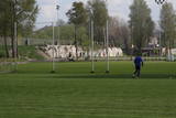 |
A small part of the impressive fortifications of Liepāja, these encircle the city’s perimeter and its shoreline. They’re found at the Olimpija stadium. See also Objects No. 30077, 30078, 30079, 30080 and 30098.
|
|
 7 days
|
The most spectacular autumn events are the Crane shows which can be observed at the bogs and fields. The tour will pass several of these places. We have included different biotops in the tour- seacost, different forests, bogs and fish ponds- in order to see various bird species. |
|
 |
Farm Maizes māja near Cēsis, where you can gain joy, strength and vitality! This tourism farm offers cognitive and educational programmes for adults and children, introducing them to the traditional Latvian lifestyle and intangible cultural heritage. At Maizes Māja, groups of students, families, friends, and tourists become members of the family and have a lot of work to do, for example, bringing firewood and firing the oven, before baking rye bread or sweet and sour bread from Kaupo rye flour in a proper bread oven. When the work is done, a nice meal is enjoyed together. |
|


