
| No | Name | Description |
|---|---|---|
 |
Mulgi Kõrts (tavern) in Abja-Paluoja, the centre of Mulgi area, has a cosy atmosphere, local dishes and swift service. The tavern is in a house over 100 years old. |
|
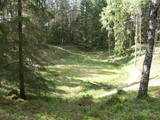 |
There are three craters here, and the biggest one, known locally as Põrguhaud, or Grave of Hell, has a diameter of 80 m and a depth of up to 12 m. There are barriers around the crater that are several metres high. The other two craters are hard to spot. The craters around 6,000 years old. No scraps of the supposed meteorite have been found, however, and so the origins of the craters cannot be confirmed with certainty.
|
|
 |
This venue produces homemade fruit, berry and dandelion wine from local products and with no preservatives, as well as interesting products such as spicy plum sauce and fruit and berry conserves. Groups of tourists can go on a tour and taste and purchase the products. |
|
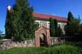 |
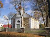
The Archangel Michael Catholic Church of Subate is in the historical centre of Subate. The building, which does not have a tower, was built of fieldstones in 1831, with financing from Count Mikhail Sieberg-Plater. An impressive bell tower was built in front of it. The church contains a sculptural group, “Golgotha,” from the late 18th century, along with a crucifix and a major altar relief that is made of carved wood. It is based on the globally famous Leonardo da Vinci fresco “The Holy Supper.” |
|
 |
Autentiskā Zypliu muižas vidē izveidots restorāns. Kulinārais mantojums - Lietuvas muižniecības ēdieni. Ēdināšana, degustācija, izglītības programmas. |
|
 |
The forests of Zvārde are located on land which used to be a Soviet air base. The territory was unpopulated and was not accessible to civilians. The vast area includes various types of forest - boreal forest, bogs of black alder, etc. The fact that the military used to control the territory is one of the reasons why the forests of Zvārde are a location where many rare and protected birds live, reproduce and find food. Some of the elements of the old air base are still in place, including a unique surveillance platform. It is recommended that visitors to the area drive only along general use roads. |
|
 |
A small settlement with a school, library and shop. North from the Vidale are visible remains of the windmill. Going towards the Gulf of Riga, the road crosses Shlitere Zilie mountain precipice with spectacular views during late autumn, early spring and winter, when there are no leaves on the trees and sandstone outcrops. To the left you can see Zilie mountain spring - a landscaped water taking place. Road that runs from the Vidale to Melnsils side, is called by the locals Knipeldambi. They say that it was built by the German army first During World War I, putting logs on the road and covering them with sand. |
|
 |
St. John the Baptist Roman Catholic Church of Nagļi was built
in 1862 by landlord Nābels. Some time ago, Nagļi Church was a branch of Viļāni Church. The Bernardian
monks served there. After the closing of the cloisters in 1930s, the church was served by priests.
|
|
 |
This pyramid-shaped hillock with an observation tower at the top of it was established by the Soviet military. It is along the Ķevele-Saldus road, where the Zvārde airfield used to be located. It was used as an observation facility to co-ordinate army training manoeuvres. There is a view of the former airfield and the massive forests of the Zvārde Nature Park and nature reserve. It is an appropriate location for bird-watching. Note that there are no improvements there.
|
|
 |
Covered with rocks and with small capes and inlets, this is the eastern shore of the Bay of Rīga and the only place in Latvia where sandstone outcrops are found. These are the result of the abrasive effects of waves between Tūja and Vitrupe. Among the most distinguished of these outcrops are the Veczemi cliffs, which are less than half a kilometre long and up to four metres high. The area has been improved for tourists. It has to be said that this part of the shoreline changes very often, particularly after large storms.
|
|
 3 days
|
The tour starts at Jaunmokas Castle estate, where you will also find the Forest Museum. The pride of the castle is its unique painted tile stove (beginning of the 20th century) made of 130 painted tiles featuring 50 different views of the cities Rīga and Jūrmala. The Forest Trails runs along smaller tracks through the Austrumkursa Uplands, the valley of the river Slocene, along Lake Sekļa and Lake Jumprava to finally reach the town of Tukums. Well, the town takes pride in its pots, planters and flower beds with blooming roses along its streets. Next, the route meanders through forests to the demanding hillock of Milzkalns and Lake Valguma, where you will find the barefoot trail and a secluded art space within the woods. The Forest Trail continues to make a stopover at the Ķemeri National Park. The park is dedicated to protection of wetlands, since it is home to one of the largest marshlands of Latvia – the Great Ķemeri bog. As to the town – Ķemeri – it is the former balneological and sulphur springs resort. The tour ends in the village of Bigauņciems, where the Forest Trail joins with the Baltic Coastal Hiking Route (E9 European long distance path). Optionally, one can take a detour along the Lake Sloka trail with its bird-watching tower or pay a visit to the “Forest House” – the visitor’s centre of the Ķemeri National Park. |
|
 |
The grave of Ida Apsāne, who was known as the “moon daughter” of the great Latvian poet and playwright Rainis can be found in the old Lašu Lutheran Cemetery, which is 200 m to the North of the Lašu Lutheran Church. The text on the grave reads “Ida Marie Apsahn, b. March 23, 1867, d. April 10, 1887.” Other members of her family are also buried here. |
|
 |
Seda is one of the most unusual towns in Latvia. It began its life as a housing area for people from the local peat moss factory, and that happened in the 1950s and 1960s. This is a “vivid” example of Soviet architecture, with a central square (complete with a monument to the Leader) and streets radiating from it. Worth a visit is the cultural centre at the end of Uzvaras Street. It is a great example of so-called Stalinist Classicism architecture. |
|
 |
The Kretinga Estate park is one of the oldest ones in Lithuania to have survived to the present days. Established in the 16th and 17th century, it is a mixed-style park that covers 23 ha of land. The southern part of the park has an astronomical calendar with a sundial, a hedge, allies, and flowerbeds and rock gardens with dahlias, peonies, tulips and roses. There are trails for strollers and areas for relaxation. Particularly popular among local residents is the restored fountain in the park. |
|
 |
This is an artificial body of water that was dug in the 1960s to obtain ice for fish processing plants in Kolka. |
|
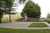 |
The monument is on the side of Rīgas Street in the centre of Piņķi. It is dedicated to May 22, 1919, when, after a pause of nearly two months, a brigade commanded by Col Balodis headed for Rīga to rid the capital city of the Bolsheviks. The brigade was supposed to receive support from the German Landeswehr, the German Iron Division, and the units of Prince Lieven from Russia. The first monument was unveiled by Latvian President Kārlis Ulmanis on May 23, 1939. It was destroyed by the Soviet regime in 1951, but a copy was installed in 2003 (sculptor J. Briedis, copy by O. Skarainis). |
|
 |
The Buse (Matkule) castle hill is next to the Imula River. The hill and the opposite bank of the river offer one of the loveliest views of small rivers in Kurzeme. They are best seen during the season when trees are bare so that leaves do not cover up the landscapes. There are trails for pedestrians in the area. |
|
 |
Baltijā lielākās HES celtniecību uzsāka 1961. g., bet pabeidza 1966. g. Tajā uzstādīto 10 hidroagregātu projektētā jauda bija 825 MW. Pļaviņu HES tiek uzskatīta par unikālu, jo pirmoreiz HES būvniecības praksē tā konstrukcija tika balstīta uz mālsmilts un smilšmālu gruntīm ar maksimālo spiedienaugstumu - 40 m! Pļaviņu HES ēka ir apvienota ar ūdens pārgāzi, zem kuras atrodas Latvijas garākais tunelis - Enerģētiķu iela. 20. gs. deviņdesmitajos gados Pļaviņu HES rekonstruēja un tagad tās jauda ir sasniegusi 870 MW. Apmeklētāji var iepazīt mašīnzāli, skatu laukumus un HES maketu. |
|
 |
Kadarbiku estate is located in Harju, in the municipality Saue, in the village Tula (Tuula). Agriculture started to work here in 1989, while the family company Kadarbiku Köögivili OÜ was established in 2004. Kadarbik farms specializes in growing and processing vegetables. The farm uses 500 hectares of land, which grows carrots, cabbage, beets and various summer crops. They also make juices and smoothies. |
|
 |
Atrodas Taurenē, Gaujas labajā krastā. Muižas apbūve, kurā ietilpst pils (19. gs. 80. gadi, arhitekts – R. G. Šmēlings, historisma un neoklasicisma stils), senie alus pagrabi, klēts, vecā pils un parks, veidojies 19. - 20. gs. Šobrīd muižas pilī atrodas Taurenes pagasta pārvalde un kultūras nams. Muižas kompleksā ietilpst ēka, kurā atrodas Vecpiebalgas novada tūrisma informācijas punkts un Taurenes novadpētniecības ekspozīcija (senajā ledus pagrabā). Parkā (ziemeļos no pils) uzmeklējams piemiņas akmens, kas veltīts komunistiskā terora upuriem. Pie Nēķena muižas sākās 0,4 km garā Cieres dabas taka, kas iepazīstina ar Gaujas krastu mitrājiem. |
|


