
| No | Name | Description |
|---|---|---|
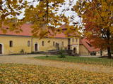 |
The estate in Milzkalne that is along the banks of the Slocene River dates back to the 15th century, when it was built as a closed complex for the Livonian Order. It is the only fortified estate of its type to have survived to the present day, and it was once used as a hiding place for aristocrats during an attack. The gate towers with their ornate weather vanes were built in the late 17th century, and the ancillary buildings date back to the 18th and 19th century. A brick wall with firing apertures survives. The Latvian Road Museum is in one of the wings of the complex, while the former mansion offers accommodations, tours and tastings of local goodies. |
|
 |
The Kauguri canal dug in 19321933
to divert the waters of the Džukste and
Slampe rivers to the Lielupe River to avoid
broader emergence of swamps.
|
|
 |
The Slocene River flows through Lake Valgums and Lake Mazezers before flowing into the western part of Lake Kaņieris. It is part of a branched and swampy delta in which there are seasonal restrictions aimed at protecting birds. The wetlands which are alongside the river are difficult to access in many places. Before the Starpiņupīte was dug between Lake Kaņieris and the Bay of Rīga (the water level is regulated with sluices), the water from the river flowed along what is now the Vecslocene River all the way to Sloka, where it ended at the Lielupe River. The Vecslocene can be used by canoe boats only when the water level is high and then from the Old Ķemeri road to the place where the river enters the Lielupe. Between Milzkalne and Lake Valgums, the river is not navigable because of many fallen trees. During the springtime, the estuary of the Starpiņupīte is a good place for bird watching. |
|
.JPG?size=160) |
This park was established mostly to protect a wide range of cultural and historical objects such as the Trakai lake castle, the ancient Trakai cloister, the Užutrakai castle, the Bražole castle hill, the heritage of ancient local tribes, etc.
|
|
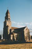 |
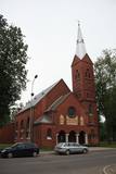
The church was built of fieldstones between 1908 and 1925 in the Tudor Neo-Gothic style (designed by the Liepāja-based architect Stadmann). It replaced a wooden church that dated back to 1621, and its steeple offers a lovely view of lakes that surround the village of Višķi. |
|
 |
The church was built between 1932 and 1938 to replace an old Neo-Gothic wooden church. It was designed by J. Cīrulis. Until 1994, the building housed a venue that rented out films. Today it houses an exhibition, “From Foundations to the Steeple: Photographs of Ancient Lettigalian Construction Jobs.” This documents the construction of the church. The 37 metre steeple offers a good look at Rēzekne. |
|
 |
Apmeklētāju centrā var iegūt noderīgu informāciju un iepazīt ekspozīciju par Karulas augstienes veidošanās vēsturi, ezeru iemītniekiem un šejienes novada kultūrvēsturiskajām tradīcijām. Apmeklētāju grupas semināru zālē var noskatīties izzinošu prezentāciju. |
|
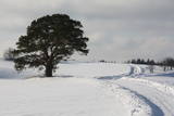 |
This is an unusually shaped pine which, according to legend, was planted by the king of Sweden during the Great Northern War.
|
|
 7 days
|
Этот маршрут предлагает вам отличную возможность посетить самый большой остров Эстонии – Сааремаа, который является своеобразным символом для туризма по Эстонии. На острове находятся один из наиболее впечатляющих метеоритных кратеров в Северной Европе, Епископский замок Курессааре, самая крутая отвесная скала в Эстонии и множество других интересных туристических объектов. |
|
 |
The word zivis means fish, and the name of the street is derived from a fish market that once existed at the end of the street near Kurši Square. There are old log warehouses in the yard of Zivju Street 4/6 and the yard of Peldu Street 2. One of the most popular destinations for tourists is the Latvian alley of fame for musicians (since 2006), with bronze replications of the palms of hands of 35 Latvian musicians. There are ten plaques dedicated to popular bands in Latvia, with five others focusing on musicians who have passed away. The largest guitar in Latvia is right nearby. |
|
 |
Das einzige Museum solcher Art im Baltikum. Das Ziel des Museums besteht darin, die Mensch(und litauisches Volk)-Kosmos-Beziehung zu zeigen. Ausbildungsprogramme, mythologische Steine. |
|
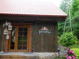 |
The tavern is located in the old log building close to Liepupe Church. There is an old cattle-shed next to the tavern where we make meat and sausage products that you can purchase in the Sudrabņi meat and sausage store. We offer tours and tastings. |
|
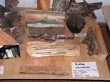 |
The Lejas Kleperi farm straddles the boundary between the Cēsis and Valka Districts. The farm is 119.4 hectares large, with 86.1 hectares of forestland. The farm’s work is centred on forestry. In 1992, a private museum of farming and forestry equipment was set up in one of the residential buildings. The museum’s collection is constantly being updated.
|
|
 |
Centre stage on the a la carte menu of the restaurant is devoted to premium quality game meat dishes. Fish lovers will enjoy just caught Siberian sturgeon in the Sangaste Loss pond, ensuring that ingredients are always fresh. Ancient cooking techniques, such as baking on a bonfire in natural smoke, are honoured. |
|
 |
Das beinah 100 km langes und bis zu 36 km breites aus dem Süßwasser bestehende Haff, das im Norden mit der Ostsee verbunden ist. Das Haff trennt vom Merr die eindrucksvolle Kurische Nehrung. Ins Kurische Haff mündet der größte Fluss Litauens Nemunas ein. |
|
 |
The "Stender's" bar is situated in the centre of the city of Kuldiga at the start of Liepājas Street, which is the main pedestrian and biking thoroughfare in Kuldīga. The two-story wood building was once a granary and is of architectural importance. The bar is situated on the second floor of the building, with the lowest door jambs in Kuldiga and wooden shears in the bar. Latvian cuisine: Farmer’s breakfast, oatmeal, cold kefir soup, sorrel, cucumber and bean soup, beef in onion sauce, hunter’s sausages, potato pancakes, sweet pancakes with lingonberry sauce. |
|
 |
In the small town of Pļaviņas, at the place where the Skanstupīte River flows into the Daugava (Friendship Park), there are the remnants of a set of small and low fortifications known as the Swedish bastions. This was a place of military and political importance, because here was the place where the boundaries of Vidzeme (under Swedish rule), Latgale (under Polish rule), and the Duchy of Kurzeme (on the opposite side of the river) all came together. In 1625, the Swedes were defeated by the Poles here, and Swedish King Gustav Adolf almost lost his life. Medieval bastions of this kind can be seen in some other places of Latvia, as well.
|
|
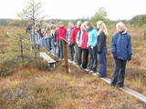 |
The tower is locatede in the Niedrāji-Pilka swamp. Access it via the old Ainaži-Valmiera-Smiltene narrow gauge rail line, which dates back to 1912, and then take the wooden footpaths which are approximately one kilometre long. This is a high-type swamp with small lakes at the foot of the tower. It is in the ZBR. |
|
 |
The guesthouse is on the shore of the Ancient Amata River Valley, and it was built with natural materials – local dolomite blocks. It serves ecological foods, including potatoes grown in bio-humus, wild berries and mushrooms, and country treats and greens from the guesthouse’s own garden. Latvian cuisine: Baked and grilled trout, beefsteak, wild mushroom and chanterelle sauce. Special foods: A puffy Eglaine cake made of rural eggs, pecan cake with ice cream. |
|
 1 day
|
This section of the Baltic Coastal Hiking Route is a comparatively short hike across a beautiful sandy beach, the coastal side of which is bounded by brightly colored pine forests with spectacular dunes and dams of dunes. To get from the beach to Carnikava, the Baltic Coastal Hiking Route will take you through a forest via a promenade. Then it takes a stroll around the Old Gauja River via a levee and reaches the pedestrian bridge over the Gauja River. Both as you start and end the hike, it is nice to sit in one of the pubs and summer cafés located on Vecāķi beach and in Carnikava. |
|


