
| Nr | Name | Beschreibung |
|---|---|---|
 |
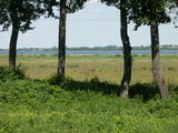
Nemunas bildet sich bei der Mündung ins Haff ein einzigartiges Gebiet mit Mooren, alten Flußarmen, Lagunenseen, Flußauen und der Rusnė-Insel, das ein bedeutender Erholungsplatz für Zugvögel ist. Im Frühling stehen große Fläsche unter Wasser. |
|
 |
The Buse (Matkule) castle hill is near the Imula River. From the castle hill and from the opposite shore of the river, you can find one of the loveliest views of Kurzeme’s small rivers. Their appearance is best when trees and other flora are bare and the view is unimpeded. A wonderful view of the Imula valley is also seen on the road to the castle hill – near the Buse homestead.
|
|
|
|
Atrodas Skuķu ezera ziemeļaustrumu krastā. No torņa labi saskatāms aizaugušais Skuķu ezers ar nelielām ūdens lāmām un ūdeņiem bagātos pavasaros pārplūstošā Dvietes paliene. Laba putnu vērošanas vieta. |
|
 |
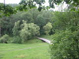
The Mežotne castle hill is on the left bank of the Lielupe River and opposite the Mežotne Castle. This was one of the largest Semigalian fortified castle hills during the 9th to the 13th century, and an ancient town alongside the hill covered 13 ha of land. The castle hill has been improved. A pontoon bridge across the Lielupe allows hikers and bikers to reach the castle (between May and October). Vīna Hill is approximately 500 m to the South of the castle hill, and a wooden pathway leads to it. |
|
 |
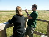
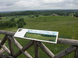
This is one of the highest points among the hillocks of the Selonian area of Zemgale – Borīškalns Hill. From the tower, you will see Lake Sauka, as well as the forests and farmland which surround it. The “Kalna Ļūdāni” farm is nearby, and its owner uses his livestock to help to maintain the surrounding landscape.
|
|
 |
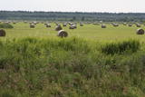
There are three large lakes at the centre of this park – Lake Dusia, Lake Metelys, and Lake Obelija. Lake Dusia has very clear and transparent water, and its southern and south-eastern beaches are popular among swimmers. The lakes and their nearby wetlands are important during the migration season of birds.
|
|
 |
Ein mit Wäldern und Seen reiches Gebiet im Nordteil der Dzūkija-Anhöhe. Das Täufelsbeet (Velnio duobė) ist eine bis 40 m tiefe und 200 m breite trichterförmige Grube, die Entstehung der mit einer Tätigkeit eines urzeitlichen Gletschers verbunden ist. |
|
 |
Veisieji reģionālais parks (Veisiejų regioninis parkas) veidots (1992.g.) Sudavas augstienes (Sūduvos aukštuma) ainavu, bioloģiskās daudzveidības un kultūras pieminekļu aizsardzībai. Viena no parka bagātībām ir ezeri, kuru iegarenās formas liecina par ledāja darbības rezultātu. Pēdējā apledojuma laikā šeit atradusies ledāja mala. Ezerus (kopā – 37) ieskauj lielāki meža masīvi uz kontinentālām (iekšzemes) kāpām, kas piemēroti atpūtai dabā, dabas vērošanai, ogošanai un sēņošanai. Parkā ir iekārtotas peldvietas, kur patīkami gremdēties vasaras tveicē, izveidotas dabas takas, bet mazās upītes, kas savieno ezerus, ir piemērotas braucieniem ar kanoe laivām. Veisieji reģionālā parka teritorijā ir liela augu un dzīvnieku daudzveidība. Šeit tiek aizsargātas arī tādas retas sugas kā Eiropas kokuvarde Hyla arborea (parka simbols), purva bruņurupucis Emys orbicularis, dažādas orhideju sugas u.c. |
|
 |
Der Tērvete Naturpark befindet sich in einem Gebiet, das nicht besonders typisch für die Zemgale Region ist – im Tērvete - Flusstal. An seinen Ufern gibt es riesige Wälder, die sich gut für Freizeitaktivitäten eignen. Es gibt Naturdenkmäler und auch hervorragende Kultur- und Geschichtsdenkmäler in dieser Gegend. Der Tērvete Landschaftspark ist einer der beliebtesten touristischen Ziele in Zemgale. Die Besucher finden hier einen Wald mit uralten Kiefern, einen herrlichen Landschaftspark, das Sprīdīši-Arboretum, die Burgberge von Tērvete, Klosterkalns and Svētkalns, das Museum “Sprīdīši”, das der großartigen lettischen Autorin Anna Brigadere gewidmet ist, verschiedene Kinderattraktionen, schöne Landschaften, ein enges Netz von Wanderpfaden usw. Dieser Naturpark ist 2004 zum familienfreundlichsten Ort in Lettland ernannt worden.
|
|
 |
It is rare type of lake in Latvia and there are only of few this type of lakes in Kurzeme region. The lake is characterized by high water limpidness (very attractive for tourists) and very rare plant species for Latvia. Nature park includes the lake, costal area and forest on the East from the lake, few smaller lakes and Sarlote Pond. There are several tourist accommodations located around the lake.
|
|
|
|
Tītuvēnu reģionālais parks (Tytuvėnų regioninis parkas) dibināts 1992. gadā. Parkam raksturīga ainavu daudzveidība – te ir sastopami lieli mežu masīvi, purvi, ezeri, upītes. Šejienes reljefa veidotājs tāpat kā citur Baltijas valstīs ir bijis ledājs, kas atnesis un atstājis aiz sevis garas laukakmeņu grēdas. Kopumā parkā ir konstatētas 603 augu un 787 dzīvnieku sugas. Parkā aug veci un dabiski boreālie (ziemeļu) meži, veci un jaukti platlapju meži ar ozoliem, liepām, kļavām, ošiem un gobām, sugām bagāti egļu meži, staignāju meži, nogāžu un gravu meži, purvaini meži un aluviālie (pārplūstošie) meži. Parkā esošās pļavas un tīrumi ir nozīmīga dzērvju atpūtas vieta migrāciju laikā, kad te pulcējās tūkstošiem putnu. Šiluvas baznīca un Tītuvēnu klosteris ir svētceļnieku galamērķis vairāk nekā 500 gadu garumā. |
|
 |
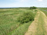
Open landscape area within farming lands on both banks of Uzava River about 10 km before it flows into the Baltic Sea. There is a good open view over the area from the Vendzava-Ziri road going through the nature park. Protection of migratory birds and corncrakes has been one of the main reasons for establishment of the nature park. Bird watching is possible from the road Vendzava-Ziri during migration period in spring and fall. There is no tourist infrastructure in the nature park.
|
|
 |
The key treasure in this park is that it has a lake that is one of the most intensive sites for birdwatchers in all of Latvia. It also features outstanding flora and the shallow waters of the Bay of Rīga. Recommended: Hike along the seashore from Mērsrags to Engure (20 km). See wild domestic animals (horses and cows) on the eastern shore of Lake Engure. There’s a bird-watching tower on the NW shore of the lake (approach from Kūļciems, where you can see domestic animals adapted to life in the wild, including the Blue Cows of Latvia). A bird-watching tower can be found at a place called Jomiņa near Mērsrags, where the seashore meadow is an uncommon biotope
|
|
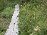 |
Teritorijas apskates nolūkos ir izveidota un labiekārtota dabas izziņas taka. Dabas liegums atrodas Abavas senlejas dabas parka teritorijā. Taka iepazīstina ar vienīgo krūmu čužas savvaļas augšanas vietu Latvijā. |
|
|
|
The mouth of the most beautiful river of Vidzeme. On the seashore between the mouths of River Gauja and River Daugava, one of the largest dune ranges in Latvia with distinctive parabolic dunes overgrown with forest (wooded dunes) is situated. The Mouth of River Gauja is unique as it is one of the few major rivers in Latvia and in EU countries to flow into the sea naturally. There is no harbour or other hydro-engineering construction. It is a popular recreation area in the vicinity of Riga and Saulkrasti while, unfortunately, the lack of infrastructure makes it suffer from anthropogenic load. Not far from the rivermouth, hidden in dunes, there are pillboxes which were built in 1920 or 30ies as anti-airborne barriers. There was a whole range of them along the coastline from the mouth of the River Lielupe to the mouth of the River Gauja forming a part of the Daugavgrīva Fortress fortifications. The pillbox is made of concrete, ca 1.5m thick. Every year, on the 3rd Sunday in August, a lamprey festival takes place in Carnikava town by the Gauja rivermouth. Carnikava is called the Lamprey Capital as it is famous for its lamprey fishing tradition and generous catches. The Mouth of the River Gauja is a good bird-watching area, especially in spring and autumn when one can observe the highest variety of species. Just few of the many bird species that can be observed near the Gauja rivermouth |
|
 |
Dieses Territorium soll die “grüne Zone” von Riga schützen. Der größte Teil des Parks ist mit Kiefernwald und Dünen mit Sträuchern darauf bedeckt. Der See Beberbeķi befindet sich im südlichen Teil des Parks. Das Gelände um den Park herum wurde verbessert.
|
|
 |
Dieser Park befindet sich im ausgeprägtesten Teil der Dagda-Hügel des Latgale-Hochlandes. Teil davon ist der tiefste See der Baltischen Staaten – der See Drīdzis, der 63,1 m tief ist und neun Inseln hat. Dort befindet sich ebenfalls der See Otis. Den hübschesten Blick hat man vom alten letgallischen Burgberg, der als Sauleskalns-Berg bekannt ist und vom Ostufer des Sees Drīdzis. Unterkünfte gibt es in der Nähe des Sees.
|
|
 |
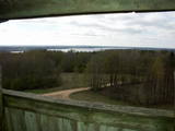
The viewing tower is in a seaside meadow near Mērsrags. It is an unusual type of biotope in Latvia and is located to the North of the Mērsrags port. The tower offers a good view of reed-filled meadows, areas where wild cattle have grazed, and an amazing wealth of different kinds of plants. |
|
 |
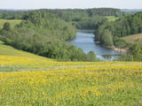
This park is in a region of hillocks in the Karula highlands, and Lake Ähijärve is at its centre. The park offers a cultural environment of small farms, and it was set up to protect the unique cupola-shaped hillocks of the area. Main attractions: Scenic Lake Ähijärv (176ha), Rebasemõisa Tornimägi hill (137.8 m above sea level), undulating landscapes. |
|
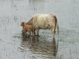 |
Der flache und fast zugewachsene See Engure (65% seiner Oberfläche) ist einer jener lettischen Seen, die vor allem von Vögeln bevorzugt werden. Es ist eines der Terrains, die von der Ramsar-Konvention über Feuchtgebiete verwaltet werden. 186 Arten von Nistvögeln wurden hier ermittelt. Das Gebiet zeichnet sich auch durch eine große botanische Vielfalt aus (mehr als 800 Pflanzenarten). An der Küstenlinie wechseln Sandstrände mit Küstenwiesen ab. Es gibt Wälder, Fischerdörfer, Feuchtgebiete, die die große Vielfalt der Landschaften und Arten sichern. Die Auen des Sees und des Meeres sind Weideland für Wildtiere - Pferde, blaue Kühe usw. MehrereVogelbeobachtungstürme stehen Besuchern zur Verfügung, ebenso der Orchideenpfad.
Die Ornithologische Forschungsstelle liegt am Ostufer des Engure-Sees. Eine einzigartige schwimmende Station - von Ornithologen gebaut - befindet sich auf dem See. Die Landschaft ist nicht nur für Urlauber, sondern auch für Wanderer, Radfahrer und Vogelbeobachter geeignet. Ein Erholungsplatz und eine kleine Ausstellung befinden sich neben der Ornithologischen Forschungsstelle. |
|


