
| No | Name | Description |
|---|---|---|
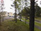 |
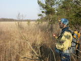
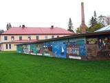
The biography of Krišjānis Valdemārs tells us that during the summer of 1839, teachers and students from the Lubezere school spent a few days on the coastline in Roja, where Valdemārs would later help to build a maritime school. The area was breath-taking and unforgettable for the little boy. “The noble appearance of the sea grabbed the spirit of the young man so powerfully that during those three days, I thought about nothing other than the noble sea, with childish courage that allowed me to prepare a plan for a deeper port in the Roja River so that larger boats and small ships could enter it,” Valdemārs wrote. (Source: Roja TIC) |
|
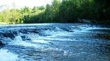 |
35 m wide and 0.5 m high, the
|
|
 |
Based on the tower of a former Soviet army radar installation, there is an 18-metre viewing tower at the Southern breakwater of Ventspils (Medņu Street) today. The tower offers a good view of the port territory, with the sea gate at the mouth of the Venta River and the city beach. Binoculars are available at the tower. It is worth walking down the Southern breakwater to get a better look at the sea.
|
|
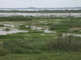 |
The Lake Lubāns depressions which are alongside the lake’s western and south-western parts feature little-changed forests and swamps, where many rare and protected birds nest. Many uncommon and protected habitats are in the region.
|
|
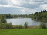 |
This restricted area protects the eutrophic Lake Istra and the biotopes that are alongside it – various kinds of forests and meadows. This is a particularly lovely part of the Latgale region. Interestingly, the so-called system of “rope farms” can still be seen in the nature park.
|
|
 |
Pokaiņu mežs atrodas 13 kilometru attālumā no Dobeles, braucot Īles virzienā. Tas, izvietojies uz stāviem pauguriem un dziļām ielejām, veido neparasti gleznainu ainavu. Mežā grupās, kaudzēs, akmens upēs un valnīšos, atrodas slavenie Pokaiņu akmeņu krāvumi. Krāvumi daudziem cilvēkiem liek sajust savdabīgus enerģijas strāvojumus - vieni redz vīzijas, bet citi – uztver informācijas plūsmu. Takas ved pa pagurainu apvidu.
|
|
 |
This lime swamp of grasses is in an area among dunes which floods from time to time, and it is an important location for many protected plants. The swamp is easily surveyed from the forested dunes which are on the south-eastern side of the swamp. |
|
 |
From the 6th century until the 8th century instead of the current Grobina the largest known Scandinavian trade and warrior colony in the Baltic States was located. Settlers from the inlands of Gotland and Sweden established their settlement at the hillock that was then located at the bank of the navigable Alande River. It is believed that the Cours Castle – Seeburg mentioned in the chronicles of the 9th century was located exactly here. After the loss of the order castle in the 13th century Grobina became the centre of the region. The most ancient construction of the city was formed around Lielā Street, as well as around Saules and Parka Streets. |
|
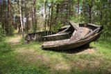 |
In the 1960s, the Soviet Union banned individual fishing in the sea, and the motor boats which had no other purpose were simply beached in the dunes. It is said that members of the Border Guard often set the boats on fire. Another story is that the Border Guard banned an ancient tradition of burning old boats on Summer solstice Eve. Along the road to the cemetery is the old net barn, which is a residential building today. |
|
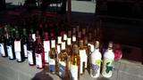 |
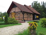
The owner of the venue makes homemade wine on the basis of traditions that have been handed down from generation to generation. You can taste four different wines along with snacks and engage in philosophical discussions about winemaking recipes. You can also buy the wines. |
|
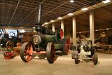 |
This museum offers a look at the Latvian countryside, informing visitors about the history of the development of the agricultural sectors and popularising evidence about farming and life in Latvia's countryside from the late 19th century to the present day. The interest of visitors is facilitated by various equipment used to process the land and harvest and process the crops. There are also various tools. |
|
 |
The café is in the historical centre of Tukums in Brīvības Square. Latvian cuisine: Porridge. |
|
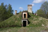 |
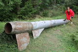
The former Soviet communications division at Plāņciems in the forests of Bārta is privately owned and is being dismantled at this time.
|
|
 |
The “Kukaburra” café is located on the 115th km of the Riga-Veclaicene highway (A2). It is possible to see the Bread museum. Guests can take part in baking rye bread every weekend. The café has a Latvian interior and serves products from local farmers and home-based producers of ingredients. Latvian cuisine: Chicken liver salad, lamb soup, dumpling soup, cold soup, baked catfish, sautéed pork, potato pancakes, pancakes with jam cottage cheese buns, stacked rye bread. Special foods: Home baked rye bread. |
|
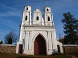 |
Located on the right bank of the Daugava, the church can be seen from various parts of Piedruja. The first wooden church was built at the instruction of Prince Jan Stapekha in 1632, and it burned down in 1759. The Baroque stone church that is there now was built in 1759 with its two towers, and it may have been designed by an Italian architect. The towers stand 27 m high, and under the church is a cellar. The towers have three bells – the largest one dates back to 1711, the middle-sized one was manufactured in 1896, and the smallest dates back to 1619. The largest bell weighs nearly 0.4 tonnes. Inside the church are many important cultural and historical monuments, including a central wooden altar with a painting of the assumption of Mary, three 18th century altars, a pulpit from the early 19th century, St Anton’s altar, a fresco of the Holy Trinity, church dishes from the 17th century, etc. The building is surrounded by a large garden with a stone fence and stone repositories at the corners of the garden. Two priests, Kazimirs Konvalevskis and Broņeslavs Stefanovičs are buried here. Stefanovičs played a major role in the restoration of the church after World War I. The Piedruja congregation first emerged during the first half of the 17th century. |
|
 |
The late 19th C saw an increase in the development of dairy products in Estonia. The Dairy Museum was established in 1976 to preserve, research and exhibit the history of dairy production. Collections are exhibited both indoors and outdoors, our programmes are very popular and guided tours for groups are available on request. Estonian Dairy Museum tells guests about making dairy products at home, displays and exhibitions on dairy history are also available here. The museum also organises sweet cheese snack, cheese, ice-cream and butter making masterclasses. |
|
 |
Manufacture of sausages and smoked pigs. For pig feed, the farm uses home-grown grains (not treated with glyphosates) and unmodified soybeans grown by the farm itself. Sausages and smoked meat and spices. Only natural alder firewood is used in the smoking process. |
|
 |
Der weiteste Nordpunkt der Juminda Halbinsel mit einer Raketen-Attrappe der Sowjetarmee, der alten Grabstätten, dem Juminda-Leuchtturm und einem Denkmal für die Opfern des Zweiten Weltkriegs. |
|
 |
The farm offers a look at angora rabbits, which are very uncommon in Latvia. The owner offers tours, stories, rabbit wool, wool products such as mittens and socks, breeding rabbits and consultations. Children will love the animals and can feed them in the presence of the owner. |
|
|
|
10 km garais pārgājienu maršruts iepazīstina ar vienu no vēl retajiem, cilvēka mazāk ietekmētajiem Daugavas senlejas posmiem. Tā sākums – Aizkraukle, finišs – Skrīveri. Gar upes krastu izvietotas atpūtas vietas. Maršrutu var braukt arī ar velosipēdu. |
|


