
| Нo | Название | Описание |
|---|---|---|
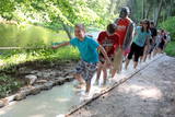 |
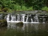
The first barefoot trail created in the Baltic States in the recreation complex "Valguma pasaule", which is located on the forested shores of Lake Valguma. When walking on the path, the feet "massage" sand, wood chips, clay, peat, gravel, cones and various other materials. |
|
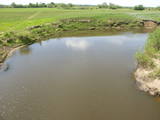 |
The Dviete Wetlands Nature Park contains a unique natural territory – the ancient Dviete River valley with the Lake Skuķi and the Lake Dviete and the surrounding wetland meadows. During flooding season, these wetlands store up waters from the Daugava River. They absorb a lot of floodwater at first and then slowly return it, thus reducing the level of floods in the Daugava River valley. This process is the reason for the unique ecosystem which exists in this area. It is an important location for plants and birds both during migration and nesting season. The river valley is important for birds during migration and nesting. In 2006, wild cows were released into the meadows. There is also work to improve the tourist infrastructure in the area. |
|
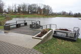 |
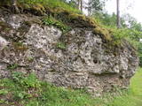
Gar Grobiņas ūdenskrātuvi (Ālandes labais krasts) izveidota mūsdienīga un labiekārtota pastaigu un atpūtas vieta - promenāde, uz kuras izvietotas plāksnes ar Zentas Mauriņas un Jāņa Raiņa citātiem. No promenādes paveras labi skatu punkti uz Skābaržkalnu un Grobiņas pilsdrupām. Grobiņas ūdenskrātuves sašaurinājumā pāri Ālandei ved neliels tiltiņš, kas ir bijušā Liepājas – Aizputes šaursliežu dzelzceļa tilta ferma. |
|
 |
Established: 1959
60 coniferous and 350 deciduous trees
Brief description: Between the Tukums-Kolka road, the Lāčupīte stream and the sea, Igors Mednis has planted a series of foreign trees and shrubs. He has conducted experiments to see how different foreign plants adapt to different conditions. The best time to visit is in May and June, when the rhododendrons are in bloom.
|
|
|
|
No 28 m augstā torņa, kas atrodas uz apdzīvotas „salas” – Siksalas Teiču purva vidū, paveras ļoti plaša augstā purva ainava ar Siksalas ezeru, citām minerālzemes salām un Siksalas mazciemu. Tā kā tornis atrodas Teiču dabas rezervātā, to var apmeklēt tikai Dabas aizsardzības pārvaldes inspektora pavadībā, iepriekš piesakot vizīti T: + 371 28333415. |
|
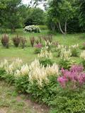 |
The park was founded by the gardener Arvīds Janitens. Professor Raimonds Cinovskis has said that Arvīds is just amazing, because he alone did work that would usually be done by a big group of people. This is one of the most popular tourism destinations of its kind in Latvia.
|
|
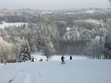 |
Gaiziņkalns Hill is the highest hill in Latvia, and it is a typical example of the hillocks of the Vidzeme highlands. This is a place of wonderful landscapes, even though there are not all that many good viewing areas. At the centre of this park is Gaiziņkalns Hill itself – the highest place in Latvia and the second highest in the Baltic States (311.6 metres above sea level). The viewing tower, alas is not open to the public, because it is in dangerous condition. There is a well-appointed hiking trail around Gaiziņkalns Hill, and during the winter the hill and its surroundings are popular for downhill and cross-country skiing. Lake Viešūrs (Lake Kaķītis) is popular among licensed fishermen. This territory is part of a region of protected landscapes around Vestiena. |
|
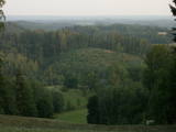 |
From the highest point in the Alūksne highlands, you will see an unusually beautiful view of the surrounding forested hillocks and the small areas of meadows and farmland. Sadly, there are no improvements to the location, which can be difficult to access. It is on private property.
|
|
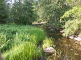 |
A distinct area of the lower reaches of the Vitrupe River, with small sandstone cliffs and many rare species of plants and molluscs. Visitors can visit the Ķirbiži Forest Museum and its information and botany trail. It weaves along both banks of the river and allows people to look at the most typical examples of flora in the region. The noble Vāloži oak tree is a key element there.
|
|
 |
Pokaiņu mežs atrodas 13 kilometru attālumā no Dobeles, braucot Īles virzienā. Tas, izvietojies uz stāviem pauguriem un dziļām ielejām, veido neparasti gleznainu ainavu. Mežā grupās, kaudzēs, akmens upēs un valnīšos, atrodas slavenie Pokaiņu akmeņu krāvumi. Krāvumi daudziem cilvēkiem liek sajust savdabīgus enerģijas strāvojumus - vieni redz vīzijas, bet citi – uztver informācijas plūsmu. Takas ved pa pagurainu apvidu.
|
|
 |
This is a segment of the Gauja River which is full of rapids in some places. It stretches from Vidaga and the place where the Vecpalsa River flows into the Gauja. Along the Gauja and its tributaries, dolomite outcrops can be seen on the shores, and the largest of these are the Randati cliffs. The restricted area was established mostly to protect various kinds of forests, meadows, outcrops and their habitats. This is an interesting part of the central section of the Gauja for people who enjoy beautiful landscapes and for those who are water tourists.
|
|
 |
Доле является самым большим островом на Даугаве. С северо-востока его омывают быстрые воды Даугавы, а с юго-запада – спокойные и понемногу зарастающие воды бокового русла Даугавы. Острову присвоен статус природного парка (Особо охраняемая природная территория). Парк основан в 1987-м году с целью сохранения оставшегося после постройки Рижской ГЭС ландшафта острова и культурно-исторических ценностей, а также редких и охраняемых видов растений и животных. Еще одна цель образования парка – способствование просвещению и отдыху общества. Одним из известнейших объектов осмотра острова Доле является музей Даугавы, размещенный в жилом здании поместья Доле. В коллекции музея находятся ~ 13 000 различных экспонатов – свидетелей истории острова Доле и берегов Даугавы – одежда балтов и ливов, орудия труда, предметы быта. Экспозиция знакомит с историей Даугавы как значимого водного пути, а также с историей плотовщиков и транспортных средств этого пути. В парке поместья Доле размещена музейная экспозиция под открытым небом с реконструкцией заколов для миног и запруды для ловли лосося и коллекцией рыболовных снастей. Возле музея на обрывистом берегу бокового русла Даугавы находится доломитовое обнажение. На юго-востоке острова на берегу Даугавы возле хутора Бечи можно осмотреть руины замка Вецдоле. |
|
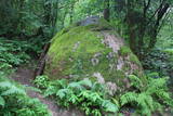 |
200 m attālumā no Gulbenes – Madonas ceļa mežainā nogāzē iegūlis 2,4 m augstais akmens. Tā lēzenajā virsmā iekalta ap metru gara, 0,3 m plata un ap 4 cm dziļa iedobe, bet akmens šķautnē - pakāpieni. Uzskata, ka šis ir sens kultakmens, pie kura ziedots. Lai nokļūtu līdz akmenim, vasaras otrajā pusē var nākties brist pa garu zāli. |
|
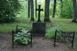 |
К северу от замка Цесвайне раскинулся парк, который пересекает стремительная речушка Сула. На его северном берегу возвышается 15-метровое заросшее лесом Цесвайнское городище с могилой владельца замка Адольфа фон Вульфа. Сохранилось предание о его желании быть отвезенным к месту захоронения в санях. Несмотря на то, что он умер в летнее время, его желание было реализовано. В парке произрастает множество различных видов деревьев и кустарников. Часть из них из своих путешествий привез сам хозяин замка. |
|
 |
The ancient Abava River Valley between Kandava and the place where the river flows into the Venta River is the most expressive river valley segment in Kurzeme in terms of landscape and terrain. The valley is 30 to 40 metres deep and as much as 300 metres wide. The territory is distinguished by great diversity of a biological nature (more than 800 kinds of plants), featuring many different biotopes and natural monuments such as streams, waterfalls, cliffs, huge rocks, and many cultural and historical monumentssmall towns such as Kandava and Sabile. In both cases, the town centres are national monuments of urban construction. Popular tourist destinations include Vīnakalns hill in Sabile, where wine-making grapes are grown, as well as the open-air art museum at Pedvāle. To protect cultural treasures, a cultural and historical territory, “Abava River Valley” has been established. Wild livestock live at Drubazas and Tēvkalni to “maintain” the landscape. There are nature trails for tourists, and the Abava is the most popular river for water tourists in Kurzeme. Information is available at the tourist information centres in Kandava and Sabile. such as castle hills, churches, ancient burial grounds, and
|
|
 |
Селга к западу от Туи – важная территория для защиты малой чайки в период весенней миграции. Территория расположена напротив Салацгривского, Лимбажского, Саулкрастского и Царникавского края, ее площадь составляет 58 600 га.
|
|
 |
Nītaures vēstures takā var apskatīt un iepazīt dažādus vēsturiskus objektus no 13.gadsimta līdz mūsdienām - seno pilskalnu, vācu ordeņa pilsdrupas, luterāņu un pareizticīgo baznīcas, soda vietu un muižas seno apbūvi. |
|
 |
Elka Hill is one of the highest surfaces in the western part of the Vidzeme highlands, and it offers a lovely and broad view to the North. There is a small parking lot, a TV and radio tower, and the place where the Gauja River is thought to originate.
|
|
 |
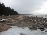
The Sunset trail starts in the centre of Saulkrasti town and takes you to the White Dune. Saulkrasti town with its municipal rural territory, occupies a 17km long stretch of coastal land to the North from the river Lilaste and the lake Lilaste. The White Dune stands on the right side of river Inčupe mouth. It is covered by old pine forest. The white, 18m high sand outcrop in olden times served as a landmark for fishermen. The White Dune formed as winds carried the sand from the beach over clay sediments of the Baltic Ice Lake. Some 150-200 years ago, the dune had been drifting as witnessed by several layers of soil buried within it. Local fishermen and farmers at Bātciems initiated afforestation of the drifting dunes. At that time, the 30m high dunes which are now covered with forest, were bare, shifting and even buried a farmstead. To speed up afforestation, mountain pines were planted. The White Dune was partly washed away in heavy storm in 1969, and 4-6m high precipice formed. Now the wind and sand have levelled out the dune surface, it has been fixed with willow-twigs or grown with forest where the largest pines are more than 170-190 years old. The pines are notable with their large trunks and branches, the scars obtained during their lifetime and the typical “crocodile skin” – the bark forms rhombuses resembling those of the reptile’s scales. Scots Pine (Pinus Silvestris) is one of the most common tree species in Latvia. It grows in dry, meagre sandy soil in dunes as well as in marsh. However, it does not stand overshadowing. Forest fires help pines to get rid of competitors as pine endures fire better than other trees because of its thick bark and high crown. The wood exudes resin and burned wounds close soon. Fire cleans space for seedlings of young pines. Pines can live 300-350 years. Ground cover in dune forests is very sensitive. If the sparse vegetation is destroyed, not only the natural biodiversity and landscape is damaged, but also the dangerous shifting dunes can possibly “wake up”. Embryonic dunes, White (yellow) dunes, Grey dunes and Wooded dunes are EU protected biotopes. Grey Dunes are protected by Latvian law as well. |
|
 |
The Tērvete Nature Park is located in an area which is not particularly typical of the Zemgale region – the distinct Tērvete River valley. Along its banks there are vast forests which have been nicely adapted to leisure activities. There are natural treasures, as well as an outstanding cultural and historical heritage in the area. The Tērvete Nature Park is one of the most popular tourist destinations in Zemgale. People are interested in the Park of Old Pines, the lovely pine forest, the Sprīdīši arboretum, the Tērvete, Klosterkalns and Svētkalns castle hills, the memorial museum “Sprīdīši” which commemorates the great Latvian author Anna Brigadere, various attractions for children, lovely landscapes, a dense network of pathways, etc. The nature park was nominated as the most family-friendly location in Latvia in 2004. |
|


