
| Nr | Name | Beschreibung |
|---|---|---|
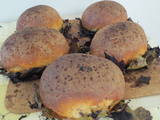 |
Die Bäckerin bäckt nach traditionellen Rezepten Brot und Sklandrausis auf Ahornblättern. Die Sklandrausis bestehen aus Roggenmehl, Kartoffeln und Möhren. In der Bäckerei wird der Prozess der Fertigung von Brot und Sklandrausis vorgeführt, woran anschließend die Besucher die frischen Erzeugnisse verkosten und kaufen können. Daneben werden traditionelle Trachten der Suiti, Spiele und Lieder gezeigt. |
|
 1 Tag
|
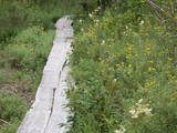
Tūrisma gide Ineta Jansone piedāvā ekskursijas grupām uz Melnalkšņu dumbrāja laipu. Melnalkšņu dumbrāja laipa ir viena no īsākajām un interesantākajām takām Ķemeru nacionālajā parkā (600 m). Melnalkšņu dumbrājā Vēršupītes krastos novērojami dabiskam mežam raksturīgi elementi – jauni, kā arī veci un dobumaini koki, kritalas, sausoņi, ciņi. Daudzveidīga ir meža putnu fauna. Jebkurā gadalaikā melnalkšņu dumbrājs ir īpašs. Taču visā krāšņumā dumbrājs atklājas tieši pavasarī. Vēršupītes pālu laikā ūdeņi pārklāj lielāko dumbrāja daļu, bet visapkārt zied zeltainās purenes, gaiss vibrē no putnu dziesmām un dzeņu bungošanas. |
|
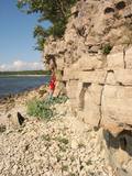 |
Nacionālā parka dienvidrietumdaļā jūrā iestiepjas Eldas pussala – skaists un ļoti omaļš ar kadiķu mežu (alvāriem) noaudzis zemes pleķītis ar interesantu jūras krastu, kur atsedzas silūra perioda nogulumieži. No pussalas gala, kurā slejas vecs Padomju armijas robežsargu tornis (apmeklējumam bīstams!), paveras visaptverošs skats uz Vilsandi salu (atpazīstama pēc bākas), Lonalaidas salu (Loonalaid) – otru lielāko Vilsandi arhipelāgā, Salavu (Salava) un citām mazākām saliņām. Dabas mīļotāji var uzmeklēt Eldas klinti (Elda pank) – ~ 2 m augstu un 0,4 km garu atsegumu, kura piekājē var atrast interesantas ūdens izskalotas fosilijas. |
|
 |
Befindet sich in Skrīveri, Daugavas Straße 58. Das erste Haus des Schriftstellers (1877 – 1970) wurde 1908 gebaut, aber jetziges Haus – im Jahre 1921 auf der Grundlage des ersten Hauses. Im Gebäude ist ein Museum eingerichtet. Die Exposition des Museum veranschaulicht einen Lebens- und Schaffensweg des Schriftstellers, sowie wie der Roman “Grüne Erde” erschaffen wurde. Neben dem Haus ist ein Garten.1952 hat der Schriftsteller das Haus mit dem Garten der Staat geschenkt. Es werden Führungen und museumspädagogische Programme angeboten. |
|
 |
Saimniecība nodarbojas ar sporta zirgu audzēšanu, sniedz zirgu viesnīcu pakalpojumus un var nodrošināt zirgu izmitināšanu brīvā dabā 24/7. Tiek audzēti kumeļi no augstvērtīgiem ērzeļiem: Aromāts (Acorado/Capiotol I), Fumo Twirre MP (Numero Uno/Voltaire), Cool Crack Z (Cornado I/Cassini II). Saimniecībā tiek izmitināti arī citi lauksaimniecības dzīvnieki, kurus viesiem ir iespēja apskatīt, samīļot un pacienāt ar gardumiem. Ir iespēja baudīt lauku gaisotni un apgūt iemaņas, kā izaudzēt veselīgu pārtiku - olas, gaļu, garšaugus. Piedāvājumā arī piknika vietas, noma korporatīviem pasākumiem un bērnu ballītēm, telšu vietas un aktīvās atpūtas iespējas. Ikdienā apkalpo tikai individuālus viesus vai korporatīvus pasākumus, saimniecība netiek piedāvāta plašākai apskatei. |
|
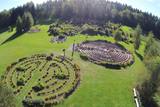 |
Im Park befinden sich fünf Labyrinthe, die mit Zierpflanzen geschmückt, mit Blumen und Heilkräutern bepflanzt sind. Dabei handelt es sich um Thymian, Phlox, Pfingstrosen, Beinwell, Hartheu, Pfeifenstrauch, Zierquitten, Brennende Liebe, Eisenhut, Dost, Estragon, Schlüsselblume, Rainfarn, Schöllkraut, Alant, Minze, Goldrute, Mädesüß usw. Der längste Pfad in dem energetischen Labyrinth ist 1,7 km lang. Und wenn man alle 5 derzeit vorhandenen Labyrinthe durchlaufen will, kommt man auf knapp 5 Kilometer. Im Park sind 3 geometrische Figuren eingerichtet: Kuppel, Mandala und Merkaba. |
|
 |
The Krimulda Castle was built in the latter half of the 13th century. It was located where the right bank of the ancient Gauja River valley is split by the deep Vikmeste ravine. The castle was owned by the council of archbishops from Rīga, and it was an impressive structure with a large interior courtyard and a defensive wall that was 1.5 m thick. The Swedish military blew up the castle when retreating in 1601. Today the castle hill is forested, and only a small fragment of the castle wall can still be seen. It is near the ruins that you will find the Sigulda aerial tram and the Krimulda serpentine road – the only object of its kind in the Baltic States. |
|
|
|
This is the 11th largest Estonian island, and its central section is covered by a broadleaf forest (linden, oak, elm and other trees) that is more than 100 years old. Along the shores, the Abruka Island has meadows and small areas of wetlands. Only the northern part of the island is populated. Few tourists come to call, which means that the island is relatively untouched by humankind.
|
|
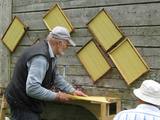 |
In der Imkerei werden verschiedene Programme angeboten, hier kann man das Leben der Bienen besichtigen und hören. Man kann sich auch richtig als Imker fühlen, mit der entsprechenden Kleidung und dem glimmenden Smoker kann man den Imker bei der Arbeit begleiten und diese selbst ausprobieren. Zudem kann man diverse Bienenprodukte verkosten und beim Honigschleudern mithelfen. Außerhalb der Saison beschränkt sich der Besuch auf dem Hof natürlich auf den Besuch und das Verkosten der Bienenprodukte sowie die Herstellung von Kerzen aus Bienenwachs. |
|
 |
This is one of the most outstanding areas in the entire Baltic States with active underground waterways which still, to this very day, dissolve local gypsum rock. Parts of the area collapse regularly, and there are legends about all of this. Underwater rivers, streams, the so-called Karvės (Cow) cave, etc., can be seen in the area.
|
|
 |
Der Schießstand – am Parkplatz bei dem Naturpfad, kann ein
aufmerksamer Besucher eine zuwachsende breite Schneise sehen, die vom
Strand bis zur Straße Ventspils – Kolka geht. Dieser Platz wurde in der
Sowjetzeit als Schießlehrplatz benutzt.
|
|
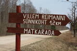 |
Kultūrvēsturiska taka (garums ~ 2 km) Tipu (Tipu) ciemā, kas iepazīstina ar vairākiem interesantiem objektiem: veco skolu (1931. g.), Hallistes upi, pirti un Paunas saimniecību, kurā dzimis viens no Igaunijas nacionālās kustības līderiem Villems Reimans (1861. – 1917.). |
|
 4 Tagen
|
This is for birders who can’t afford to take longer breaks to enjoy birdwatching. Short but rewarding trip during spring migration. Cape Kolka is a place where pass the largest numbers of migrating birds in the spring time. More than several tenth of thousand birds cross the Cape each hour. During active period of migration it is possible to see more than 100 different species daily just at this one place. There are several birdwaching places located at different biotops – seaside meadows, sea cost and lakes and wetlands. Kemeri National Park is one of the best places for woodepecker watching. In a short period of time it is possible to see about seven species. |
|
 10 Tagen
|
Auf dieser Strecke wird Sie die Vielfalt der Bauernhöfe und deren ungewöhnliche Erzeugnisse überraschen. Vorgesehen ist der Besuch mehrerer Bauernhöfe, die Ökoprodukte herstellen. Diese Ökoprodukte können Sie ansehen, probieren und kaufen. |
|
 |
Dieses Territorium umfasst den Küstenabschnitt zwischen der Straße Ventspils-Liepāja und der Ostsee auf beiden Seiten des Flusses Užava. Das Gebiet wurde eingerichtet, um sowohl die Küstenbiotope wie die Graudünen und als auch eine Reihe von gefährdeten Pflanzen zu schützen. Südlich der Mündung der Užava steht oben auf einer steilen Düne einer der romantischsten Leuchttürme von Lettland – der Užava – Leuchtturm.
|
|
 14 Tagen
|
A panoramic tour of Lithuania and Latvia with highlights of nature experiences in the National parks and nature reserves. A variety of landscapes, nature attraction sites, birds and wild animals, forests and seashore. The tour also offers some cultural and historical insights. Baltic States are lucky to have plenty of untouched natural territories. During the Cambrian, Silurian and Devonian eras, the territory of the current Baltic States was often covered by seawater, which is why there are places where lots of geological evidence can be found about these periods in history. These are manifested not just in fossils and various geological objects, but also in the unique landscape. For example, The Gauja River basin is an outstanding locations for Devonian cliffs and caves. Other interesting elements of the terrain relate to the development of the Baltic Sea in the past – the Baltic Ice Sea and the Littorine Sea. That is well presented at he landscape of hillocks and valleys in the Slītere National Park. Many forests and bogs have remained virtually untouched as biotopes here. The Ķemeri, Slītere national parks were all established to protect wetlands. Rivers in the Baltic States have not been straightened and dense areas of buildings are not common. There are two “lands of lakes” in the Baltic States – Latgale and Augštaitija. The Baltic States are at the crossroads of the living areas of many different plants and animals, and that is why “northern,” “southern,” “western” and “eastern” species can all be found here. Some national parks have been established to protect distinctive local cultural heritage. |
|
 |
Teritorijas apskates nolūkos ir izveidota un labiekārtota dabas izziņas taka. Dabas liegums atrodas Abavas senlejas dabas parka teritorijā. Taka iepazīstina ar vienīgo krūmu čužas savvaļas augšanas vietu Latvijā. |
|
 |
A well-kept farm and garden, rabbits and various poultry - chickens, chicks - can be viewed. |
|
 |
Die Wirtschaft Vilciņi ist eines der größten und modernsten landwirtschaftlichen Herstellungsunternehmen der Region Zemgale, das umweltfreundliche Methoden anwendet. Die Wirtschaft befindet sich in der Gemeinde Krimūnas – im Herzen der historischen Region Zemgale. Die Anfänge der Wirtschaft sind im Jahr 1991 zu suchen, als sich hier die Eltern des Wirtes Arnis Burmistrs niedergelassen haben. Zurzeit werden ~ 2200 ha Land (Spezialisierung – Getreidepflanzen) bearbeitet. In der Wirtschaft arbeitet man mit Methoden der präzisen Landwirtschaft, die hilft, Mittel zu sparen, sowie die Umwelt und Menschengesundheit zu erhalten. Die Wirte nehmen aktiv an EU-Projekte teil. Ein moderner Park mit landwirtschaftlicher Technik ist gebildet, sowie eine lokale meteorologische Station gebaut worden. Führungen in der Wirtschaft. |
|
 |
Atrodas ~ 1,5 km ziemeļos no Krāslavas centra, Jāņupītes krastā (ir norāde). Pēc atsevišķiem savrupatradumiem var spriest, ka pilskalns apdzīvots laikā no I g. t. pr. Kristus līdz vēlajam dzelzs laikmetam. Domājams, ka savu nosaukumu tas ieguvis šeit sastopamo mālu dēļ. Nelielas mālu ieguves vietas pilskalna nogāzēs ir redzamas arī šodien. Saglabājies nostāsts, ka grāfs Plāters šeit apraudājis savu sievu, kuru pats neuzticības dēļ licis iemūrēt pazemē. |
|


