
| No | Name | Description |
|---|---|---|
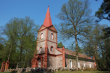 |
The church was built in 1835, and its greatest treasure is the organ, which was built by Karl Bittner in 1854. The manse is being restored. Boats are available for rental. |
|
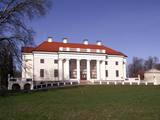 |
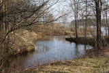
This landscape park has survived to the present day and was installed between 1850 and 1860. On one side the territory has a boundary that is the dammed Kruoja River, and on the other side there is a fence made of fieldstones. The English park principles at that time meant that advantage was given to a natural landscape with imitations of nature. There are some 26 types of trees in the park, and some of them were introduced from various parts of the world a few centuries ago. |
|
 |
Meklējams Virgas centrā. Asprātīgā piemiņas zīme (tēlnieks R. Gabaliņš, mākslinieks R. Kalniņš) – zābaks ar diviem pretēji vērstiem lielgabaliem un lodēm vēsta par Ziemeļu kara laika notikumiem, kad 1701. g. Virgā bija izveidota zviedru karaspēka nometne. Stāsta, ka karalis Kārlis XII savu zābaku pazaudējis citā reizē un vietā - Spilves kaujā pie Rīgas. |
|
 |
Stādaudzētava piedāvā rožu, skujeņu, dižstādu, ūdensaugu, lapu krūmu un dzīvžogu materiāla iegādi un konsultācijas.
|
|
 3 days
| ||
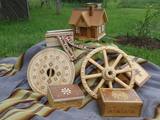 |
The workshop and “Dream Hut” exhibition hall at this venue offer a look at turned wood products such as candelabras, dishware, beer steins, vases, glasses, mortars and pestles, small boxes, wooden paintings, etc. You can commission and purchase products and watch the master at work. |
|
 |
Nordeķu - Kalnciema kāpu grēdas daļa Kleistu meža austrumdaļā pie Dzirciema ielas. Padomju laikā šeit darbojās divi (vēlāk viens) P - 35 radars, kas griezās ap savu asi. Vietējie iedzīvotāji tolaik šo vietu bija iesaukuši par "Lokatoru kalniņu". Ziemeļos no tā atradās padomju armijas cūku ferma. |
|
 |
Atrodas Plateļu centrā. Plateļi ir otra lielākā apdzīvotā vieta nacionālā parka teritorijā. Apmeklētāju centrā var noskaidrot aktuālo informāciju, pieteikties organizētās ekskursijās, iegādāties informatīvus materiālus, kā arī apskatīt nelielu dabas ekspozīciju par nozīmīgākajām parka dabas vērtībām. |
|
 |
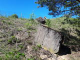
Ap 200m garš un līdz 15m augsts ainavisks atsegums upes labā krasta asā līkumā. Tam iepretim otrā krastā (500m) Līgatnes dabas takas.
|
|
 3 days
|
This tour will take you exploring the peculiar island of Rusnė and the delta of the river Nemunas in Lithuania. The island of Rusnė in the Nemunas Delta Regional Park is enclosed by waters of the river Nemunas and its tributaries. It is a resting place for migratory birds and home to a cormorant colony. The area of the island is 45 km2 and it is connected to the mainland by a bridge. The island of Rusnė is the lowest place in Lithuania, lying below sea level. The historic centre of the town Rusnė is characteristic of authentic wooden architecture, buildings painted in bright colours, colourful window shutters and decorations. The Baltic Coastal Hiking Route leads through the small town of Šilutė, revealing architecture that was once common to East Prussia. From Šilutė to Kintai, the Baltic Coastal Hiking Route runs along a low plain. To protect this area from flood waters of Nemunas, there is a system of dams, polders and canals established. After crossing the river Minija, the route invites you to visit the ethnographic village of Minija. Here you can enjoy the lowland landscape of the seaside region with vast wetlands and ponds. |
|
|
|
Der weiteste Nordpunkt der Insel Hiiumaa. Der höchste Leuchtturm Estlands aus Roheisen (1873 – 1875) und das Denkmal zur Errinerung an die bei dem Unglück des Schiffes ‘Estonia” Umgekommenen. |
|
 |
Folkloras taka "Jāņkalni" iepazīstina ar mūsu senču rakstiem, zīmēm un dievībām, kas ir mūsu folkloras mantojums. Folkloras takas (garums: apm. 1,5 km vai 2 stundas) mērķis ir arī iepazīstināšana ar senlatviešu ieražām, folkloru, kā arī tautu dainu izprašana. Piedāvā iziet Latvijas karti - labirintu ar 19 etnogrāfiskajiem novadiem. Gids Jums sniegs izsmeļošu stāstījumu un atbildes uz interesējošiem jautājumiem.
|
|
 |
To the south of Koknese, the Destiny Garden is on an island that is surrounded by the waters of the Pļaviņas hydroelectric power plant (there is a bridge to the shore). The aim of this fundamental open-air object was to commemorate people in Latvia who suffered because of totalitarian regimes. The first work here began in 2008, and the designer of the landscape was a Japanese landscape architect, Shunmyo Masuno. Work on the garden continues, but it is already a popular tourist destination. The first permanent structure is a terrace that offers a view of the Koknese castle ruins and the local Lutheran church. This means that there will be something new each time that people visit the park. People are invited to bring rocks for this nationally important location that commemorates Latvia’s history. |
|
 |
In the small town of Pļaviņas, at the place where the Skanstupīte River flows into the Daugava (Friendship Park), there are the remnants of a set of small and low fortifications known as the Swedish bastions. This was a place of military and political importance, because here was the place where the boundaries of Vidzeme (under Swedish rule), Latgale (under Polish rule), and the Duchy of Kurzeme (on the opposite side of the river) all came together. In 1625, the Swedes were defeated by the Poles here, and Swedish King Gustav Adolf almost lost his life. Medieval bastions of this kind can be seen in some other places of Latvia, as well.
|
|
 |
Here you can tour a local brewery, ride bikes, enjoy water sports, go fishing in the local river, and taste foods with hops. The guesthouse offers tastings of herbal teas and beer. Learn all about traditions in brewing beer. |
|
|
|
Cēsu centrālais laukums – Vienības laukums (20.gs.sākumā – Konventa laukums) – atgādina par Cēsu kauju notikumumiem, kuru nozīme un ikviena dalībnieka ieguldījums aprakstīti devīzē uz pieminekļa “No zobena saule lēca”. Cēsu kaujas 1019.gada jūnijā bija svarīgs Latvijas valstiskuma vēstures pagrieziena punkts, kad apvienotais latviešu un igauņu karaspēks sakāva vācu landesvēru, kas apdraudēja Baltijas valstu pastāvēšanu. Vienības laukums turpina būt par nozīmīgu notikumu liecinieku. 1989.gada 23.augustā daudzu cēsnieku ceļi veda uz Vienības laukumu, kuram cauri vijās Baltijas ceļš. |
|
 |
Innovative and delicious hemp and buckwheat products - tasty and good for the digestive system. |
|
 |
Vienu kilometru garā lokveida taka, kas ved pa lielāku nacionālā parka meža masīvu, uzskatāmi attēlo Žemaitijas augstienes un tuvākās apkārtnes reljefa veidošanās vēsturi. No takas augstākā punkta – Mikitai kalna, kas ir sens pagānu upurkalns, paveras (ainaviska stiga) tālākas apkārtnes skats. Kā takas interesantākie apskates objekti ir jāmin teikām apvītais akmens ar Velna pēdu un ar akmeņiem izliktas akas paliekas. |
|
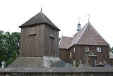 |
Iespaidīga koka celtne un izcils koka arhitektūras piemērs, kuru pamanīs katrs Plateļu apmeklētājs! Plateļu baznīca ir viens no Lietuvas vecākajiem koka dievnamiem. Pašreiz redzamais ir būvēts 1744. g., bet zvanu tornis – 1899. g. Dienvidos no baznīcas plešas Plateļu muižas parks. |
|
 |
One of the largest meat and dairy farms in Kurzeme, with a herd of around 500 heads of cattle. The farm also breeds most of the types of fowl that are known in Latvia. An informative tour is available, and you can purchase meat, milk and eggs. |
|


