
Природные объекты в Эстонии

Что особенного в природе в Эстонии?
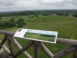
В Эстонии стоит самая впечатляющая каменная стена в Балтии - так называемый северо-эстонский «глинт» (от эстонского языка). У Эстонии есть своя «Земля островов» - регион Лахемаа с национальным парком, «Земля островов» - остров Сааремаа и архипелаг Монцунд. Залив Матсалу является одной из наиболее значительных остановок для отдыха птиц во время их миграции. В Эстонии есть один из самых заметных ударных кратеров в Европе, самые большие водопады и валуны в Балтии, холм Мунамаги - самая высокая точка в Балтии, Чудское озеро - 5-е по величине озеро в Европе, - с длинной Постоянные рыболовные традиции и великое разнообразие природы с запада на восток, с севера на юг.
Действуй ответственно - следуй Зеленому совету!
| Обзор | Подробности |
|---|---|
 |
Эстония
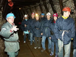
Gas mixtureGas mixture is the main raw material for Estonia’s energy and chemical industries, and it is extracted in our day from open quarries or underground shafts. This layer was established during the Ordovician Period between 450 and 480 million years ago, and it is made up of the remnants of plants and animals from that age. In the Kohtla-Nõmme suburb, there is a shaft which can be toured in the company of a guide who will tell you that this is the only layer of its kind in the Baltic States. He will tell you about how the gas mixture has been extracted over the course of history.
УслугиСервисы - отдых
Наблюдение за природойIn the village of Kiviõli, in turn, you can climb an old hill of slag from the gas mixture (Vana tuhamägi). This will open up a view of one of Estonia’s most interesting landscapes. For more information: www.kivioli.ee (available in English). |
 |
Эстония
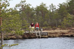
Erdi taka (Öördi rada)1,2 km gara taka, kas pa purvainu mežu aizved līdz Ērdi purvam (Öördi raba) un tā austrumu daļā esošajam Ērdi ezeram (Öördi järv), pie kura izveidota atpūtas un peldvieta. |
 |
Эстония
Skizentrum OtepääDas größte im Baltikum. Marathonloipe von Tartu, Wand der künstlichen Felsen und Trasse der Radmarathon. Skimuseum. Auf der Tehvandi-Sprungschanze ist ein Aussischtsplatform eingerichtet.  225 225
Услуги
225km - Расстояние от столицы |
 |
Эстония
Oksas (Oksa) takaBijušā piecstāvīgā metāla skatu torņa apkaimē plešas Lemmjegi upes palieņu pļavas. Netālu atrodas kādreizējā Oksas kroga (Oksa kõrts) vieta, kur saglabājies iespaidīgs manteļskurstenis. Apkaimes apskatei izveidota 0,8 km gara koka laipu taka. 175
Услуги
175km - Расстояние от столицы |
 |
Эстония
The Endla ReserveThis reserve was set up to protect local swamps and surrounding wetlands. Please note that before you can visit the reserve, you must register with the local administration and visitor centre in the village of Tooma.
УслугиСервисы - отдых
Природная тропаThe Endla swamp trail (~2 km) with a viewing tower, and the Endla stream trail (6 km). Please note that before you can visit the reserve, you must register with the local administration and visitor centre in the village of Tooma. For more information: www.endlakaitseala.ee (available in English). |
 |
Эстония
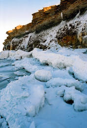
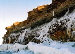
Pakri peninsulaAt the end of the Pakri peninsula is the most visually impressive shoreline cliff in the Baltic States – the Pakri cliff (Pakri pank), which is as much as 24 metres high. During cold winters, streams which flow from the layers of limestone cliffs form fantastic and unusual shapes of ice.
|
 |
Эстония
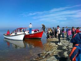
Туристическая фирма Heritage ToursПредприятие организует природные походы, целью которых является знакомство с природой (наблюдение за тюленями, пешие, велосипедные и лыжные природные походы, на резиновых лодках по островкам национального парка Вилсанди, вылазки к орхидеям и т. д.) и культурным наследием (мыза, сельская и городская жизнь, сегодняшний день Эстонского ремесла, морское наследие). В находящемся на территории национального парка Вилсанди лесном парке Мику можно познакомиться со старинными работами в лесу и даже поучаствовать в них. 200
 1-12 1-12
Услуги
200km - Расстояние от столицы
1-12 Месяцы активного сезона |
 |
Эстония
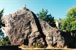
The Rock of Jana - TomaThe Rock of Jana - Toma is claiming itself to be the highest (almost 8 m) rock in The Baltic. It is located in Kasispea village. 72
Услуги
72km - Расстояние от столицы |
 |
Эстония
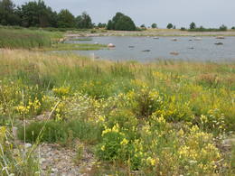
LuitemaaIn Estonian, Luitemaa means ‘the land of dunes’. It is the seashore territory of the Gulf of Pärnu, 13 km between Vöiste and Häädemeeste with shallow waters, vast coastal meadows, the highest dune range in Estonia and the Tolkuse Mire (Tolkuse raba). The Tolkuse mire trail (~2.2 km) and watching tower are available for dune and mire sightseeing tours. Situated in Luitemaa Nature Reserve. |
 |
Эстония
Halbinsel PärispeaAuf der Küste der Halbinsel befinden sich sowohl ehemalige Fischerdörfer, als auch die Reste eines Militärstützpunkts der Sowjetarmee. Großartige von den Gletschern des Eiszeitalters eingebrachte Feldsteine. 74
Услуги
74km - Расстояние от столицы |
 |
Эстония
Rannaje putnu verosanas tornis (Rannajõe linnutorn)Divstāvīgs skatu tornis pie Laikjula (Laiküla) – Hāpsalu ceļa, no kuras paveras plaša ainava uz Matsalu līcī ietekošo upīšu palieņu pļavām. Te var vērot migrējošās dzērves un zosis, bet pavasaros varbūt laimēsies redzēt vai dzirdēt ķikutu Gallinago media. Viens no retajiem torņiem, kas ir pielāgots cilvēkiem ar īpašām vajadzībām. |
 |
Эстония
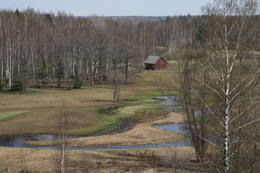
Mejekoses pargajienu taka (Meiekose matkarada)~ 3 – 5 km gara taka, kas ved pa veco ceļu gar Tēramā upes (Tõramaa jõgi) kreiso krastu. Takas malās izvietoti interaktīvi elementi bērniem, kas palīdz labāk uztvert dabā notiekošo. Taku ieskauj mitrie meži un palieņu pļavas, kas palu laikā atrodas zem ūdens. Tēramā (Tõramaa) ciemā apkārtnē atrastas cilvēka darbības pēdas jau no akmens laikmeta. 149
Услуги
149km - Расстояние от столицы |
 |
Эстония
Turisalu cliffThis cliff is made of sandstone (its lower part) and limestone (the upper part). It is up to 30 m high, and it is part of the Northern Estonian set of cliffs along the shore of the Bay of Finland. This is a popular tourism destination and viewing location. Recommended Hike along the bottom of the cliff (a rocky beach) in one direction, and then along the top of the cliff to get back (~2 km). From the top of the cliff, you can see a broad segment of the shoreline territory, all the way to Tallinn.
|
 |
Эстония
Torna kalns (Tornimägi)Karulas augstienes augstākais reljefa punkts (137 m.vjl.), kas virs tuvākās apkārtnes paceļas par ~ 60 m. Torņa kalnā ir uzbūvēts skatu tornis ar ļoti plašu apkārtskatu. Uz tā platformas ir novietoti panorāmas fotoattēli, kuros atzīmēti zīmīgākie plašākā apkaimē redzamie objekti – apdzīvotas vietas, pilskalni, baznīcu torņi u.c. Turpat izveidota atpūtas vieta un meklējams Rebases ainavu takas sākums. 260
Услуги
260km - Расстояние от столицы |
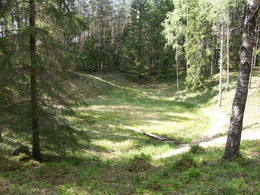 |
Эстония
The Ilumetsa meteor cratersThere are three craters here, and the biggest one, known locally as Põrguhaud, or Grave of Hell, has a diameter of 80 m and a depth of up to 12 m. There are barriers around the crater that are several metres high. The other two craters are hard to spot. The craters around 6,000 years old. No scraps of the supposed meteorite have been found, however, and so the origins of the craters cannot be confirmed with certainty.
УслугиСервисы - отдых
Природная тропаThe trail to the Põrguhaud crater is around 700 metres in length. For more information: http://www.ut.ee/BGGM/vaatamis/ilumetsa.html (only in Estonian). |
 |
Эстония
Skats uz Vaikas salam (Vaika saared)No Vilsandi bākas un tai tuvākās apkaimes ir labi saskatāmas leģendārās Vaikas salas. Tām ir piešķirts rezervāta statuss, tādēļ salas var apskatīt tikai no attāluma. Mazākā no saliņām - Kullipank ir tikai pārdesmit metrus diametrā. Tā ir jūras ūdeņu izrobots zemas un asas dolomīta klints fragments, kas klāts ar oļiem, nelieliem laukakmeņiem un kādu atsevišķi stāvošu lakstaugu. Domājams, ka vētru laikā tā pazūd zem jūras ūdens. Savukārt, Alumine Vaigas – Apakšējā Vaikas sala ir lielākā no sešām salām. Šīs salas diametrs ir ~ 150 m un tā paceļas vismaz kādus divus metrus virs jūras līmeņa. Uz salas ir bagātīga veģetācija un pat kāds zems krūms salas centrā. Redzami arī metru augsti atsegumi. Uz salas vēl joprojām atrodas 20. gs. sākumā celto „putnu māju” paliekas, kas bija domātas ligzdojošo putnu piesaistīšanai. |
|
|
Эстония
Lemmje pargajienu taka (Lemmjõe matkarada)Taka, kas izveidota Lemmjegi (Lemmjõgi) un Raudnas (Raudna jõgi) satekas vietā, iepazīstina ar palieņu pļavām un veciem pārmitriem mežiem, kas ir vieni no lielākajiem Igaunijā. Takas sākumā dominē atklātas lauku ainavas. Viens no 4,9 km garās lokveida takas apskates objektiem ir Lemjē dižozols. Mitrā laikā noderēs ūdensizturīgi apavi. 155
Услуги
155km - Расстояние от столицы |
 |
Эстония
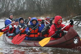
Туристический центр ЛахемааЦелью туристического центра Лахемаа является пропаганда природосберегающего образа жизни и умения жить в природе-сажаются деревья и развешиваются домики для птиц. Для интересующихся - походы на каноэ по Лахемааскому национальному парку, походы по болоту и стрельбу из лука и арбалета. Приятно провести время можно в каминном зале и сауне с гидромассажной ванной. 70
1-12
Услуги
70km - Расстояние от столицы
1-12 Месяцы активного сезона |
 |
Эстония
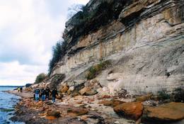
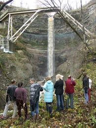
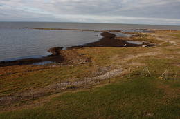
Saka-Ontika-Toila-pank (cliff)This is a cliff with various levels. Known as the North Estonian cliff, it stretches all along the shore of the Bay of Rīga in Estonia, including some of the local islands. The most expressive part in geological and landscape terms is the Saka-Ontika-Toila cliff, which is around 22 km long and offers an unusual natural environment. The cliff is as much as 53 m high, and it has a fairly virginal forest along its slopes. The layers of clay, sandstone, limestone, etc., come from the Cambrian and Ordovician periods. The Valaste juga (Valaste waterfall) is 24 metres high. After a longer period of freezing temperatures, the waterfall has a particularly impressive appearance. Seasonal waterfalls (8-10 m) can be found near the villages of Ontika and Toila.
УслугиСервисы - отдых
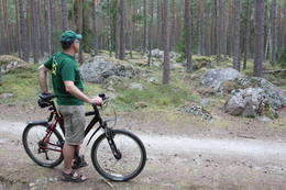
ВеломаршрутBike from Saka to Taoil (20 km) along the road that is at the top of the cliffs.
Природная тропаHike along the seashore during the season when trees are bare, moving from Saka to Toila (~22 km).
Наблюдение за природойThere is an impressive viewing platform at the Valaste waterfall. |
 |
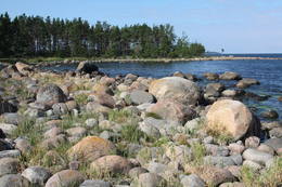
Эстония
Halbinsel KäsmuEine von Nadelbaumwäldern bedeckte Halbinsel. Malerisches Käsmu Steinfeld, Matsikivi Stein, Vana Jüri Stein u.a. Bei passenden Bedingungen kann man sich auf einer steinernen Landzunge bis zur 0,5 km entfernt liegenden Insel Saartneem schleppen. 81
Услуги
81km - Расстояние от столицы |
 |
Эстония
Saaremaa IslandThe biggest sea island in Estonia. In translation - "Land of The Islands". A bridge, where cyclists can drive connects Saaremaa island to Muhu island . 160
Услуги
160km - Расстояние от столицы |
 |
Эстония
Aegna IslandThis is an entirely forested island in the Bay of Finland, ~14 km from Tallinn. A network of small pathways covers the entire island. Recommended hike along the seashore of the island, which will offer dunes, as well as a coastline that is sandy in some parts, rocky in others, and covered with reeds in still others (~9 km). A ferry boat will take you to the island from the Pirita port.
|
 |
Эстония
Felsen PakriDie mächtigste Steilküste im Baltikum (bis zu 24 m hoch). In den kalten Winter werden hier phantastische Gletscherstürze entstanden. Pakri Leuchtturm. 50
Услуги
50km - Расстояние от столицы |
 |
Эстония
Приключенческая фирма 360 градусовКомпания занимается организацией природных походов: летом морские походы на байдарке, осенью на болотоступах по болоту, зимой походы на снегоступах и весной на каноэ по рекам. 37
1-12
Услуги
37km - Расстояние от столицы
1-12 Месяцы активного сезона |
 |
Эстония
Ehijervs (Ähijärv)Karulas nacionālā parka lielākais ezers - 2,8 km garš, līdz 1 km plats. Ezera ziemeļaustrumu krastā atrodas parka apmeklētāju centrs. 5,5 m dziļais ezers ir gan zivīm, gan nostāstiem bagāta vieta. Ezera un tuvākās apkārtnes iepazīšanas nolūkā ir izveidota 3,5 km garā Ehijerva taka (Ähijärve teerada). Tās sākums atrodas pie iepriekš minētā apmeklētāju centra, kur izveidota atpūtas vieta un atraktīvs bērnu spēļu laukums. Taka sākumā ved gar ezera krastu, nelieliem mitrājiem un meža ceļiem, kas izmantoti iepriekšējos gadsimtos. |
 |
Эстония
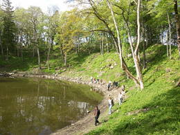
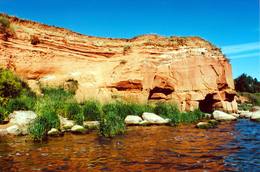
The sandstone cliffs of KallasteThis is one of the few places in the Baltic States where one can find Devonian period sandstone cliffs featuring abrasion caves, arches, etc. The cliffs are on the shores of Lake Peipsi (Peipsi järv), near Kallaste, and they are between two and four (in some cases – nine) metres high, stretching for a distance of around one km.
УслугиСервисы - отдых
Природная тропаHike along the shores of the lake to and from the cliffs (3 km).
Наблюдение за природойThere is a viewing tower which offers a good look at Lake Peipsi and the shoreline. For more information: www.kallaste.ee (only in Estonian). |
 |
Эстония
Putnu verosanas tornis Puises ragaPuises ragā (Puise nina) ir uzcelts divstāvīgs atpūtas nams, kas apvienots ar putnu vērošanas torni. No tā paveras skats uz piekrasti, kas ir iecienīta migrējošo zosu atpūtas vieta. Šī ir privāta teritorija, kuras apskati vēlams saskaņot ar īpašnieku. 123
Услуги
123km - Расстояние от столицы |
 |
Эстония
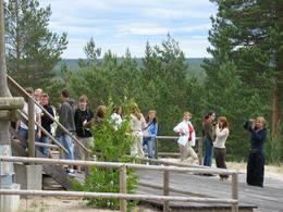
The Lahemaa National ParkThis is the first national park in Estonia and the Baltic States. Perfect for a day trip out from Tallinn for a hiking trip and nature watching. It was established in 1971 to protect the area that is along the Bay of Finland – the shoreline, forests, swamps, meadow biotopes, species, natural monuments, rocks, waterfalls, cliffs and cultural monuments such as ancient cemeteries, castle hills, baronial estates, fishing villages, etc. Услуги
50km - Расстояние от столицыСервисы - отдых
Беговая лыжняFor cross-country skiers, the Käsmu peninsula is perfect during the season.
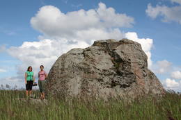
ВеломаршрутFor bikers, there’s the Käsmu peninsula (~10 km), the route Loksa-Pärispea-Viinistu-Kasispea on the Pärispea peninsula (here you will find the highest rock in the Baltic States – the Jaani-Tooma rock (kivi, 7.8 metres high).
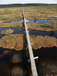
Природная тропаYou can hike a wooden train over the Viru swamp (Viru raba, 3.5 km), another trail on the Käsmu peninsula (~15 km), and the Pikanõmme-Majakivi trail (4.5 km), along which you will find the third largest rock in the Baltic States – the so-called House Rock (Majakivi), which has a size of 584 m3. We also suggest the informational Altja trail (3 km).
Наблюдение за природойThere are viewing towers in the Viru raba swamp and along the Piaknõmme-Majakivi trail. There is a visitor centre at Palmse. |
 |
Эстония
The Otepää Nature ParkThis park is found in the Otepää highlands and offers an outstanding example of how the terrain of a protected natural territory can be used for recreation, sports and active leisure. The infrastructure of the park is perfect for such activities and is of a high level of quality.
УслугиСервисы - отдых
Беговая лыжняDuring the winter, you can ski the 63-km Tartu marathon trail, which crosses the park.
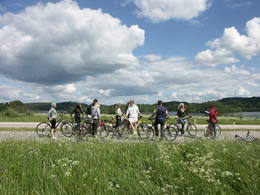
ВеломаршрутBike around Lake Pühajärv from the centre of Otepää (~20 km), or ride from Otepää to Kääriku (11 km).
Природная тропаHike around Lake Pühajärv (12 km), hike the Kekkose hiking route (14 km), or hike the Murrumetsa hiking trail (3.5 km). Bike around Lake Pühajärv from the centre of Otepää (~20 km), or ride from Otepää to Kääriku (11 km).
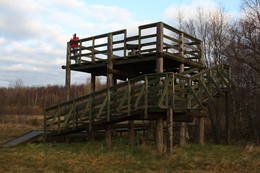
Наблюдение за природойThere are viewing towers at Harimägi and in the hills of Kuutsemägi, near the Otepää ski jump, at Väike Munamägi, and near the Otepää castle hill. For more information: www.otepaaloodus.ee (available in English). |
 |
Эстония
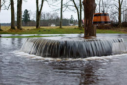
Ландшафтный заказник Тухала и Ведьмин колодецМестность Тухала была заселена почти 3000 лет назад. Здесь 11 древних поселений, 30 культовых камней, 3 каменных могильника, 4 культовые рощи и т. д. В ландшафтном заказнике Тухала располагается и уникальный Ведьмин колодец, который во время большой воды «кипит», выливая 100 литров воды в секунду, а также 5 мощнейших энергетических столбов в Эстонии. 32
1-12
Услуги
32km - Расстояние от столицы
1-12 Месяцы активного сезона |


