
| Нo | Название | Описание |
|---|---|---|
 |
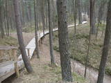
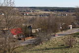
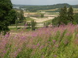
Ap 9 km garā taka (vienā virzienā) sākas Skaņākalna dabas parkā (Mazsalacā) un beidzas pie Ramatas. Tā iepazīstina ar Salacas ielejas dabas parka nozīmīgākajām vērtībām – smilšakmens atsegumiem (Skaņaiskalns, Dauģēnu klintis u.c.), alām, nozīmīgu izmēru laukakmeņiem u.c. Taka marķēta. Tajā izvietoti informācijas stendi, norādes. Jāpadomā par loģistiku – kā nokļūt sākuma punktā. |
|
|
|
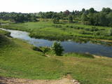
The mouth of the most beautiful river of Vidzeme. On the seashore between the mouths of River Gauja and River Daugava, one of the largest dune ranges in Latvia with distinctive parabolic dunes overgrown with forest (wooded dunes) is situated. The Mouth of River Gauja is unique as it is one of the few major rivers in Latvia and in EU countries to flow into the sea naturally. There is no harbour or other hydro-engineering construction. It is a popular recreation area in the vicinity of Riga and Saulkrasti while, unfortunately, the lack of infrastructure makes it suffer from anthropogenic load. Not far from the rivermouth, hidden in dunes, there are pillboxes which were built in 1920 or 30ies as anti-airborne barriers. There was a whole range of them along the coastline from the mouth of the River Lielupe to the mouth of the River Gauja forming a part of the Daugavgrīva Fortress fortifications. The pillbox is made of concrete, ca 1.5m thick. Every year, on the 3rd Sunday in August, a lamprey festival takes place in Carnikava town by the Gauja rivermouth. Carnikava is called the Lamprey Capital as it is famous for its lamprey fishing tradition and generous catches. The Mouth of the River Gauja is a good bird-watching area, especially in spring and autumn when one can observe the highest variety of species. Just few of the many bird species that can be observed near the Gauja rivermouth |
|
 |
The nature park in the city of Jūrmala was set up to protect dune, pine forest and shoreline habitats. This park features one of the most attractive nature trails in the Rīga area, and it is found near the famous Ragakāpa dune, which can be as much as 17 metres high. This is an excellent opportunity to study dune habitats and the plants, birds, insects, etc., which live there. Visitors can also see pine trees that are 100 years old and older. |
|
 |
The park was established to protect the Venta River valley and the landscapes that are around its tributaries. On the west bank of the Venta, at Papilė, there is a cliff from the Jurassic period which is unique in the Baltic States, has been known since 1925, and has layers in which more than 300 forms of life have been identified over the course of time.
|
|
 |
The nature park in the Daugava River valley is the only place between the cascades of the Daugava hydroelectric power plants there is still a chance to see the Daugava River valley and the ravines of its tributaries as they appeared before the area was flooded so that the power plants could be constructed. Particularly lovely views are found on the right bank of the river near the Aizkraukle church and castle hill. Forests, meadows, origins of streams and small dolomite cliffs in this area are all protected biotopes. Leisure facilities have been installed on the Aizkraukle castle hill, and the Aizkraukle castle ruins are not far away. |
|
 |
The most important aspects of this park are a shallow lagoon-type lake – Lake Pape, with its flood land meadows, the shore of the Baltic Sea, the Nida swamp, and the more than 270 different types of birds that have been spotted here. The oldest bird ringing station in Latvia (est. 1966) is found between Lake Pape and the Baltic Sea. Birds and bats are caught and ringed there. Lake Pape is the first place in Latvia where so-called “wild” horses (the “Konik” breed) were released with the aim of managing the flood land meadows.
|
|
 |
The Bauska Nature Park runs for several dozen kilometres along the Lielupe River and its tributaries – the Mūsa and the Mēmele. This is a protected territory. The shores of these rivers contain some of the largest dolomite cliffs in Zemgale. These are protected both as biotopes and as geological monuments. The rivers are important places for river lampreys and vimbas to spawn. Tourists will be attracted by the cultural landscape of the area, as well as the cultural monuments such as the Bauska castle, the Jumpravmuiža park, the Mežotne castle hill, Vīna Hill, the Mežotne castle, etc. The rivers are used for water tourism. |
|
 |
This territory in the northern part of the Dzūkija Highlands with lots of hillocks and lakes. The most interesting tourist destination is Velnio duobė (Devil’s Flowerbed) – a funnel-shaped hole that is up to 40 m deep and 200 m wide and is thought to have originated during the Ice Age.
|
|
 |
Городище Бусе (Маткулес) находится в изгибе берегов реки Имула. С него, на противоположный берег Имулы открывается один из самых живописных видов на речушки Курземе. Видом лучше всего любоваться в безлистный период, когда ландшафт не закрывает береговая растительность. С правого берега великолепный вид на долину Имулы открывается также по дороге к городищу рядом с домом Бусе. |
|
 |
This is one of the highest points among the hillocks of the Selonian area of Zemgale – Borīškalns Hill. From the tower, you will see Lake Sauka, as well as the forests and farmland which surround it. The “Kalna Ļūdāni” farm is nearby, and its owner uses his livestock to help to maintain the surrounding landscape.
|
|
 |
Ārkārtīgi ainaviska teritorija Augšzemes augstienes centrālajā daļā ar vairākiem ezeriem - Medumu, Lielo un Mazo Ilgas, Šķirsteņu un dažām mazākām ūdenstilpēm. Medumu ezera salām ir dabas lieguma statuss. Teritoriju šķērso vairāki grantēti ceļi, no kuriem dažviet paveras brīnišķīgas, bet nelabiekārtotas skatu vietas. Teritorijā atrodas Medumu katoļu baznīca. Piemērota teritorija dažādu aktīvā tūrisma veidu attīstībai. Dabas parks ietilpst Augšzemes aizsargājamo ainavu apvidū. |
|
 |
The “backbone” to this park is the valley of the Šventoji (Holy) River. One of the most impressive Devonian cliffs in Lithuania can be seen from the river – Vetygalos atodanga. On the shores of the Varius stream is a cliff made of quartz and sand – Variaus atodanga. 6 km to the S of Anykščiai is Lithuania’s second largest rock (5.7 m high, ~100 m3) – Puntukas akmuo.
|
|
 |
This park is in a region of hillocks in the Karula highlands, and Lake Ähijärve is at its centre. The park offers a cultural environment of small farms, and it was set up to protect the unique cupola-shaped hillocks of the area. Main attractions: Scenic Lake Ähijärv (176ha), Rebasemõisa Tornimägi hill (137.8 m above sea level), undulating landscapes. |
|
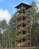 |
Atrodas Numerenes dabas parka teritorijā. 20 m augstais tornis uzbūvēts uz t.s. Numerenes vaļņa, no kura paveras plaša ainava un aizaugošām lauksaimniecības zemēm un nelielu mitrāju ar Kugreņa ezeru austrumu virzienā. Torņa apkaimē izveidota izziņas taka. |
|
 |
We recommend that you walk through the town of Kandava not only to enjoy the charm of a small town, but also to find fantastic viewing locations where you can see the town and the shores of the ancient Abava River valley from the Kurši (Ancestor) castle hill, Lielā Street, the Bruņinieki castle hill and Zīļu Street (School Hill), as well as from the area of the Ozolāji open-air stage.
|
|
 |
This territory was established to protect the lovely central section of the Neries River, local species, and Lithuania’s largest oak forest.
|
|
 |
An important complex of the coastline and its sand dunes along with the mouths of three major rivers – the Lielupe, the Daugava and the Gauja. This area has ancient traditions of recreation and spa services. The territory has lovely shoreline landscapes and features one of the few coastline meadows in Latvia. The nature park includes several restricted areas – the meadows of the Lielupe estuary, Vakarbuļļi, Daugavgrīva, Vecdaugava and Ummis (see the section on “Restricted Natural Areas”). Interesting elements of nature in this area include the amphitheatre of the Garciems dunes, along with individual dunes such as the Legzdiņi dune and the so-called ski mountain dune. Visitors will be attracted by various cultural and historical monuments – fortifications on the Mangaļi peninsula, military buildings from the period of the Russian tsars all the way through the late period of the Soviet occupation, the fortress of Daugavgrīva, the Vecāķi spa with its old shoreline buildings, and the beaches at Daugavgrīva and Vecāķi. The proximity of the city of Rīga and various important recreational resources are the reason for the massive anthropogenic burden that is placed on this territory. The nature park is appropriate for active tourism (hiking, bicycling, boating, driving), distance skiing, nature and bird-watching, cultural tourism, passive leisure and educational tourism. There are nature trails at Daugavgrīva and the Rožu dunes, along with other elements of infrastructure. |
|
 |
This park was established to protect Lithuania’s longest lake, Lake Asveja (> 20 km). The lake is in a sub-glacial valley carved out by ice during the Ice Age, and it actually resembles a wide and curvy river.
|
|
 |
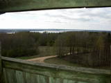
Latvia’s highest hill is the second highest in the Baltic States, but alas, it has only a wrecked viewing tower, so you’ll have to look for the best views on your own. You’ll find some around the tower and the ski trails, particularly Large and Small Golgotha. It is worth hiking the Gaiziņkalns nature trail.
|
|
 |
Находится на левом берегу Лиелупе, напротив Межотненского замка. Одно из крупнейших укрепленных городищ земгалов 9 - 13 вв., рядом с которым на площади в 13 га располагался древний город. Благоустроено. Через Лиелупе построен понтонный мост, по которому пешеходы и велосипедисты (май - октябрь) могут пройти к Межотненскому замку. Примерно в 0,5 км к югу от городища находится Винная гора, до которой ведут деревянные мостки. |
|


