
| Нo | Название | Описание |
|---|---|---|
|
|
Meklējams pie Gulbjiem – Dvietes senlejas informācijas centra. No torņa labi pārskatāma ūdeņiem bagātos pavasaros pārplūstošā Dvietes paliene, dzīvei savvaļā pielāgoto mājlopu aploki un izlīkumotā Dvietes upīte. |
|
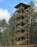 |
Atrodas Numerenes dabas parka teritorijā. 20 m augstais tornis uzbūvēts uz t.s. Numerenes vaļņa, no kura paveras plaša ainava un aizaugošām lauksaimniecības zemēm un nelielu mitrāju ar Kugreņa ezeru austrumu virzienā. Torņa apkaimē izveidota izziņas taka. |
|
|
|
Atrodas uz nelielās Mīlestības saliņas, ko ieskauj Buļļupes un Daugavas ūdeņi. Saliņa sasniedzama tikai ar laivu. No torņa labi pārskatāma Daugava, Daugavas vārti (ieteka jūrā), Bolderājas, Mangaļsalas un Ziemeļblāzmas apkaime, kā arī apkaimes mitrāji (niedru audzes, ūdeņi). |
|
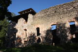 |
The ruins of the Rauna castle (which was built in 1262 and was a main residence of the Livonian archbishop) have a modern viewing tower which offers a view of the impressive castle walls, the place where the former Medieval city was located, and the centre of Rauna. The local government office has the keys to the tower.
|
|
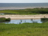 |
After a big storm in 2005, the nature trail of the Randu meadows was restored. It is about 4 km long, and there is a bird-watching tower which offers a fine view of unique shoreline meadows with small lagoons and areas of reeds. It is a fine place to watch migrating birds. This is part of the Northern Vidzeme Biosphere Reserve (ZBR).
|
|
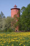 |
Второй из старейших в Латвии (1849 – 1850 гг.), самый высокий (82 мнад уровнем моря, 32-метровая башня)и дальше всех стоящий на суше (5 кмот моря) построенный маяк. Его огни выключены в 1999 г., и в наше время маяк служит смотровой вышкой и выставочным залом (в настоящее время – экспозиция, посвященная маякам Латвии и истории становления Балтийского моря). В ясную погоду с маяка хорошо виден Ирбенский пролив и мыс Сырве (остров Сааремаа) с маяком Сырве. Рядом с маяком находится Слитерская природная тропа, по которой (планируется в 2013 году) можно следовать только в сопровождении гида национального парка. Тропа находится в природном заповеднике, где в 1923 г. основан Слитерский памятник природы. Посетители могут увидеть Слитерские Синие горы – крутой обрывистый берег ледяного Балтийского озера, склоновые и широколиственные леса, ключи, известковое травяное болото, а также остатки канав старинной мелиорации и сгнившие еловые стволы, которые свалил ветер во время урагана 1969 года. Длина тропы 1,2 км. |
|
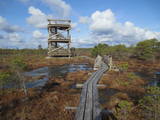 |
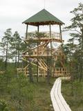
Atrodas 3,7 km garās laipu takas vidusdaļā. No torņa paveras viena no Latvijas izcilākajām augstā purva ezeriņu un lāmu kompleksa ainava. Tornis ir populāra saullēktu un ziemeļblāzmas fotografēšanas vieta. |
|
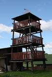 |
This is an interesting viewing tower which is part of one of the farm buildings. It offers a lovely view of the surrounding area.
|
|
 |
Construction on the lighthouse was initially completed in 1879. The structure suffered damage during both world wars and was restored several times. The structure is 19 metres high and stands 46.5 metres above the wavy sea. Here you will find one of the loveliest views of the shores of the Baltic Sea.
|
|
|
|
The viewing tower is on the western part of the Blue Hills of Ogre, not far from the Dubkalni quarry. Paths lead to the tower, as does a wooden staircase. The viewing platform offers a very broad view of the Ķegums hydroelectric power plant reservoir and the towers of
|
|
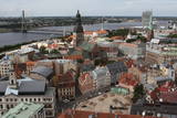 |
St Peter’s is one of the oldest historical monuments in the Baltic States, and it is also the best place from which to survey the historical centre of Rīga, which is part of the UNESCO list of world cultural heritage. You can see the central part of Old Rīga, City Hall Square, the Pārdaugava region on the opposite side of the river, and even – during clear weather – the Bay of Rīga. The tower of the church is 123 metres high, but the viewing location is at a height of 72 metres.
|
|
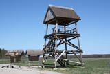 |
This barrow is on the western side of the Dunduri meadows and was built on the parking lot of the former collective farm. From the second level of the tower, you will have an excellent view of the meadows all the way to the Džukste River and the Kauguri canal. There are livestock accustomed to life in the wild, although they will sometimes be quite distant. This is a bird-watching location from the springtime until the second half of the summer. |
|
 |
This is part of a hiking trail along the Cena bog. It is on the western side of the bog, at the centre of the 5-kilometre circular trail. You can see the vast swamp, as well as a military road that was installed during World War I and is marked by an “alley” of large pine trees. Alongside the tower is a fragment of the road that was installed more recently.
|
|
 |
This is the highest church tower in Latvia, and from it you can see views of the Alūksne highlands. The view to the South is particularly impressive.
|
|
|
|
Atrodas Liepājā, E. Tisē un Lauku ielas krustojuma galā. Pa Ezera laipu (Liepājas ezera palieņu pļavas) var nokļūt līdz putnu vērošanas tornim, no kura labi pārlūkojama ezera ziemeļdaļa. Laba putnu vērošanas vieta. Ietilpst Liepājas ezera dabas lieguma teritorijā. |
|
|
|
33,5 m augstais tornis tikai nedaudz paceļas virs priežu galotnēm. Tas meklējams Dzintaru mežaparkā, kas ir ģimenēm ar bērniem draudzīga vieta. No torņa redzami Jūrmalas meži, augstākās ēkas (sanatorijas, viesnīcas) un Rīgas jūras līča ūdeņi. |
|
