
| Нo | Название | Описание |
|---|---|---|
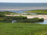 |
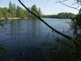
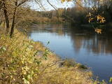
Айнажи – Салацгрива – важная территория для охраны рифов. Расположена напротив Салацгривского края, ее площадь составляет 7239 га.
|
|
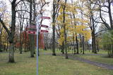 |
Viens no lielākajiem cilvēka veidotajiem Latvijasparkiem (70 ha), kas izstiepies no Liepājas ostas līdz Dienvidu fortam > 3 km garumā. Tā izveidi uzsāka jau 1870. g. pēc pilsētas mēra K. Ūliha iniciatīvas, uzbūvējot kūrmāju un strūklaku. 19. - 20. gs. mijā ap Dzintaru un Liepu ielām parādījās greznu villu un savrupmāju apbūve. Viena no skaistākajām ir jūgendstilā celtā savrupmāja Liepu ielā 27, kurā atrodas Krievijas ģenerālkonsultāts. Ēkai ir slēgta uzeja, balkoni, pildrežģa konstrukcijas un kārniņu jumts (arhitekti G. Jenike un P. M. Berči). Jūrmalas parks visās sezonās ir iecienīta pastaigu un dažādu aktivitāšu norises vieta. Te meklējams stadions „Daugava”, tenisa korti, koncertestrāde “Pūt, vējiņi!”, vasaras kafejnīcas, minigolfa laukums, bērnu rotaļu laukums, skeitparks. Šeit meklējamas lielākās Latvijas bungas – vides dizaina objekts. |
|
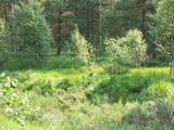 |
The word grīnis in Latvian refers to a very unusual type of forest – pine trees growing on sandy soil. There are two types of this environment – the heather type and the grass type. This is the result of long-lasting interaction between nature and humankind, and such sites are found in just a few places along the shores of the Baltic Sea in Latvia. A very rare plant which grows in the area – cross-leaved heath – was the main reason why a nature reserve was established here in 1936. An abandoned former rail line between Ventspils and Liepāja crosses the reserve from the North to the South. Visits to the reserve are strictly prohibited. |
|
 |
Riežupes dabas parks veidots g.k. Riežupes izteksmīgās ielejas, tai raksturīgo dabas vērtību – nogāžu un gravu mežu, dažādu ģeoloģisku dabas pieminekļu - smilšakmens atsegumu, alu, ūdenkritumu, upes straujteču posmu, dažādu sugu, mežu masīvu un ainavas aizsardzībai. Parka atrodas viens no Kurzemes populārākajiem tūrisma objektiem – Riežupes alas - garākais mākslīgo alu labirints Latvijā, kura eju kopgarums ir 460 m. Sākotnēji dabas veidotās alas 19. gs. vidū mākslīgi paplašināja baltās smilts ieguves nolūkos, kuras izmantoja stikla ražošanai. Parkā izveidots velotūrisma maršruts. |
|
 |
Охраняемая морская территория Нида – Перконе является одной из биологически многообразных и важных с точки зрения охраны природы морских территорий на побережье открытой части Балтийского моря – здесь находятся выдающиеся территории рифов. В период миграции территорию пересекает большинство мигрирующих пород птиц, встречающихся в Латвии. Расположенная напротив Руцавского и Ницского края территория площадью 36 703 га особенно важна для защиты большого крохаля и малой чайки. Территория частично перекрывается морской частью природного парка «Папе» и включает морскую часть территории природного парка «Бернаты».
|
|
 |
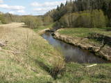
The Bauska Nature Park runs for several dozen kilometres along the Lielupe River and its tributaries – the Mūsa and the Mēmele. This is a protected territory. The shores of these rivers contain some of the largest dolomite cliffs in Zemgale. These are protected both as biotopes and as geological monuments. The rivers are important places for river lampreys and vimbas to spawn. Tourists will be attracted by the cultural landscape of the area, as well as the cultural monuments such as the Bauska castle, the Jumpravmuiža park, the Mežotne castle hill, Vīna Hill, the Mežotne castle, etc. The rivers are used for water tourism. |
|
 |
The ancient Abava River Valley between Kandava and the place where the river flows into the Venta River is the most expressive river valley segment in Kurzeme in terms of landscape and terrain. The valley is 30 to 40 metres deep and as much as 300 metres wide. The territory is distinguished by great diversity of a biological nature (more than 800 kinds of plants), featuring many different biotopes and natural monuments such as streams, waterfalls, cliffs, huge rocks, and many cultural and historical monumentssmall towns such as Kandava and Sabile. In both cases, the town centres are national monuments of urban construction. Popular tourist destinations include Vīnakalns hill in Sabile, where wine-making grapes are grown, as well as the open-air art museum at Pedvāle. To protect cultural treasures, a cultural and historical territory, “Abava River Valley” has been established. Wild livestock live at Drubazas and Tēvkalni to “maintain” the landscape. There are nature trails for tourists, and the Abava is the most popular river for water tourists in Kurzeme. Information is available at the tourist information centres in Kandava and Sabile. such as castle hills, churches, ancient burial grounds, and
|
|
 |
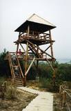
This lovely territory includes the hillocks of Embūte, which are in the ancient Embūte valley. The aim of establishing the park was to protect the landscape, biotopes and species of the region. An ecological tourism trail has been established in the valley, as has a forest trail through the nature park (accessibly only in the company of a guide). Visitors will learn about the hillocks and ravines left behind by the Ice Age. The ravines and the forests along their sides are protected biotopes. There are also important natural and cultural monuments, including the Embūte castle hill and the ruins of a baronial estate, castle and church. Other points of interest include the death place of the Courlandian warrior Indulis, the Joda dam, meadows, a viewing tower, etc. Three unmarked bicycle trails are in the area. |
|
 |
Dabas parks, kura lielāko daļu aizņem neprastās formas un līčiem bagātais Cārmaņa (arī Cārmins) ezers. Ezera ūdens ir ļoti tīrs, tādēļ tajā sastopamas Latvijai retas augu sabiedrības. Tā kā parka teritorijā nav tūristiem veidota infrastruktūra, interesenti var baudīt skatus, kas paveras uz ezera un tā apkārtni no Aulejas – Grāveru ceļa.
|
|
 |
Западное побережье Рижского залива – важное место пристанища и питания большого количества мигрирующих пород птиц на протяжении года. Наиболее встречаемые виды птиц - краснозобая и чернозобая гагара, юрмальская большая утка, морянка, темная утка и малая чайка. Территория находится напротив Дундагского, Ройского и Энгурского края, а также города Юрмалы, площадь – 132 173 га. Территория включает морскую часть природного парка «Энгуре» и Кемерского национального парка.
|
|
 |
This is a lovely place in Sigulda which has been painted (as the word "gleznotāji", which means "painters" suggests) and photographed for centuries. This is basically not a hill at all, it's just the place where the shore of the ancient Gauja River valley is split by the mighty Vējupīte ravine. You will have an excellent view of the Turaida Castle and the river valley. There are leisure facilities and a viewing platform there. You can ride to Paradīze hill via an electric car. |
|
 |
Salīdzinoši liela un cilvēka mazskarta teritorija ziemeļos no Lubāna ezera, kas izceļas ar lielu purvu un mitro mežu, kā arī tajā dzīvojošo organismu daudzveidību. Cauri teritorijas austrumu daļai tek Aiviekste. Dabas liegums ir grūti pieejams, tajā nav izveidota ar tūrismu saistīta infrastruktūra, tādēl vislabākais veids ir to aplūkot no Lubānas - Gaigalavas ceļa, kā arī putnu vērošanas torņa pie Gomeļa ezera (Gūmelis), kurš gan 2007. g. rudenī bija cietis no apmeklētāju vandālisma. Teritorija ietilpst Lubāna mitrāja kompleksā.
|
|
 |
This is Latvia’s oldest nature reserve and, indeed, the country’s oldest protected natural territory. Moricsala is an island in Lake Usma, which is the fifth largest lake in Latvia. The reserve was established in 1912 at the initiative of a group of nature students from Rīga. They wished to protect the deciduous forest of oak trees on the island, along with the local flora and fauna. The nature reserve also includes the Lielalksnīte island. Visits to the reserve, however, are strictly prohibited. |
|
 |
Teritorija, kas aptuveni 20 km garumā „piekļāvusies” abiem Aiviekstes upes krastiem. Dabas parka galvenā vērtība ir palieņu pļavas (un citi pļavu biotopi), kas ir ļoti nozīmīga daudzu augu un dzīvnieku (īpaši – putnu) sugu dzīves vieta. Ūdenstūristiem, kas laivo pa Aivieksti, nakšņošana ir jāplāno tikai šim mērķim paredzētās vietās!
|
|
 |
Слитерский национальный парк (как заповедник основан в 1923 г., как национальный парк 2000 г.) не без основания называют музеем под открытым небом предшествующей стадии развития Балтийского моря. Современными «живыми» свидетелями тех геологических событий являются Слитерские Голубые холмы - крутые, высотой до 20 – 30 м, образовавшиеся со времен Балтийского ледового озера (стадия Балтийского моря до 10 000 лет назад), холмы Стиебру – древний берег Анцилового озера (8 – 9 тысяч лет тому назад), наибольший в Европе по площади ландшафт валообразных дюн (кангари) и заболоченных междюновых впадин (виги), которые являются образованиями времен Литоринского озера (4 – 7 тысяч лет тому назад). Мягкий климат Северного Курземе служит причиной тому, что здесь наблюдается многообразие пород растений (около 860 пород) и встречается очень много редких для Латвии растений (напр., тис обыкновенный и плющ балтийский). Своего рода заслуга в сохранении здешних природных богатств принадлежит и советскому военному режиму, существовавшему когда-то на морском побережье, и из-за которого на протяжении полувека побережье оставалось почти нетронутым с точки зрения посещения и строительства. Свидетелями того времени остаются покинутые базы и разные военные объекты армии СССР. В Слитерском национальном парке находится один из популярнейших объектов туризма Латвии - Колкский мыс, который в течение года посещают более 50 000 путешествующих, а во время весенней миграции через мыс в течение часа проносятся десятки тысяч птиц. На участке берега Балтийского моря – т.е. на Либиешском берегу от Колки до Сикрага и Овиши сохранились рыбацкие поселки ливов (одна из малочисленных народностей мира) и прочие свидетельства их культуры. К услугам туристов четыре природных тропы, веломаршруты, наблюдательная вышка, открыт для посещения Шлитерский маяк.
|
|
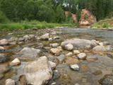 |
Амата является одной из самых быстроводных рек Латвии, поэтому каждую весну здесь собираются любители водного туризма – ценители спортивных мероприятий и любители острых ощущений! Вниз по течению, вдоль автомобильной дороги Рига – Вецлайцене, Амата впадает в глубокое русло, где ее среднее падение превышает 3 м/км, достигая даже 8 - 10 м/км. Русло Аматы изобилует обнажениями пород песчаника и доломита, которые называются утесами, самые знаменитые из них - это утес Визулю (здесь может образовываться красивый ледопад), обрыв Айнаву, утес Каубью, Дзилнас, Звартес и Лустузис. От Мелтури до моста Вецлаучу вдоль правого берега имеется маркировка (оранжевые точки на деревьях) т.н. Аматская геологическая тропа. У тропы есть три части: Мелтури – рыбное хозяйство Карлю, рыбное хозяйство Карлю – утес Звартес, утес Звартес – мост Вецлаучу. В поход по тропе можно отправиться в любое время года, за исключением – в зиму, когда глубокий снег. Самые впечатляющие виды открываются поздней осенью, когда нет листвы. |
|
 |
The Kaļķupe River valley was established as the Pilsupe River (formed by Kaļķupe River and Mazupe River) crossed the Blue hills of Šlītere to the South of Vīdale and Kaļķi. The distinct river valley has a branched network of gullies in which Devonian sandstone has been uncovered and can be seen in some locations. Puiškalns Hill (located at confluence of Kaļķupe River and Mazupe River), which was used as a castle hill and as a sacred location long in the past, is one of the most distinctive parts of the area. It is a popular tourist destination in the Talsi District. Hillside forests, various kinds of meadows and a wide range of plants are also of value in the local environment. |
|
 |
This territory is meant to protect the large hillocks and lakes of the Augšzeme highlands – Lake Svente, Lake Medums, Lake Ilga and others, with their islands, landscapes and species. The nature park which has been established around Lake Svente and Lake Medums is part of this territory, and there are several areas that are restricted for environmental reasons – Lake Bardinskis, Lake Skujine, and the islands of Lake Medums and Lake Svente. There is a viewing tower on Egļukalns Hill, along with downhill ski routes. |
|
 |
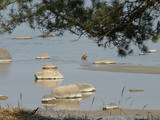
This territory protects the shore of the onetime Baltic lake of ice, which most significant part stretches for 10 kilometres on the eastern side of the Grobiņa-Ventspils highway from Kapsēde till Vērgale bus stop. From the top of this ancient shoreline there is a lovely view of the Piejūra lowlands, but no specific viewing areas or information stands have been installed. There are protected species and habitats in the territory. |
|
 |
Место, где можно отправиться на короткие и продолжительные прогулки. Здесь создана «Тропа Спридитиса» (с деревянными скульптурами героев сказки Анны Бригадере), протяженностью 1,6 км, «Учебная тропа лесных пейзажей», протяженностью 3,8 км и 8-ми км (в одном направлении) «Тропа пейзажей Аугшземе». Тропы расположены в субгляциальной ложбине, сформировавшейся от таяния ледника, где друг за другом разместились соединенные протоками несколько озерков и болотцев. В целях охраны пейзажей и других ценностей создан природный заповедник. В начале троп (недалеко от Пилскалне) стоит 30-метровый Мелнайскалнс (городище Рамава).
|
|
