
| Нo | Название | Описание |
|---|---|---|
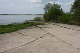 |
The hydroplane airfield is on the eastern shore of Lake Durbe, not far from Līguti. It was built between 1939 and 1941. During the Soviet era, the 43rd aviation escadrille was located here, and it had 13 MBR-2 hydroplanes. All that’s left today are the cement sheets on the shore of the lake. You can look at the site itself.
|
|
 |
Старые торфяные карьеры –
следующее место за Кемери, где гораздо в
больших количествах (г.о., во время первой
независимости Латвии) добывался торф.
|
|
 |
Lietuvas lielākais sūnu purvs, kura aizsardzības nolūkā ir izveidots Čepkeļu dabas rezervāts (Čepeklių gmatinis rezervatas). Tas izvietojies starp Dzūkijas nacionālā parka dienvidaustrumu daļu un Baltkrieviju. No Marcinkones pa smilšainu meža ceļu (~ 9 km turp - atpakaļ) ar kājām vai divriteni (arī nelielu tūrisma autobusu līdz 20 vietām) var nokļūt līdz purva malai, kur mežainās kāpās un purvā izveidota 1,5 km gara dabas taka un skatu tornis, no kura labi pārredzama purva rietumdaļa. Pirms došanās uz Čepkeļu purvu, ir jāreģistrējas Dzūkijas nacionālā parka apmeklētāju centrā (Šilagėlių gatve 11), kas meklējams aiz dzelzceļa pārbrauktuves. Te apskatāma neliela nacionālajam parkam un rezervātam veltīta ekspozīcija. |
|
 |
Oranžērija Bekuciems ir ģimeniska svinību vieta 40 min braucienu attālumā no Rīgas, Tomes pagasta Bekuciemā. Šeit ir iespējams svinēt savus dzīves skaistākos notikumus - kāzas, krustabas, dzimšanas dienas, bērniņa raudzības, fotosesijas, atpūsties pie dabas, gatavot ēst un pašiem saklāt skaistu svētku galdu, organizēt korporatīvos pasākumus, iepazīstināt ārzemju tūristu grupas ar latviešu tautas tradīcijām un dzīvesveidu. Oranžērija ir apsildāma un darbojas visu gadu. Tās platība ir 4x6m un tajā ērti var justies nelielas kompānijas līdz 15 personām. Tā ir pilnībā aprīkota ar visu nepieciešamo atpūtai - mēbelēm, traukiem, galda piederumiem, kafijas aparātu un tējkannu, bezvadu bluetooth skaļruni, ledusskapi, plediem, svečturiem, svecēm, vāzēm, bērnu barošanas krēsliņi utt. Ap oranžēriju ir plaša teritorija, kurā var atpūsties liels skaits cilvēku. Te irpļavas, dīķis, āras atpūtas vieta, pirts un pirts nojume, grils, kūpinātava, ugunskura vieta un ugunskura zupas vieta, pļavas altāris, bērnu spēļu laukums, pļavas futbols, āras labierīcības. Blakus ir sēņošanas un pastaigu vietas Bekuciema slavenajos mežos. No saimnieces vasaras sezonā var sarunāt zaļumus, garšaugus un zāļu tēju. |
|
 |
"Dobele Agra S.I.A." ir moderns, nākotnes perspektīvā domājošs lauksaimniecības uzņēmums Latvijā. "Dobele Agra S.I.A.", kas atrodas netālu no Dobeles - Krimūnās, kā viens no lielākajiem aramzemes apstrādātājiem Latvijā pašlaik apstrādā apmēram 5 800 ha lauksaimniecības zemes Dobeles un Jelgavas rajonos. Uzņēmums specializējas graudaugu audzēšanā pārdošanai vietējos un starptautiskajos tirgos, tādējādi gadā tiek saražotas apmēram 20 00 - 25 000 tonnas graudaugu, no kuriem lielākā daļa ir kvieši mieži, rapsis un pākšaugi. Pārsvarā tiek audzētas ziemas šķirnes. |
|
 3 дня
|
Маршрут предусмотрен для опытных туристов, кому нравиться объединять наплюдения за природой с познанием культурной среды и истории. Это путешествие по самой впечатляющей речной долине в Балтии – древней долине Гауи. Маршрут начинается в Сигулде, которую с давних пор называют «Видземской Швейцарией». В окрестностях Сигулды открываются одни из красивейших пейзажей в Латвии. Маршрут пересекает глубокие овраги многих притоков Гауи и открывает внушительные в масштабах Балтии обнажения песчаника девонского периода. Природные тропы Лигатне – это единственное место в Латвии, где в условиях, максимально приближенных к естественной жизни в природе – в широких вольерах – можно увидеть разные виды диких животных. Поселок бумажной фабрики Лигатне – это великолепный пример индустриального наследия европейского масштаба со своеобразной средой поселка 19-го – 20-го веков. Цесисский средневековый замок – это мощная крепость средневековой Ливонии с современным центром для посетителей. Конечный пункт маршрута в Валмиере, одном из старейших городов Латвии. Информация о маршруте от Latvijas Lauku forums |
|
 |
История епископского замка Вастселийна уходит корнями в 14 век, до 17 века замок служил мощной пограничной крепостью между Россией и Европой. Крепость была разрушена во время Северной войны в 1702 году. В средние века епископский замок был одним из мест паломничества в католическом мире. |
|
|
|
Uzcelts Kaņiera pilskalnā un ir Kaņiera pilskalna takas sastāvdaļa. No torņa paveras izcila Kaņiera ezera dienvidrietumu daļas ainava ar niedru saliņām un nelieliem atklāta ūdens laukumiem. Laba putnu vērošanas vieta. |
|
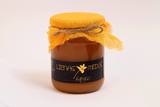 |
Семейное предприятие, которое заботится о чистоте и дизайне окружающей среды, занимается выращиванием биологической продукции. Предлагается экскурсия на пасеку и осмотр хозяйства, дегустация продуктов. |
|
 |
The owners are in the process of renewing a more than a hundred-year-old wooden barn, where they plan to organize creative workshops for young people, with the participation of a blacksmith, carpenter and other craftsmen. The owner teaches how to plat a paling. There is a possibility to get to know farm animals – rabbits, chickens, ducks, goats, etc. The house of useful arts is going to be opened in May 2014 |
|
 |
Пейзажный парк усадьбы Пакруойис, чья структура сохранилась до наших дней, был разбит в 1850–1860 гг. С одной стороны естественную границу территории образует полоса запруженной реки Круойи, а с другой парк обнесен оградой из диких валунов. Согласно популярной в те времена английской схеме формирования парков преимущество отдавалось дикой природе и имитации естественности. В парке растет около 26 наименований деревьев, среди которых можно найти и редчайшие растения из различных уголков мира, привезенные сюда более сотни лет назад. |
|
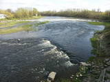 |
Above and below the town of Kuldīga, the Venta River is distinguished by a variety of biotopes – hillside forests, sandstone and dolomite cliffs, meadows, protected plants and animals, and diverse landscapes. There are popular tourism objects in this part of Kurzeme – the Venta dam, the stone bridge of Kuldīga, the Veckuldīga castle hill, etc. An ecological tourism trail runs along the banks of the Venta, and a bicycling trail has been installed on its left bank. |
|
 |
One of the biggest castle hills in Estonia, which is surrounded by walls built of stone. It is mentioned in Livonian Chronicle of Henry as one of the best fortifications at that time. |
|
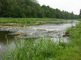 |
This park was set up to protect the lovely ancient valley of the Dubysa River. This is one of the most popular rivers for water tourism in Lithuania, because it has a significant drop with rapids and beautiful shorelines.
|
|
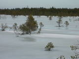 |
A comparatively large swamp to the North of the Zaļā dune, this is an important place for sulphurous waters, just as is the case with Zaļais swamp. The swamp is cut in two by the 3.5 km Ķemeri-Antiņciems road, from which interesting landscapes can be seen. The road is not appropriate for cars, however. To the East of Raganu swamp is Lake Putnezers, which is difficult to access. There is a small car park with an information stand on the shore of Lake Melnezers alongside the Ķemeri-Jaunķemeri road. The historical and overgrown Old Ķemeri road can be used to get to the seashore from this location. |
|
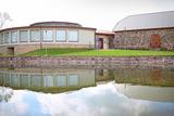 |
Модный и современный центр (в объединении со старым – отреставрированным амбаром) с выставочным залом, исторической экспозицией, местом для торговли изделиями ремесленничества и конференцзалом. Здесь работают ремесленники края, за которыми можно понаблюдать за работой и поработать вместе с ними. |
|
 1 день
|
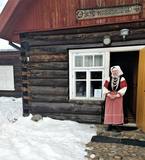
Setomaa has been inhabited for about 8,400 years, which makes it one of the oldest human settlements in Estonia. It is located on the border of Eastern and Western civilisations, bordering Russia, Latvia and Estonia. Setomaa is famous for its well-preserved traditions and culture. For centuries the local handicraft skills have been passed down within families. Seto polyphonic singing (Seto leelo) is inscribed on the UNESCO List of the Intangible Cultural Heritage of Humanity. Setos have distinctive national costumes, rich in detail and unique to each family. Perhaps most impressive is the distinctive array of Seto jewellery. These visually striking pieces not only reflect the social standing of the wearer but are also worn as a safeguard from misfortune. To this day, the Seto lifestyle remains closely tied to nature. It is common practice for the Seto not only to enjoy the natural beauty of the forest but to also use its gifts. Berries and mushrooms are picked freely in their seasons. It is best to start the tour from Võru and finish in Tartu. |
|
|
|
Prepared blood sausages both traditional and more modern. The farms offer sausage-making demonstrations for various interest groups. Farm sausages are special with the prize won at the Riga Food exhibition - People's Taste. Open at any time by prior arrangement. |
|
 3 дня
|
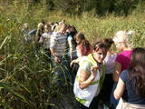
This route section takes you to the Dzūkija National Park – it is among Lithuania’s most forested and desolate nature areas –, and to the town of Druskininkai – a popular SPA and mineral water health resort on the banks of the river Nemunas. When in Druskininkai, we recommend dipping yourself in mineral water baths, enjoying the trip with the cable car over the river Nemunas, visiting the musical fountain, and walking along the river promenade. The starting point of the hiking route is the village of Didžiasalis, which is reached by bus from Druskininkai. From there, the route will take you through vast coniferous forests, rich in berries and mushrooms, and small villages. As you get to Druskininkai, the Forest Trail will meander along the small streets and parks of the historic resort of Druskininkai, crossing the river Ratnyčia and the forest park on the right bank of the Nemunas valley. Leaving the resort town behind, the Forest Trail runs on the side of the village revealing you the beautiful landscapes and the view of the Liškiava monastery on the other bank of the river Nemunas. Up to the village of Žiogeliai, the route goes along forest roads and continues along the banks of the Nemunas valley, surrounded by the vast Dzūkija forests. Towards the end of the route, climb up the Merkinė Mound and it will surprise you with breathtaking views of southern Lithuania. |
|
 |
Kaut arī Augštaitijas nacionālo parku uzskata par floristiskā ziņā ļoti bagātu teritoriju, šī ir vienīgā vieta, kur varam iepazīt augu valsts bagātību. To īstenot palīdz takas malās izvietotie informācijas stendi. 3,8 km garās lokveida takas sākums ir meklējams Palūšē, Lūšu (Lūšiai) ezera galējā austrumu punktā. Taka ved gar ezera krastu, mežainām kāpām, nelielu strautu ielejām un pa purvāju. Nenomaldīties palīdz krāsu marķējums uz koku stumbriem. |
|


