
| Нo | Название | Описание |
|---|---|---|
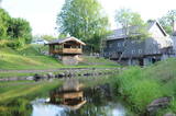 |
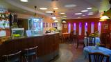
«Мельница ангелов» - старинная усадьба на берегу реки, где с 1851 г. функционировала водяная мельница. Это не просто усадьба сельского туризма. |
|
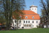 |
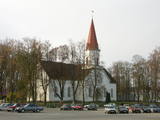
Впервые название Цесис упомянуто в 1206 году в хрониках Индрика. Первые сведения о городе исходят из Риексту калнса (Ореховая гора), именно здесь в XI - XIII вв. находился укрепленный деревянный замок вендов. Примерно в 1209 году немецкие крестоносцы приступили к строительству каменного замка, который вскоре стал политическим центром Ливонского ордена. В конце XIV - начале XV века Цесис становится членом Ганзейского союза и на протяжении столетия переживает стремительный расцвет. До XVI века на городе почти не отразились различные военные и боевые действия, но последующие события существенно изменили вид и образ жизни города. Новый этап расцвета город испытывает во второй половине XIX века – со строительством Видземского шоссе (1889 г.) и железнодорожной линии Рига – Валка (1889 г.). В 1919 году здесь происходили важные для истории Латвии бои за освобождение. В советские годы был очень популярен туристический объект здоровья и отдыха - санаторий «Цирулиши». В наши дни Цесис и развалины замка (построен современный центр для посетителей) являются одним из популярнейших мест латвийского туризма. |
|
 1 день
|
Tūrisma gide Ineta Jansone piedāvā ekskursijas grupām uz Ķemeriem un iepazīstina ar Ķemeru kūrorta vēsturi. Kopš seniem laikiem Ķemeri slaveni ar to, ka šeit ir daudz sērūdeņu avotu un ārstnieciskās dūņas. Šurp brauca ārstēties kopš 19. gs. sākuma. 1838. gadā Ķemeros nodibināja kūrortu. Ķemeru kūrortā ārstēja ādas un kaulu slimības, kā arī gremošanas un nervu sistēmas slimības. 1877.g. izbūvēja dzelzceļa līniju Rīga - Tukums, bet 20.gs. sākumā tika ieviesta tiešā dzelzceļa satiksme ar Maskavu. Kūrorts bija ļoti populārs un katru gadu arvien vairāk viesu brauca šurp ārstēties. Īsi pirms I Pasaules kara atklāja elektriskā tramvaja satiksmi starp Ķemeriem un jūru - Jaunķemeriem. Ķemeri atrodas starp purviem un ezeriem, 6 km attālumā no Rīgas jūras līča. |
|
 |
Where the little Rumbiņa river flows into the Daugava (on the left bank of the little river opposite the Lielvārde park), there is the Dievkalns castle hill that has been reduced by the waters of the Daugava. It is also known as the Cepure hill. According to antiquities that have been found here, representatives of Baltic tribes lived here from the first millennium BC to the 6th or 7th century AD. The level of the Ķegums hydroelectric power plant can be reached by a staircase from which the best view of this object can be found.
|
|
 |
This reserve dates back to Lake Ancilus, which was one of the original elements of what is now the Baltic Sea. The lake’s ancient shores feature wetlands, forests and flora which are all protected by the reserve.
|
|
 |
The tower on the eastern shore of Lake Engure (next to the meadow for wild cattle, accessible from the side of Bērzciems) offers a view of the reeds, small islands, Great Island, cows and horses of the north-eastern part of the lake. The tower on the northern shore of the lake (accessible from the side of Mērsrags) offers a look at the boating facility and the very overgrown northern part of the lake. The tower at the north-western shore of the lake (accessible from the side of Ķūļciems) shows the Apaļrova island (a footpath), stands of juniper, the boating facility, and the mosaic-like landscape of the lake itself.
|
|
 |
Предлагают экскурсию по хозяйству, где можно увидеть коз, лошадей, кроликов, птиц и домашних животных. Интересующиеся могут записаться на сеансы рейттерапии, покататься верхом на лошади, пони и в подводе. Приобретение продукции козоводства – молока, сыра, творога, кефира и йогурта. |
|
 1 день
|
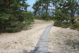
This section of the Baltic Coastal Hiking Route is a comparatively short hike across a beautiful sandy beach, the coastal side of which is bounded by brightly colored pine forests with spectacular dunes and dams of dunes. To get from the beach to Carnikava, the Baltic Coastal Hiking Route will take you through a forest via a promenade. Then it takes a stroll around the Old Gauja River via a levee and reaches the pedestrian bridge over the Gauja River. Both as you start and end the hike, it is nice to sit in one of the pubs and summer cafés located on Vecāķi beach and in Carnikava. |
|
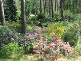 |
Проект по развитию дендрария начался в 1996 году, когда дендрологи Саласпилсского ботанического сада Раймондс Циновскис, Инара Бондаре и представители самоуправления Руцавы договорились о создании экспериментальных посадок на холме усадьбы Руцава. Посадка насаждений была начата в 1998 году. В дальнейшем, посадка растений проводилась также в центре Руцавы и у начальной школы. Посадки ежегодно пополняются новыми и экзотическими экземплярами растений со всего мира. Праздник сада традиционно проводится в мае, во время цветения рододендронов и магнолий. |
|
 |
Исторический камень, на котором заметен высеченный более 200 лет назад пограничный знак, указывающий на бывшее место границы между Курземским герцогством и Российской губернией. В наши дни - это граница Бабитского и Елгавского края. Камень находится к востоку от дороги Калнциемс – Кудра (на юге от болота Лаба) на краю лесной просеки, и несведущему может быть трудно его найти. Для этой цели пригодится описание пути: примерно в 400 метрах к югу от автостоянки у озера Лилий с дороги Калнциемс - Кудра вправо (на восток) уходит лесная дорога, которая ведет вниз от гор Крачи. По дороге надо пройти примерно метров 170, до тех пор, пока она резко не повернет вправо (на юго-восток). Потом следует идти в упомянутом направлении и примерно через 0,5 км повернуть на северо-восток, после чего еще ~ через 0,4 км на очередном лесном перекрестке повернуть на север. Через ~ 0,4 км на большой просеке надо повернуть направо (на восток), с левой (северной) стороны просеки за мелиорационной канавой в безлиственный период уже виден округлый каменный этаж. Из-за плохого состояния дороги до камня можно дойти только пешком. |
|
 |
The café serves freshly prepared home-cooked food. "Cafe 21 & Putnu Dārzs" rents out rooms for banquets, celebrations, meals, buffets and seminars. Provides food delivery and off-site service. |
|
 |
До XIII века Смилтенский край входил Талавскую землю, заселенную латгальцами. После вторжения крестоносцев им завладел Рижский архиепископ, возведя на крутом берегу реки Абулы в 1370 году каменный замок. Последующие войны и эпидемии не сберегли ни застройку населенного места, ни жителей. Очертания теперешнего города начали проявляться в конце XIX века в связи с активными действиями князя Ливена - владельца имения «Смилтене». До Первой мировой войны в Смилтене работала деревообрабатывающая фабрика, гидроэлектростанция (1901 г., первая в Балтии) и др. предприятия. Во время пожара, при отступлении немецких войск в 1944 году, сгорела большая часть исторической застройки Смилтене. |
|
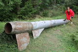 |
Der weiteste Nordpunkt der Juminda Halbinsel mit einer Raketen-Attrappe der Sowjetarmee, der alten Grabstätten, dem Juminda-Leuchtturm und einem Denkmal für die Opfern des Zweiten Weltkriegs. |
|
 1 день
|
Kihnu Island is the largest island in the Gulf of Rīga and the seventh largest island in Estonia. Its total area is 16.9 km², the island is 7 km long and up to 3.3 km wide. The former seal hunter and fishermen’s island, with around 600 inhabitants, is currently eager to maintain its identity in spite of everything. The unique characteristics of the Kihnu cultural space, like the lifestyle of the community, the diverse cultural traditions, the Kihnu language, music, national costumes and nature, are included in the UNESCO cultural heritage list. A coastal route that goes through four villages – Sääre, Linaküla, Rootsiküla and Lemsi - will help you to discover the cultural and natural values of Kihnu Island. You can visit Kihnu Museum all year round and get insight into the history of the island, including the life of the famous local captain, Kihnu Jõnn. It is also worth seeing Kihnu Church and the cemetery located across from the museum. In the summer, you can enjoy a beautiful view of the island, the surrounding sandbanks and the sea from the lighthouse. The commemorative stone by the former house of Kihnu Jõnn introduces you to the island’s legendary “wild captain”. |
|
 |
Das Museum befindet sich in der Festung von Kopgalis. Im Aquarium des Museums sind Fische und Tiere der Ostsee und anderer Meere und Ozeane zu sehen. Eine Ausstellung. Pinguine und Seehunde. In den Pulverkellern der Festung ist eine Ausstellung der Seefhrt Litauens, aber auf den Bollwerken eine Ausstellung der Gewehr eingerichtet. Das einzige Delfinarium im Baltikum. |
|
 |
This is a comparatively large lake (3 km long and 1.3 km wide). It is shallow (no more than 1.1 m deep) and is classified as a seashore lake. The Vecslocene River flows through it. At the southern end, there is a narrow stream which connects Lake Sloka with Aklo Lake – a shallow and small lake with a dolomite bed at some locations. The best view of Lake Sloka can be seen from the bird watching tower on its north-western shore. This is the only floating bird watching tower in Latvia. Alongside it is the beginning of the 3 km Lake Sloka hiking trail, which passes through the flooded wetlands of the lower reaches of the Vēršupīte. An information stand can be found on the shore of Lake Sloka by the car park. Beyond it is a sulphurous spring. |
|
|
|
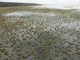
Atrodas Sedas purvā (Sedas dabas takas malā) ar plašu skatu uz izstrādātajām kūdras platībām. Sedas taku ieteicams izstaigāt vietējā gida pavadībā T: + 371 2636162. |
|
 |
Pajumäe ‒ это маленькое симпатичное биологическое хозяйство, которое находится в зеленом регионе Мульгимаа и производит различные молочные продукты. Здесь Вы сможете увидеть все этапы производства молока ‒ от выпаса коров на пастбище до обработки сырья на молочном заводе. |
|
 |
This is a forested island in the Bay of Finland which is the 6th largest Estonian island and is found 14 km to the N of Tallinn. Two decades ago it was a closed zone, because the Soviet Union had a highly secretive manufacturing plant for maritime mines here.
|
|
 |
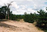
Познавательная тропа длиной 1,2 км знакомит с многовековыми, занесенными песком соснами. У тропы – в конце бывшего «тира» (полигон Советской Армии) - построена смотровая башня. |
|


