
| Нo | Название | Описание |
|---|---|---|
 |
Из натурального, самими выращенного или купленного у местных крестьян сырья, по методам предков делают яблочное, ревеневое и черносмородиновое вино и черносмородиновый спирт. Во время экскурсии можно познакомиться с процессом приготовления напитков, продегустировать и купить уже готовые продукты в магазинчике хозяйства. |
|
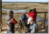 |
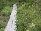
Каниерис сильно заросшее и
мелководное приморское озеро, уровень
воды которого неоднократно регулируется в
20 столетии (цель получение земель для
сельскохозяйственного использования). В
озере насчитывается 14 островов, девять из
которых являются естественными, а
остальные искусственно созданными для
привлечения гнездящихся водоплавающих
птиц. Каниерис одно из богатейших птичьих
озер Латвии. Еще в 1964 г. здесь был создан
орнитологических заказник Каниерского
озера, в 1989 г. озеро включили в список
важных птичьих объектов Европы, а в 1995 г.
в список Рамсарской конвенции. На юго
восточном берегу озера расположена
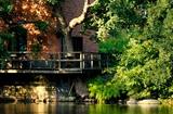
Лодочная база (по озеру Каниерис
разрешается ходить только на прокатной
лодке). В 2009 г. на полуострове Риекстусала
построили башню для наблюдения за
птицами.
|
|
 |
Ap 0,5 km ziemeļaustrumos no Stukmaņu muižas – Daugavas ielejas labajā krastā atrodas Vīna kalns – sens pilskalns. Tajā atrodas izpostītie Stukmaņu muižas īpašnieku kapi. Mazliet tālāk redzams klajš upes ielejas nogāzes posms, kurā savulaik darbojās slēpošanas trase. |
|
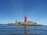 |
Колкский маяк – на искусственно созданном острове в море (остров
создан в 1872 – 1875 гг.) изначально был построен деревянный маяк, огни на
котором зажглись в июне 1875 года. Когда остров осел, здесь была построена
теперешняя башня маяка, которая начала свою работу 1 июля 1884 года.
Современный маяк находится на расстоянии 6 км (в момент постройки – 5 км)
от Колкасрага, в конце подводной песчаной мели. Еще на острове находится
здание смотрителя маяка и несколько хозяйственных построек. Металлическая
конструкция башни маяка высотой в 21 метр изготовлена в Санкт-Петербурге.
С 1979 года маяк работает в автоматическом режиме.
|
|
 |
This trail's purpose lies on the fact that herbal therapy is the oldest known system of medicine. Being outside, in fresh air, in nature affects our health positively. While hiking with a phytotherapist you will get to know more about the nature's wild herbs that can help our livelihood and also do some light exercises. If you want, you not can only walk the trail but also relax in a sauna or/and visit a workshop. |
|
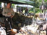 |
В мастерской кузнеца выставлены работы - фонари, подсвечники, петли, приспособления для камина, перила для лестницы, ворота, а также экспонаты 18 века. Посетители могут сами выковать гвоздь. «Проверки» молодых пар у кузнеца. Принимаются заказы. |
|
 |
Teritorijas apskates nolūkos ir izveidota un labiekārtota dabas izziņas taka. Dabas liegums atrodas Abavas senlejas dabas parka teritorijā. Taka iepazīstina ar vienīgo krūmu čužas savvaļas augšanas vietu Latvijā. |
|
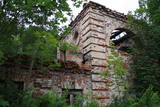 |
Atrodas Kraujā – Daugavas ielejas krasta malā un nogāzēs. Atrodama informācija, ka šajā vietā Livonijas kara laikā atradusies krievu karaspēka nometne. Muižas nosaukums cēlies no vācu Hof zum Berg – „Kalnu muiža”. Pēdējie muižas īpašnieki līdz 1. pasaules karam bija grāfu Šahno dzimtas pārstāvji. Viens no tiem – Marians Šahno 1910. gadā uzceļ muižas pili, kas bija būvēta eklektisma formās. Daļēji nojaukta tā pārdzīvo padomju laikus, līdz 2002. gadā nodeg. Līdz mūsdienām saglabājušās vien ēkas sienas, kuras slēpj biezs augājs. Var tikai iedomāties, kādi skati šeit kādreiz pavērušies uz Daugavas ieleju! Muižas parks ir vietējo iedzīvotāju pastaigu vieta. |
|
 |
Проезжая по северному берегу Саукского озера (где перекресток на Клауци), сквозь деревья просматривается Саукская лютеранская церковь. Это третий храм на этом месте. Открытие состоялось в 1827 году, осмотру подлежит г.о. извне. Церковный алтарь украшен скульптурами апостола Петра и Павла и алтарной иконой Й.Деринга «Иисус у креста с Марией и Иосифом». Орган - работа елгавских ремесленников, но трубы органа - из Саукас.
|
|
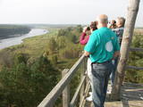 |
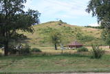
Старая деревянная башня была снесена, и на ее месте сейчас построена новая вышка. С построенной в 2015 году вышки открывается один из самых красивых природных видов Латвии, который в свое время был изображен на 10-латовой банкноте. Вид на эту излучину Даугавы считается самым красивым на протяжении всего течения реки. |
|
 |
Svartå Manor is one of the most precious manor houses in Finland with a history of more than two hundred years. The countryside hotel consists of five different historical buildings situated in an idyllic park with a scenic river flowing nearby. Near the manor is a restaurant and a museum, where you can take a tour. |
|
 6 дней
|
Этот маршрут позволит Вам увидеть самые впечатляющие средневековые замки Латвии или их руины, равно как и знаменитые особняки в аристократических поместьях, датируемые 18 и 19 веками. Особняк поместья Унгурмуйжа – единственный из уцелевших в Латвии деревянных дворцов из тех, что были построены в начале 18 века. Развалины Цесиского замка – в числе наиболее впечатляющих средневековых развалин в стране. Башня Турайдского замка предлагает панорамный вид на старинную долину реки Гауя. Около половины маршрута проходит через Национальный парк Гауя. Вы прибудете в место существования самой старинной переправы на балтийских реках – плоты, которые перевозят людей через реку, до сих пор приводятся в движение течением. В качестве мест для ночлега выбраны баронские поместья и замки, где это возможно. Вас будут кормить в ресторанах высшего класса или в местах, где Вы сможете попробовать традиционную латышскую еду и насладиться местной атмосферой. |
|
 |
Alūksnes novada saimniecībā "Pauguri" kokamatnieks Jānis Vīksne izgatavo koka virpojumus - cibiņas, pulksteņus, pildspalvas, spēles, šūpoles un citas saimniecībā noderīgas lietas. Iespējams iegādāties kokamatniecības suvenīrus - dekoratīvus un praktiskus virpojumus no koka. Senlietu muzeja apskate - seni galdniecības darba galdi, ēveles, āmuri, sirpji, grābekļi, sējmašīna, pulksteņi, trauki u.c. Saimniecībā ir izveidota skatu platforma, no kuras paveras skats uz Hānjas augstienes ainavām Igaunijā, kā arī atpūtas vieta vasaras piknikam ar galdu, uguskura vietu un skulptūrām. |
|
 |
Городище Бусе (Маткулес) находится в изгибе берегов реки Имула. С него, на противоположный берег Имулы открывается один из самых живописных видов на речушки Курземе. Видом лучше всего любоваться в безлистный период, когда ландшафт не закрывает береговая растительность. В округе разбиты тропы для пеших прогулок. |
|
 |
Darbnīcā tiek izgatavoti personalizēti pulksteņi un dažādi dizaina priekšmeti no koka, kā arī piedāvātas kokapstrādes meistarklases vai klātbūšana dažādos materiāla pirmsapstrādes vai finiša apstrādes procesos. Tāpat iespējama ekskursija pa darbnīcu un koku sugu atpazīšanas viktorīna. |
|
 |
В доме «Берзини» выпекают чудесный на вкус пшеничный и ржаной хлеб по старинным родовым рецептам. Вкус и аромат хлебу придает особая печь, которой более 70 лет. Хлеб можно заказать, или, договорившись заранее, сделать и испечь самому свою буханку. |
|
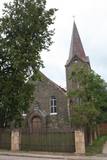 |
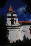
Atrodas Raiņa ielā 18. Baznīca celta 1911. - 1912. g. pēc Stukmaņu muižas nomnieka barona R. Noldes iniciatīvas. 1. pasaules karā cietušo baznīcu atjaunoja un no jauna iesvētīja 1921. g. Baznīcā apskatāma altārglezna “Kristus augšāmcelšanās”. Dievnams tāpat kā daudzas citas pilsētas ēkas ir būvētas no apkaimē sastopamā izejmateriāla – dolomīta. Interesanti, ka tornis būvēts ēkas vienā malā – asimetriski. |
|
 |
Всего лишь в 20 минутах езды от Пярну, в старом здании лесничества Tõstamaa, находится кафе Amps & Lonks, которое предлагает путешественникам немного отдохнуть и подкрепиться пиццей, приготовленной из свежих местных продуктов. Особой популярностью пользуется пицца с говядиной, выращенной здесь же, в хозяйстве, и свежий салат. Также можно делать заказы заранее. |
|
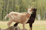 |
Хозяйство специализируется на выращивании коз и производстве козьего сыра. Осмотр хозяйства с дегустацией и приобретением продукции. Посетители могут понаблюдать за стадом коз (около 150 коз), приобрести и продегустировать сыры. Серцифицированное биологическое хозяйство и хозяйство здоровой окружающей среды. |
|
 |
В настоящее время территория бывшего советского противовоздушного дивизиона в Юркалне находится в частной собственности, где обустроена мототрасса.
|
|


