
| Нo | Название | Описание |
|---|---|---|
 |
«Кайкайши» находятся ~ 1 км к юго-западу от центра Вецпиебалги, в небольшом поселке Кайкаши. В «Кайкаши» родился латышский писатель Антон Аустриньш (1884 – 1934). В Вецпиебалге будущий писатель получил основное образование. Одна из самых известных работ А. Аустриньша это сборник рассказов «Мальчуган» (1931). Музей, в котором представлены различные экспонаты и предметы сельского быта, связанные с жизнью писателя (также написанные сборники и книги), желательно осматривать в сопровождении местного гида. |
|
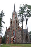 |
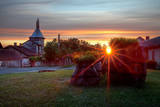
Found in the northern part of Cesvaine, the church was built of fieldstones in the Neo-Gothic style in 1879 by the architect Paul Max Bertschy. The church was restored in 1929 and again in the early 1990s. The altar painting, “Christ on the Cross” (1923) is by Jēkabs Bīne.
|
|
 |
Место для отдыха находится на южном берегу второго по величине озера Латвии с красивым видом на озеро. Готовят латгальские блюда из местных и выращенных в хозяйстве продуктов. Латышская кухня: Гульбешники и клёцки со сметанным соусом. |
|
 |
В хозяйстве Suhka соблюдают старинные традиции и подают блюда местной кухни. Также предлагаются места для ночлега, расположенные в живописном месте. Кроме того, здесь Вы можете узнать маршруты походов по таким местам, которые самостоятельно найти очень трудно. |
|
 |
В мастерской, которая обустроена в сельском дворе, ткут одеяла, ковры, дорожки для пола, скатерти, подушки, плетут корзины, подносы и сувениры, на заказ делают народные костюмы, демонстрируют процесс ткачества и плетения из прутьев. |
|
 |
По индивидуальным заказам делает элегантные предметы интерьера - деревянную мебель (шкафы, кровати), лестницы и др. полезные в хозяйстве дела. Поделится знаниями и опытом. Автор нескольких деревянных алтарей. |
|
 |
Винодельня Tori ‒ это аутентичный крестьянский хутор Soomaa, где выращивают яблони и виноград, а из собранного урожая делают вино и сидр. В хозяйстве можно узнать секреты приготовления хорошего сидра и вина, познакомиться с особенностями культивации северного винограда; также здесь оказывают услуги питания и проводят дегустации. |
|
 5 дней
|
На маршруте встретятся уникальные и в Латвии до сих пор невиданные пейзажи! Внушительный обрывистый берег Балтийского моря, протяженностью почти двадцать километров, начинается несколько километров севернее Павилосты и заканчивается недалеко от Ошвалки. Берег впечатляющей и необычной формы простирается на участке от Странте до Улмале. Маршрут на всем протяжении ведет по бывшей западной границе «Железного занавеса», так как в советское время берег Балтийского моря был милитаризованной и людям «со стороны» недоступной территорией. В настоящее время также еще можно увидеть остатки бывших армейских объектов и старые танковые дороги в прибрежных дюнах. В окрестностях Вентспилса и Ужавы на протяжении нескольких километров простираются самые большие биотопы серых дюн в странах Балтии. Это необычные ландшафты, которые редко можно увидеть в других метах Европы. Здесь можно пройти более десяти километров и не встретить ни одного человека. Maršruta informācija no Latvijas Lauku foruma |
|
 7 дней
|
Пиво и рыба – важная часть латышского наследия. Этот тур познакомит вас с Латвией в свете этих двух фундаментальных компонентов. Находясь в Риге, вы отведаете пиво из всех четырех регионов Латвии и типичные закуски – в качестве введения. Затем маршрут ведет в деревню. Сначала будет остановка в Баусской пивоварне, которая гордится своей продукцией без консервантов. Затем визит во Дворец Рундале и на реконструкцию старинного семигальского замка в Тервете. По плану визит в пивоварню Тервете, которая является частью мультифункциональной агрокомпании. Все составные компоненты их пива производятся местными производителями. На следующий день вы увидите, как производится пиво в домашних условиях традиционными способами и почуствуете разницу. А затем маршрут ведет в Лиепаю. В этом городе найдете красивый пляж из белого песка, художественный центр города и внушительное военное наследие в пригороде Караоста, который в настоящее время используется в основном туристами. Затем маршрут идет в маленький живописный городок Кулдигу с ее хорошо сохранившимся деревянным зодчеством и самым широким водопадом в Европе. И еще один визит в пивоварню – на этот раз Ужавскую- которая специализируется на живом пиве. Затем осмотр достопримечательностей в портовом городе Вентспилс и рыбацкий обед и игры в маленьком портовом городке Роя. На следующий день погуляйте утром по пляжу, а затем отправляйтесь с экскурсией в дом рыбака, чтобы понаблюдать за процессом копчения рыбы. А потом маршрут поворачивает обратно к Риге, с прогулкой по таинственному болоту в Национальном парке Кемери и остановкой на морском курорте Юрмала, с ее характерными деревянными виллами 19 века и ланчем в ресторане картофеля. |
|
 |
The ancient Abava River Valley between Kandava and the place where the river flows into the Venta River is the most expressive river valley segment in Kurzeme in terms of landscape and terrain. The valley is 30 to 40 metres deep and as much as 300 metres wide. The territory is distinguished by great diversity of a biological nature (more than 800 kinds of plants), featuring many different biotopes and natural monuments such as streams, waterfalls, cliffs, huge rocks, and many cultural and historical monumentssmall towns such as Kandava and Sabile. In both cases, the town centres are national monuments of urban construction. Popular tourist destinations include Vīnakalns hill in Sabile, where wine-making grapes are grown, as well as the open-air art museum at Pedvāle. To protect cultural treasures, a cultural and historical territory, “Abava River Valley” has been established. Wild livestock live at Drubazas and Tēvkalni to “maintain” the landscape. There are nature trails for tourists, and the Abava is the most popular river for water tourists in Kurzeme. Information is available at the tourist information centres in Kandava and Sabile. such as castle hills, churches, ancient burial grounds, and
|
|
 |
Канал военного порта и размещенная там база военного флота и подводная база были вырыты по приказу Российского царя еще перед Первой мировой войной. Территория подводного порта в настоящее время закрыта и используется для хозяйственных нужд. Канал военного порта просматривается со стороны улицы Пулвера и восстановленного моста Калпака.
|
|
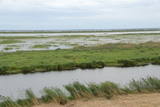 |
Dabas liegums atrodas dienvidaustrumos no Lubāna ezera un tas veidots purva un meža biotopu un tajos esošo sugu aizsardzībai. Gar teritorijas ziemeļu robežu iet Nagļu - Degumnieku ceļš (iekļaujas kopējā Lubāna dambju sistēmā), pa kuru apkārt Lubāna ezeram izveidots velomaršruts. Tas nozīmē, ka teritoriju var aplūkot arī "no malas", netraucējot tās dabiskās norises. Teritorija ietilpst arī Lubāna mitrāja kompleksā.
|
|
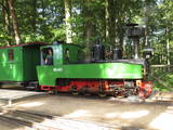 |
Это великолепная возможность вернуться в прошлое – во времена, когда на территории Латвии «господствовал» период узкоколейной железной дороги. Вплоть до 60-х годов прошлого столетия на Северокурземском побережье действовала узкоколейная железная дорога, соединявшая прибрежные рыбацкие поселки. До сего дня сохранились места (еле различимые коридоры на фоне природы), отдельные станционные здания или их остатки. В Вентспилсском Приморском музее под открытым небом можно с интересом проехаться по Круговой линии протяженностью 1,4 км или Горной линии протяженностью 3 км, в конце которой находится поворотный круг. Локомотив узкоколейки был построен в 1916-м году в Германии. Можно также осмотреть станционное здание со всем оборудованием. |
|
 |
Rekovas dzirnavas ir unikāla vieta pašā austrumu pierobežā. “Pirmajā stāvā bija miltu malšana un otrajā stāvā apstrādāja vilnu. Dzirnavas pastāvēja līdz 1980.gadam. Vēlāk ēka nevienam nepiederēja, lietus ietekmē iebruka jumts un faktiski viss bija sadrupis. 2016.gadā zemnieku saimniecības “Kotiņi” saimniekam Aldim Ločmelim radās iespēja iegādāt ēku un saliekot galvas kopā, radās ideja, ka ēkā varētu būt vietējās produkcijas veikaliņš.” Majestātiskā trīsstāvu pamatīgu laukakmeņu mūra ēka, kas atrodas pašā Balvi-Viļaka ceļa malā, ir sākusi dzīvot jaunu dzīvi, kur ikvienam ir iespēja nobaudīt vietējo Latgales produktu garšu dažādā izpildījumā. Dzirnavu saimniece - viena no īstajām latvju saimniecēm Vija Kuļša uzņem tūristu grupas, kurām piedāvā nobaudīt vietējo Latgales produktu garšu dažādā izpildījumā. Ēdienkarte sastāv no piedāvājuma vegāniem, veģetāriešiem un klasiskās ēdienkartes. Viena no galvenajām ēdienu sastāvdaļām ir zs “Kotiņi’’ ražotā produkcija. Ir iespēja pieteikt un darboties arī Meistarklasēs. Tiek piedāvāvāts ēdiens no linsēklām, linu eļļa, dažādi salāti, ko var gatavot ar linu eļļu. Linsēklas izmanto pašu ceptā maizītē, sāļajā baltmaizē ar linsēklām. Linsēklas Rekovas dzirnavu ēdienkartē ir tikai viena no izejvielām, bet tieši tās ir centrālais varonis jaunajā Ziemeļlatgales kultūrvēsturiskā tūrisma piedāvājumā “Linu ceļš Ziemeļlatgalē”. |
|
 |
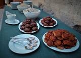
Трактир обосновался в старинном срубе неподалеку от Лиелпупской церкви. В старом амбаре рядом с трактиром по рецептам предков делают мясные и колбасные изделия, которые можно купить в мясной и колбасной лавке Sidrabiņi. Предлагаются экскурсии и дегустация продукции. |
|
 |
В историческом ледовом погребе мызы Alatskivi делают вино, травяные чаи, съедобные сувениры, пряный уксус и варенье из урожая, собранного в окрестных лесах и полях. В уютном магазинчике можно продегустировать и купить вино, чаи и другие местные съедобные сувениры. Если Вы хотите навестить нас большой группой и в нерабочее время, то желательно сообщить о своем визите заранее. |
|
 |
Поселение расположено между улицей Пиладжу и левым берегом Силиньупе. В III–II тысячелетии до нашей эры здесь находилось поселение рыбаков и охотников, на месте которого установлен информационный памятный камень (скульпт. О. Скарайнис). Силиньупское поселение – наиболее известное место поселения древнего человека на территории Кемерского национального парка. Здесь найдены многие старинные предметы: осколки глиняной посуды, наконечники стрел, кусочки кремня и янтаря и др. Возможно, что на территории соседних частных домов находился могильник поселения. Небольшую часть находок можно увидеть в Лапмежциемском музее, остальные находятся в Латвийском Национальном историческом музее. |
|
 |
MIGLA ir mazā alus darītava, tas ir sens saimnieka sapnis, kurš realizējies, spēkus apvienojot kopā ar jaunāko meitu. Alus garšu meklēšanā, receptūru izstrādē, kā arī novērtēšanā piedalās visa ģimene, kur īpašas alus someljē īpašības piemīt vecākajai meitai. Apvienojot visas ģimenes stiprās puses - darītāju, runātāju un garšu pazinēju un dizaina ekspertu, tapis MIGLAS alus, kas šobrīd piedzīvo savus pirmos soļus alus pasaulē un cer iepriecināt ne vienu vien alus baudītāju! Lielu daļu alus darīšanas tiek veikta ar rokām, svērti un malti graudi, rēķināts ideālais apiņu un graudu daudzums, tiek liets, pārliets un skalots. Darītava laprāt uzņem viesus degustācijām, kurās piedāvā ne tikai nogaršot alu, bet arī cienā ar pašceptu maizi un cepumiem, kā arī iepazīstina ar alus darīšanas procesu un vēsturisko Uzvaras Līdumu, kurā atrodas alus darītava. Mazais brūzis atrodas vienviet ar Ķiploku pasauli - otru ģimenes aizraušanos, tāpēc uzreiz var apskatīt divas saimniecības. |
|
 |
Atrodas Amatas ielejas augstajā krastā, autoceļa (A 2) Rīga – Veclaicene malā. Plašs ēdienu klāsts, lielas porcijas, iecienīta tālbraucēju šoferu maltītes ieturēšanas vieta. |
|
 |
Tiek uzskatīta par vecāko alus darītavu Ziemeļeiropā. Tā tika uzcelta 1878. gadā, un tās pirmais īpašnieks bija grāfs Emanuels fon Zīverss (Sievers), Cēsu pils muižas saimnieks. Savukārt 1922. gadā alus darītavu pārpirka Cēsu uzņēmēji un sāka tur ražot arī vīnu, sulas un minerālūdeni. Uzņēmums "Cēsu alus" šeit alu un atspirdzinošus dzērienus ražoja no 1976. līdz 2001. gadam, bet šobrīd tas ir pārcēlies uz jaunām telpām. Šobrīd ēkā tiek organizētas dažādas izstādes, kā arī ēku var apskatīt no ārpuses. |
|


