
| Нo | Название | Описание |
|---|---|---|
 |
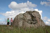
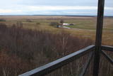
Lai nokļūtu līdz šim tornim, ir jāveic apmēram 20 – 30 min ilgs pārgājiens pa dabas taku no Penijē muižas gar Penijegi (Penijõgi) kreiso krastu. Te redzami bebru darbi un to celtās zaru mājas. No torņa paveras skats uz Kazari deltu, kas dabā izpaužas kā monolīts un nepārskatāms niedrājs. To vairākās daļās sadala Kazari un mazāka izmēra upītes. Katrai deltas daļai ir savs vēsturiskais nosaukums: no torņa pa kreisi no Penijegi redzama Lihula meri (Lihulas „jūra”), bet tās labajā pusē - Kloostri meri (Klostri „jūra”). Putnu vērotāji var iziet garāku (7 km) dabas takas loku, kas ved pa palieņu pļavām. Jārēķinās, ka pavasaros būs nepieciešami piemēroti apavi! Pļavas ierobežotās platībās apsaimnieko mājdzīvnieki, tādēļ neaizmirstiet aizvērt vārtiņus aiz sevis un netraucējiet to ikdienas gaitas! No maršruta nav atļauts novirzīties, lai netraucētu putnus. |
|
 |
Meklējams Matsalu līča dienvidu krastā pie Kēmu ostas (Keemu sadam). Blakus sešus metrus augstajam metāla – koka tornim uzcelts neliels apmeklētāju centrs. Tāpat kā no Haeskas torņa, arī no šī paveras viena no izcilākajām Matsalu līča un tā piekrastes ainavām. Laba putnu vērošanas vieta migrāciju laikā. |
|
 |
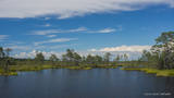
Izcila lokveida taka (4,5 km), kuras lielākā daļa (koka laipas) ved pa Rīsas purvu (Riisa raba). No takas un divstāvīgā koka skatu torņa ir vērojami purva ezeriņi, lāmas, un purvaini meži. Ja nacionālā parka apskati sāk no ziemeļu puses, tad šī taka ir labs ceļojuma iesākums! |
|
 |
Auf der Küste der Halbinsel befinden sich sowohl ehemalige Fischerdörfer, als auch die Reste eines Militärstützpunkts der Sowjetarmee. Großartige von den Gletschern des Eiszeitalters eingebrachte Feldsteine. |
|
 |
Karulas nacionālā parka lielākais ezers - 2,8 km garš, līdz 1 km plats. Ezera ziemeļaustrumu krastā atrodas parka apmeklētāju centrs. 5,5 m dziļais ezers ir gan zivīm, gan nostāstiem bagāta vieta. Ezera un tuvākās apkārtnes iepazīšanas nolūkā ir izveidota 3,5 km garā Ehijerva taka (Ähijärve teerada). Tās sākums atrodas pie iepriekš minētā apmeklētāju centra, kur izveidota atpūtas vieta un atraktīvs bērnu spēļu laukums. Taka sākumā ved gar ezera krastu, nelieliem mitrājiem un meža ceļiem, kas izmantoti iepriekšējos gadsimtos. |
|
 |
Eine von Nadelbaumwäldern bedeckte Halbinsel. Malerisches Käsmu Steinfeld, Matsikivi Stein, Vana Jüri Stein u.a. Bei passenden Bedingungen kann man sich auf einer steinernen Landzunge bis zur 0,5 km entfernt liegenden Insel Saartneem schleppen. |
|
 |
This park was set up to protect the landscape and cultural environment of the Haanja highland. At the central part of the park are the two highest hills in the Baltic States – Suur Munamägi, which stands 318 m above sea level, and Vällamägi, which is 304 m above sea level. The ancient Rõuge River valley (Rõuge ürgorg) is found in the western part of the park. It is 7.5 km long and up to 60 m deep. The valley dates back to the Ice Age, and it has seven lakes, including the deepest one (38 m) in Estonia – Lake Rõuge Suurjärv.
|
|
 |
This is the 11th largest Estonian island, and its central section is covered by a broadleaf forest (linden, oak, elm and other trees) that is more than 100 years old. Along the shores, the Abruka Island has meadows and small areas of wetlands. Only the northern part of the island is populated. Few tourists come to call, which means that the island is relatively untouched by humankind.
|
|
 |
Семейный парк Лесовницы - расположенное между холмами Кайка объединение хуторов, которое предлагает различные возможности для ознакомления с близким к природе здоровым образом жизни и народной медициной. В рамках предлагаемых хуторами программ можно познакомиться с траволечением, гирудотерапией, волшебным миром пчел и грибов, а также ощутить на себе влияние заклинаний и мест для медитации. Также можно научиться готовить блюда из сорняков, домашний хлеб и лекарство из трав. Одиночные посетители могут самостоятельно познакомиться с хутором. |
|
 |
The national park was established to protect the 100 or so small islands that make up the archipelago of the local area. The largest island, the Vilsandi Island, is 6 km long and up to 2 km wide. You can rent a boat to get there, or, during appropriate conditions, you can walk across the sea and the small islands from the southern end of the Kuusnõmme peninsula.
|
|
 |
Vom 19. Jh. ist der Domberg ein offentlicher Park mit Pfaden, Gehwegen, Brücken (Engelsbrücke, Teufelsbrücke) und den Denkmälern für die Wissenschaftler der Tartu Universität. Hier befinden sich die Domkirche, das Anatomicum, das Observatorium u.a. interessante Objekte. |
|
|
|
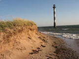
Die zweitgrößte Insel Estlands mit breiter Waldung, Sand- und Steinstränden und einem der ältesten Leuchttürme Europas. |
|
|
|
Das größte im Baltikum. Marathonloipe von Tartu, Wand der künstlichen Felsen und Trasse der Radmarathon. Skimuseum. Auf der Tehvandi-Sprungschanze ist ein Aussischtsplatform eingerichtet. |
|
 |
Durch das höchste Dünen-Massiv Estlands und den Moor führt der Lehr-Wanderweg. Blick vom Aussichtsturm bis auf die Insel Kihnu. |
|
 |
Suitsu tornis celts 1979. g. kā pirmais Matsalu rezervāta metāla tornis. To atjaunoja 1998. g. Torņa augstums ir 21 m, tādēļ no tā paveras izcila dabas un kultūrainava uz Kazari deltas niedrājiem un blakus esošo Suitsu upi (Suitsu jõgi), kuras krastā ir uzceltas vairākas zvejnieku laivu būdas. |
|
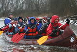 |
Компания занимается организацией природных походов: летом морские походы на байдарке, осенью на болотоступах по болоту, зимой походы на снегоступах и весной на каноэ по рекам. |
|
 |
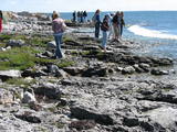
Sāmsalas ziemeļrietumu daļā jūrā iestiepjas iespaidīgā Tagameizas pussala (Tagamõisa poolsaar). Tās ziemeļrietumu daļā meklējama mazāka – ap 5 km garā Harilaidas pussala (Harilaid). Pussalas vidusdaļā viļņojas Lajalepas ezers (Laialepa järv) - bijušais jūras līcis, kas zemes garozai ceļoties, kļuvis par iekšēju ūdenstilpi. Arī pati Harilaida (igauniski „laid” nozīmē „saliņa”) vairāk nekā trīs gadsimtus atpakaļ bijusi sala. Harilaidu iecienījuši ne tikai migrējošie putni, bet arī roņi, kurus piesaista vientuļi līči un akmeņainās sēres. Harilaidu var apmeklēt tikai ar kājām vai ar divriteni, bet spēkrati ir jāatstāj autostāvlaukumā. No tā ~ 1 km attālumā atrodas vieta, kur pēc 17. gs. radies Harilaidas savienojums ar Sāmsalu. Šeit paveras nepierasti klaja un akmeņaina ainava. Pārējā Harilaidas daļa ir apmežota pirms ~ 40 gadiem. Kopumā būs jāveic ~ 10 km garš pārgājiens. |
|
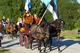 |
Туристический конный хутор Тихусе предлагает размещение и конные прогулки(от езды на коляске до конных прогулок). У хутора начинается учебная тропа древней культуры, которая уводит нас в те времена, когда человек связывал себя с силами природы, где можно познакомиться с обычаями и традициями прежних времен. Стены хуторского чайного дома украшают фотографии различных мест Мухумаа, связанных с древней культурой. |
|
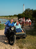 |
Занесенное в список всемирного наследия ЮНЕСКО культурное пространство Кихну (www.kultuuriruum.ee) представляет собой своеобразный сплав настоящего и прошлого. В музее Кихну есть все, что касается повседневной жизни- орудия труда, одежда, рукоделие, мебель. |
|
|
|
Very expressive form of relief with wide look over the neighborhood. On its peak there's ruins of the castle of bishop Hermanis which was built in 1224. The world's oldest firearm was found here. |
|


