
| Нo | Название | Описание |
|---|---|---|
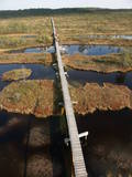 |
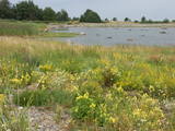
This reserve was set up to protect local swamps and surrounding wetlands. Please note that before you can visit the reserve, you must register with the local administration and visitor centre in the village of Tooma.
|
|
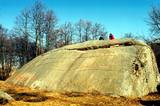 |
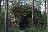
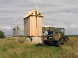
This is the second largest rock in the Baltic States in terms of size (728 m3). It is the only rock in the Baltic States with this form and size. It is 7 m high, 19 m long, 11 m wide, and 58 m in perimeter. Kabelikivi looks like a cliff that is halfway sunk into the earth. During the Ice Age, the rock “travelled” to this location from southern Finland. It is made of granite, and there are two other very impressive rocks alongside it.
|
|
 |
There are two islands here – Suur Pakri (Great Pakri) and Väike Pakri (Small Pakri). They are 3 km to the West of Paldiski. During Soviet times, the islands were used for target practice by the Soviet air force, which is seen in the many craters and spent munitions that can be found on the island even today. The island is mostly covered with scrappy areas of juniper, but the limestone cliffs at the northern and north-eastern end of the island are quite impressive – as much as 6 m in height.
|
|
 |
Izcila lokveida taka (4,5 km), kuras lielākā daļa (koka laipas) ved pa Rīsas purvu (Riisa raba). No takas un divstāvīgā koka skatu torņa ir vērojami purva ezeriņi, lāmas, un purvaini meži. Ja nacionālā parka apskati sāk no ziemeļu puses, tad šī taka ir labs ceļojuma iesākums! |
|
 |
Der weiteste Nordpunkt der Insel Hiiumaa. Der höchste Leuchtturm Estlands aus Roheisen (1873 – 1875) und das Denkmal zur Errinerung an die bei dem Unglück des Schiffes ‘Estonia” Umgekommenen. |
|
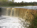 |
This is one of the greatest waterfalls in the Baltic States – 8 m high and up to 70 m wide. It is most impressive in the spring and after strong rains. The waterfall and its ~300 m canyon emerged from the limestone of the Ordovician Period. You may spot some fossils there. When the water is low, courageous people try to ford the river both above and below the waterfall. The limestone and the falling water have established a unique “tunnel” there.
|
|
|
|
Pamatīgs trīsstāvu koka tornis, no kura atklājas viens no labākajiem Matsalu līča un tā apkaimes palieņu pļavu skatiem, kuras apsaimnieko mājlopi, veidodami piemērotu vidi dažādām putnu un augu sugām. Laba migrējošo zosveidīgo putnu vērošanas vieta. Tā kā tornis ietilpst Tūlingu (Tuulingu) saimniecības teritorijā – spēkrats ir jāatstāj netālu esošajā autostāvlaukumā, bet suņi jāved piesieti kakla siksnā. |
|
 |
This is an entirely forested island in the Bay of Finland, ~14 km from Tallinn. A network of small pathways covers the entire island. Recommended hike along the seashore of the island, which will offer dunes, as well as a coastline that is sandy in some parts, rocky in others, and covered with reeds in still others (~9 km). A ferry boat will take you to the island from the Pirita port.
|
|
 |
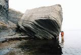
Der dritgrößte Feldstein im Baltikum (584 m3, 7 m hoch, Durchmesser bei dem Grund – 32 m ). Auf estnisch bedeutet „Hausstein”. Befindet sich am Rande des Pikanõmme – Majakivi Pfades (4,5 km lang). |
|
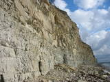 |
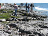
The highest and most beautiful wall of cliffs on Saaremaa Island (up to 21 m high), stretching along some 3 km. During strong winds from the W or NW, a part of the cliff is washed by the waves of the sea. The open face of the cliff has limestone, marls and dolomite, and there is a wealth of fossils at the base of the cliff – corals, stromatoporids, etc.
|
|
 |
This reserve dates back to Lake Ancilus, which was one of the original elements of what is now the Baltic Sea. The lake’s ancient shores feature wetlands, forests and flora which are all protected by the reserve.
|
|
|
|
Die zweitgrößte Insel Estlands mit breiter Waldung, Sand- und Steinstränden und einem der ältesten Leuchttürme Europas. |
|
 |
This park was set up to protect the landscape and cultural environment of the Haanja highland. At the central part of the park are the two highest hills in the Baltic States – Suur Munamägi, which stands 318 m above sea level, and Vällamägi, which is 304 m above sea level. The ancient Rõuge River valley (Rõuge ürgorg) is found in the western part of the park. It is 7.5 km long and up to 60 m deep. The valley dates back to the Ice Age, and it has seven lakes, including the deepest one (38 m) in Estonia – Lake Rõuge Suurjärv.
|
|
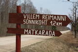 |
Kultūrvēsturiska taka (garums ~ 2 km) Tipu (Tipu) ciemā, kas iepazīstina ar vairākiem interesantiem objektiem: veco skolu (1931. g.), Hallistes upi, pirti un Paunas saimniecību, kurā dzimis viens no Igaunijas nacionālās kustības līderiem Villems Reimans (1861. – 1917.). |
|
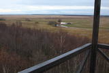 |
Suitsu tornis celts 1979. g. kā pirmais Matsalu rezervāta metāla tornis. To atjaunoja 1998. g. Torņa augstums ir 21 m, tādēļ no tā paveras izcila dabas un kultūrainava uz Kazari deltas niedrājiem un blakus esošo Suitsu upi (Suitsu jõgi), kuras krastā ir uzceltas vairākas zvejnieku laivu būdas. |
|
 |
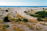
The national park was established to protect the 100 or so small islands that make up the archipelago of the local area. The largest island, the Vilsandi Island, is 6 km long and up to 2 km wide. You can rent a boat to get there, or, during appropriate conditions, you can walk across the sea and the small islands from the southern end of the Kuusnõmme peninsula.
|
|
 |
Vilsandi nacionālā parka „sirds” un divpadsmitā lielākā Igaunijas sala (garums - 6 km, platums – 2 km). Tā ir ļoti „jauna” sala, kas sākusi veidoties pirms ~ 2000 gadiem zemes garozas celšanās rezultātā, savienojoties divām salām, kas noticis pirms ~ 350 gadiem. Cilvēki salu sāka apdzīvot 18. gs. un to galvenā nodarbe bija zvejniecība, kuģu būve, nelielā apjomā – lauksaimniecība. Līdz 2. pasaules karam te bija ap 200 iedzīvotāju, kuri vēlāk salu bija spiesti pamest PRSR pierobežas režīma zonas dēļ. Nozīmīgu Vilsandi daļu aizņem mežs un kadiķu lauki. To visā garumā šķērso grantēts - zemes ceļš ar atzariem uz jūras krastu. Salu ar kājām var izstaigāt vairāku stundu laikā, iepazīstot vietējo apbūvi (daļa arī mūsdienās celtas ēkas) un Tolli sētu, kur pēc nostāstiem dzīvojis nīderlandiešu jūras braucējs Johans Dolls, kā arī vējdzirnavas. Noteikti ir jāaiziet līdz salas rietumu krastam, kur atrodas Vilsandi bāka un bākas uzrauga saimniecības ēkas. No šejienes ir labi redzamas Vaikas salas. Šodien uz salas pastāvīgi (visa gada garumā) dzīvo tikai trīs cilvēki. |
|
 |
Целью туристического центра Лахемаа является пропаганда природосберегающего образа жизни и умения жить в природе-сажаются деревья и развешиваются домики для птиц. Для интересующихся - походы на каноэ по Лахемааскому национальному парку, походы по болоту и стрельбу из лука и арбалета. Приятно провести время можно в каминном зале и сауне с гидромассажной ванной. |
|
 |
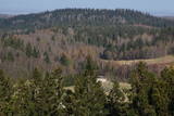
This is the first national park in Estonia and the Baltic States. Perfect for a day trip out from Tallinn for a hiking trip and nature watching. It was established in 1971 to protect the area that is along the Bay of Finland – the shoreline, forests, swamps, meadow biotopes, species, natural monuments, rocks, waterfalls, cliffs and cultural monuments such as ancient cemeteries, castle hills, baronial estates, fishing villages, etc. |
|
 |
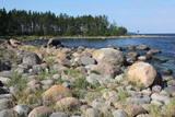
This is a “peripheral” island in the Bay of Finland, 9 km from the Dirhami port. The special fact about this island is that it offers fields of juniper, a rocky and grassy seashore that is around 2 km long, and limestone cliffs that are a few metres high along the northern and the eastern shores of the island. These are designated with the words Osmussaare pank.
|
|


