
| Нo | Название | Описание |
|---|---|---|
 |
Корчма Мульги находится в столице Мульгимаа в Абья-Палуоя, где вам предложат уютную обстановку, блюда мульги и приятное обслуживание. Корчма располагается в восстановленном 100-летнем доме. |
|
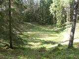 |
There are three craters here, and the biggest one, known locally as Põrguhaud, or Grave of Hell, has a diameter of 80 m and a depth of up to 12 m. There are barriers around the crater that are several metres high. The other two craters are hard to spot. The craters around 6,000 years old. No scraps of the supposed meteorite have been found, however, and so the origins of the craters cannot be confirmed with certainty.
|
|
 |
В хозяйстве из местных продуктов и без консервантов производят домашнее вино (фруктовое, ягодное, из цветов одуванчика), интересное варенье (пикантный сливовый соус и др.), фруктовые и ягодные консервы. Для туристических групп предлагаются экскурсии, дегустации и приобретение продукции. |
|
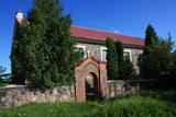 |
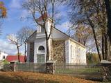
Находится в историческом центре Субате. Здание построено из валунов (без башен) в 1831 году на средства графа Михаила Зиберга – Платера. Перед храмом возвышается впечатляющая звонница. В церкви установлена скульптурная группа «Голгофа» конца 18 века, распятие и выразительный рельеф главного алтаря - резьба по дереву. Последний создан по мотивам знаменитой фрески Леонардо да Винчи «Тайная вечеря». |
|
 |
Autentiskā Zypliu muižas vidē izveidots restorāns. Kulinārais mantojums - Lietuvas muižniecības ēdieni. Ēdināšana, degustācija, izglītības programmas. |
|
 |
The forests of Zvārde are located on land which used to be a Soviet air base. The territory was unpopulated and was not accessible to civilians. The vast area includes various types of forest - boreal forest, bogs of black alder, etc. The fact that the military used to control the territory is one of the reasons why the forests of Zvārde are a location where many rare and protected birds live, reproduce and find food. Some of the elements of the old air base are still in place, including a unique surveillance platform. It is recommended that visitors to the area drive only along general use roads. |
|
 |
Небольшое населенное место со школой, библиотекой и магазином. К северу от Видале видны остатки ветряной мельницы. Направляясь в сторону Рижского морского залива, дорога пересекает обрыв Шлитерских Синих гор, откуда в безлиственный период открываются восхитительные виды и обнажения песчаника. Слева виден источник Синих гор - благоустроенное место для забора воды. Дорогу, ведущую из Видале в сторону Мелнсила, местные жители называют Клипелдамбой. Она, как будто бы была построена немецкой армией во время Первой мировой войны, устанавливая на дороге кругляки и засыпая их гравием. |
|
 |
Нагльский Римско-католический костёл Св. Иоанна Крестителя в 1862 году начал строить помещик Набелс. Нагльский
костёл изначально был филиалом Вилянского костёла, где слу-
жили бернардийские монахи этого костёла.
|
|
 |
This pyramid-shaped hillock with an observation tower at the top of it was established by the Soviet military. It is along the Ķevele-Saldus road, where the Zvārde airfield used to be located. It was used as an observation facility to co-ordinate army training manoeuvres. There is a view of the former airfield and the massive forests of the Zvārde Nature Park and nature reserve. It is an appropriate location for bird-watching. Note that there are no improvements there.
|
|
 |
Covered with rocks and with small capes and inlets, this is the eastern shore of the Bay of Rīga and the only place in Latvia where sandstone outcrops are found. These are the result of the abrasive effects of waves between Tūja and Vitrupe. Among the most distinguished of these outcrops are the Veczemi cliffs, which are less than half a kilometre long and up to four metres high. The area has been improved for tourists. It has to be said that this part of the shoreline changes very often, particularly after large storms.
|
|
 3 дня
|
The tour starts at Jaunmokas Castle estate, where you will also find the Forest Museum. The pride of the castle is its unique painted tile stove (beginning of the 20th century) made of 130 painted tiles featuring 50 different views of the cities Rīga and Jūrmala. The Forest Trails runs along smaller tracks through the Austrumkursa Uplands, the valley of the river Slocene, along Lake Sekļa and Lake Jumprava to finally reach the town of Tukums. Well, the town takes pride in its pots, planters and flower beds with blooming roses along its streets. Next, the route meanders through forests to the demanding hillock of Milzkalns and Lake Valguma, where you will find the barefoot trail and a secluded art space within the woods. The Forest Trail continues to make a stopover at the Ķemeri National Park. The park is dedicated to protection of wetlands, since it is home to one of the largest marshlands of Latvia – the Great Ķemeri bog. As to the town – Ķemeri – it is the former balneological and sulphur springs resort. The tour ends in the village of Bigauņciems, where the Forest Trail joins with the Baltic Coastal Hiking Route (E9 European long distance path). Optionally, one can take a detour along the Lake Sloka trail with its bird-watching tower or pay a visit to the “Forest House” – the visitor’s centre of the Ķemeri National Park. |
|
 |
Могила Менессмейтини Райниса (Иды Апсане) находится на старом лютеранском кладбище (в 0,2 км к северу от Лашской лютеранской церкви). На памятнике И. Апсане помещен следующий текст: «Ида Марие Aпсан род. 23 марта 1867 сконч. 10 апреля 1887». На Лашском кладбище захоронены и другие члены ее семьи.
|
|
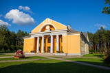 |
Один из необыкновенных городов Латвии, который как поселок торфяной фабрики образовался в 50 - 60 годах 20 века. Его планировали по «яркому» образцу советской архитектуры, с центральной площадью (с памятником вождя) и радиально уходящими улицами. Стоит увидеть Дом культуры (в конце улицы Узварас) - образец архитектуры сталинского классицизма. |
|
 |
Парк усадьбы Кретинга — один из старейших усадебных парков Литвы, сохранившихся с XVI–XVIII вв. Это парк смешанного стиля площадью 23 га. В южной части усадебного парка на месте бывшего фруктового сада установлен Астрономический календарь с солнечными часами, сформирована живая изгородь, проложены аллеи, разбиты клумбы, альпинарии, выращиваются коллекции георгинов, пионов, тюльпанов, восстанавливаются фрагменты розария, оборудованы пешеходные дорожки, места для отдыха. Отреставрированный фонтан усадьбы стал излюбленным местом для отдыха посетителей. |
|
 |
Благоустроенное искусственное водохранилище, вырытое в 60-е годы 20 века, чтобы получить лед для нужд Колкского рыбного завода. |
|
 |
Находится в центре Пиньки, на улице Ригас. Посвящен событиям 1919-го года, когда 22-го мая после почти двухмесячного бездействия бригада полковника Балодиса пошла в наступление на Ригу для освобождения столицы от большевиков. Поддержку бригаде Балодиса должны были оказать немецкий ландесвер и немецкая «Железная дивизия», а также отделение русского князя Ливена. Первый памятник был открыт президентом Латвии Карлисом Улманисом 23-го мая 1939-го года. В 1951-м году советская власть его уничтожила, а в 2003-м году была установлена копия памятника (скульптор Я. Бриедис, копия О. Скарайниса). |
|
 |
Городище Бусе (Маткулес) находится в изгибе берегов реки Имула. С него, на противоположный берег Имулы открывается один из самых живописных видов на речушки Курземе. Видом лучше всего любоваться в безлистный период, когда ландшафт не закрывает береговая растительность. В округе разбиты тропы для пеших прогулок. |
|
 |
Baltijā lielākās HES celtniecību uzsāka 1961. g., bet pabeidza 1966. g. Tajā uzstādīto 10 hidroagregātu projektētā jauda bija 825 MW. Pļaviņu HES tiek uzskatīta par unikālu, jo pirmoreiz HES būvniecības praksē tā konstrukcija tika balstīta uz mālsmilts un smilšmālu gruntīm ar maksimālo spiedienaugstumu - 40 m! Pļaviņu HES ēka ir apvienota ar ūdens pārgāzi, zem kuras atrodas Latvijas garākais tunelis - Enerģētiķu iela. 20. gs. deviņdesmitajos gados Pļaviņu HES rekonstruēja un tagad tās jauda ir sasniegusi 870 MW. Apmeklētāji var iepazīt mašīnzāli, skatu laukumus un HES maketu. |
|
 |
Kadarbiku estate is located in Harju, in the municipality Saue, in the village Tula (Tuula). Agriculture started to work here in 1989, while the family company Kadarbiku Köögivili OÜ was established in 2004. Kadarbik farms specializes in growing and processing vegetables. The farm uses 500 hectares of land, which grows carrots, cabbage, beets and various summer crops. They also make juices and smoothies. |
|
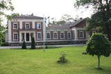 |
Atrodas Taurenē, Gaujas labajā krastā. Muižas apbūve, kurā ietilpst pils (19. gs. 80. gadi, arhitekts – R. G. Šmēlings, historisma un neoklasicisma stils), senie alus pagrabi, klēts, vecā pils un parks, veidojies 19. - 20. gs. Šobrīd muižas pilī atrodas Taurenes pagasta pārvalde un kultūras nams. Muižas kompleksā ietilpst ēka, kurā atrodas Vecpiebalgas novada tūrisma informācijas punkts un Taurenes novadpētniecības ekspozīcija (senajā ledus pagrabā). Parkā (ziemeļos no pils) uzmeklējams piemiņas akmens, kas veltīts komunistiskā terora upuriem. Pie Nēķena muižas sākās 0,4 km garā Cieres dabas taka, kas iepazīstina ar Gaujas krastu mitrājiem. |
|


