
| No | Name | Description |
|---|---|---|
 |
Bioloģiskā saimniecība nodarbojas ar Irbeņu ogu audzēšanu un dažādu to produktu ražošanā kā pulverus, sulas, tinktūras, eļļas, sejas maskas un kapsulas. Irbene ir vērtīgs ārstniecības augs, kur izmantojamas ir pilnīgi visas tā daļas – lapas, ogas, sēklas, stumbrs, miza, sakne un ziedi. |
|
 1 day
|
From Kaberneeme the route runs through a forest where you can see piles of stones carried here during the last ice-age. The trail soon climbs about 20 m up to the hiking trail, which runs on the old shore line of Lake Ancylus. The trail continues to the Linnamäe HES and a suspension bridge. Follow the trail over the ancient fortress hill of Linnamäe and continue on the right bank of the River Jägala, until reaching the Jägala waterfall. This is the highest natural waterfall in Estonia, more than 8 m high. The Suka bridge is about 500 metres up from the waterfall. After crossing the river, the trail passes through the Jägala waterfall park. Finally, the trail runs through the village of Koogi and arrives at Jõelähtme. |
|
 |
The farm offers visitors an excursion around the garden and wine cellars; it is possible to try wine, as well as buy wine, candy and marmalade. |
|
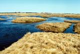 |
This is one of Estonia’s most beautiful karst fields, covering 125 hectares which feature different karst processes – subterranean streams, the dry Jõelähtme River bed, karst streams, funnels, ditches, caves, cliffs, a unique rock “mushroom,” etc. During the spring, the field is flooded, but at other times of the year, its contents are easily visible.
|
|
 |
Četrus kilometrus garā lokveida un marķētā dabas taka meklējama Plateļu pilsētiņas ziemeļaustrumu daļā. Tā ved pa dažādiem biotopiem – mežu, purvu, ezera malu, atklājot dažādas ainavas un tajās mītošās augu, putnu un dzīvnieku sugas. Šī ir interesantākā un ainaviskākā no Žemaitijas nacionālā parka takām. |
|
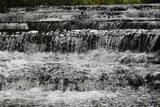 |
Krāčains Lobu upes (Loobu jõgi) posms pie Joaveski ciema, kur ~ 160 m garumā upes gultnē, tai šķērsojot Ziemeļigaunijas glintu, izveidojušās izmēros nelielas, tomēr ļoti ainaviskas un skaistas 0,5 – 1 m augstas ūdenskritumu kaskādes. 1898. g. šeit uzcēla hidroelektrostaciju, kuras atliekas ir redzamas upes labajā krastā. Iecienīta pavasara laivotāju treniņu vieta. |
|
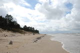 |
Бернати - самая западная точка суши Латвии. Рядом с автостоянкой установлен каменный знак скульптора Вилниса Титанса «Зеленый луч» (1998 г.). Бернатский мыс подвержен воздействию ветра и волн, поэтому здесь наблюдается вымывание морского берега. У дороги, которая из центра поселка Бернати ведет к морю, в конце дюн (имеется указатель), установлен памятный камень со словами первого Президента Латвии Яниса Чаксте, сказанными в 1924 году: «Здесь должен быть курорт». |
|
 |
No ģeogrāfiskā un kultūrvēsturiskā viedokļa interesanta teritorija Latgales augstienes Rāznavas paugurainē, kuras nozīmīgākie resursi ir dažāda veida biotopi, ainavas, reljefs un Šķaunes ezers. Istras pauguraines dabas parkā nav ar tūrismu saistīti labiekārtojumi, bet šo teritoriju var apskatīt arī „no malas”, braucot pa grantēto ceļu no Soboļinas uz Osinovku, kas iet līdztekus parka ziemeļu robežai (skats uz Šķaunes ezeru).
|
|
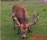 |
he wetland meadows that are around the Pededze River are the site of this 200 ha farm with some 350 red deer, other deer and wild boar. There are towers from which you can watch the graceful animals, and there are ponds for commercial fishing. Please contact the owner well in advance for a tour. |
|
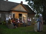 |
Latgalisko tradīciju un prasmju māja “Ambeļu skreine” ir latgalisko vērtību glabātāja un popularizētāja. Interesentiem tiek piedāvātas interaktīvas aktivitātes latgaliešu kultūras garā, dažādas meistarklases. “Ambeļu skreinē” tiek svinēti gadskārtu svētki un izkoptas dažādas amatu prasmes. Te notiek danču vakari, dziedāšana, zīlēšana, tiek cepta maizīte, siets siers un tiek veidotas tautas lietišķās mākslas izstādes. No mājas paveras brīnišķīgs skats uz Višķu ezeru un Latgales krāšņajām dabas ainavām. |
|
 |
The café is alongside the Top store in the centre of the village. Latvian cuisine: Potato pancakes with ham, grey peas with bacon, carrot buns. Special foods: The special “Apsīte” potted dish. |
|
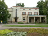 |
The building was erected during the first period of Latvian independence, and it maintained its functions for a long time. The building is located at Tukuma Street 30. Beginning in 1940, the post office had an automated telephone central. The Postal Service no longer uses it, and the building can only be viewed from the outside. |
|
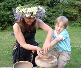 |
The craftswoman uses clay, rocks and other materials to produce dishware and various interior design objects, finishing them in an open kiln. Visitors can take an informational tour, watch the craftswoman at work, and sit down to produce their own cups. Guests are welcome to attend the opening of the kiln. |
|
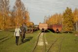 |
Sedas purva kājnieku maršruts atrodas dabas liegumā Sedas purvs, pārgājienu pa maršrutu iespējams apvienot ar Sedas pilsētas apskati, kas ir unikāls 20.gs. 50.–60. gadu pilsētbūvniecības un arhitektūras paraugs - kūdras purva strādnieku pilsēta. Maršrutam ir divi apļi - Jērcēnu aplis - 5,5 km un Sedas aplis - 4,2 km. Tajos apakatāms izstrādātais kūdras purvs, šaursliežu dzelzceļš, ritošais sastāvs, divi skatu toņi. Rudenī un pavasarī - putnu migrācijas lāikā - interesanta vieta putnu vērošanai. GPS koordinātes: Jērcēnu puses aplim: 57.7055987, 25.7001324; Sedas puses aplim: 57.6699587, 25.7514815. |
|
 |
This is a small river in a very deep and broad valley that is crossed by the Vecumnieki-Ilūkste road. Vilkupe was named in relation to the ambitious plan of Duke Jacob of Courland to link the river basins of the Daugava and the Lielupe rivers. Vilkupe was meant to be one of the components in this canal. This is a good place to think about the scope and innovation of Medieval people and their ideas. A fragment of the canal is marked and can be seen a bit less than 4 km from the populated location that is also called Vilkupe.
|
|
|
|
Vikmesti dēvē arī par Foreļstrautu, jo tā ir nozīmīga foreļu un taimiņu nārsta vieta. Gaujas labā krasta pieteka ir izveidojusi dziļu gravu ar stāvām nogāzēm, kuras lejtecē izveidojušies nelieli – ap 4 m augsti smilšakmens atsegumi. Gravas labajā (rietumu pusē) paceļas ar mežu apaugušais Vikmestes pilskalns. Gar Vikmestes upi izveidota taka, kuras sākumdaļa atrodas pie Siguldas – Turaidas ceļa, bet beigu daļa – pie Raganas – Turaidas ceļa (ap 3 km). |
|
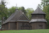 |
Die Kirche hat einen 1800 gebauten einzigartigen achteckigen Glockenturm. Blick auf den Lūšiai-See. |
|
|
|
This is a lovely place in Sigulda which has been painted (as the word "gleznotāji", which means "painters" suggests) and photographed for centuries. This is basically not a hill at all, it's just the place where the shore of the ancient Gauja River valley is split by the mighty Vējupīte ravine. You will have an excellent view of the Turaida Castle and the river valley. There are leisure facilities and a viewing platform there. You can ride to Paradīze hill via an electric car. |
|
 |
Café Pärnamäed is located near the highway Via Baltica 10 km from Pärnu, in the direction to Riga; it specialises in baking pastries, white bread and rye bread without preservatives, and also offers products from various small manufacturers. In the café you can also enjoy soups, main courses and desserts. |
|
 |
The owners have restored a fourth-generation bread oven to continue the tradition of baking bread. The family bakes bread in the autumn and winter months, from September to April. In the events organised by the Ventspils Seaside Museum they offer to taste traditional Latvian dishes that are in line with the rhythm of the seasons. |
|


