
| No | Name | Description |
|---|---|---|
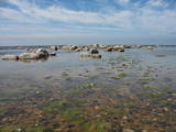 |
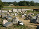
This is an important territory for the protection of reefs. It is opposite the Salacgrīva Administrative District and covers 3,577 hectares. The marine part of the “Rocky Shore of Vidzeme” nature reserve is a part of the territory.
|
|
 1 day
|
Dodieties ekskursijā, lai gūtu ieskatu lauku profesijā un dzīvesveidā, kā arī iegūtu jaunus iespaidus un labu atpūtu visai klasei. Ekskursijas laikā apskatiet iespaidīgākās un krāšņākās smilšakmens klintis Vidzemes piekrastē, kur viļņi ir izveidojuši līdz 6 m augstu stāvkrastu. Pēc tam apmeklējiet muzeja ekspozīciju, kura iepazīstina ar leģendārā fantasta un melu karaļa piedzīvojumiem un dzīves gaitām. Turpat netālu mežā izveidots vairākus km garš taku tīkls, un taku malās izvietotas dažādas koka skulptūras. Ekskursijas noslēgumā dodieties uz keramikas darbnīcu, lai uzzinātu, kā no māla top dažādi trauki un sadzīves priekšmeti, kā arī paši pamēģinātu roku kāda priekšmeta izvirpošanā. |
|
 |
The cafe is situated in the centre of Talsi. |
|
 |
The restaurant is situated in the centre of Rezekne city, alongside the Rēzekne University College in a building with vaulted cellars. The restaurant has an interesting interior design and its menu is developed according to the seasons of the year. Latvian cuisine: Cold soup, crepes, potato pancakes, roast pork, pork ribs, veal cakes, sautéed mutton, baked cod or trout. |
|
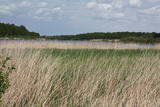 |
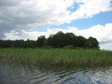
The main “treasure” in this restricted area is the shallow and eutrophic lake, which is home to many important birds. The lake and its flood-land meadows also feature many different plants. The Svētupe River flows from the northern part of the lake.
|
|
 |
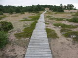
The Sunset trail starts in the centre of Saulkrasti town and takes you to the White Dune. Saulkrasti town with its municipal rural territory, occupies a 17km long stretch of coastal land to the North from the river Lilaste and the lake Lilaste. The White Dune stands on the right side of river Inčupe mouth. It is covered by old pine forest. The white, 18m high sand outcrop in olden times served as a landmark for fishermen. The White Dune formed as winds carried the sand from the beach over clay sediments of the Baltic Ice Lake. Some 150-200 years ago, the dune had been drifting as witnessed by several layers of soil buried within it. Local fishermen and farmers at Bātciems initiated afforestation of the drifting dunes. At that time, the 30m high dunes which are now covered with forest, were bare, shifting and even buried a farmstead. To speed up afforestation, mountain pines were planted. The White Dune was partly washed away in heavy storm in 1969, and 4-6m high precipice formed. Now the wind and sand have levelled out the dune surface, it has been fixed with willow-twigs or grown with forest where the largest pines are more than 170-190 years old. The pines are notable with their large trunks and branches, the scars obtained during their lifetime and the typical “crocodile skin” – the bark forms rhombuses resembling those of the reptile’s scales. Scots Pine (Pinus Silvestris) is one of the most common tree species in Latvia. It grows in dry, meagre sandy soil in dunes as well as in marsh. However, it does not stand overshadowing. Forest fires help pines to get rid of competitors as pine endures fire better than other trees because of its thick bark and high crown. The wood exudes resin and burned wounds close soon. Fire cleans space for seedlings of young pines. Pines can live 300-350 years. Ground cover in dune forests is very sensitive. If the sparse vegetation is destroyed, not only the natural biodiversity and landscape is damaged, but also the dangerous shifting dunes can possibly “wake up”. Embryonic dunes, White (yellow) dunes, Grey dunes and Wooded dunes are EU protected biotopes. Grey Dunes are protected by Latvian law as well. |
|
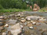 |
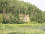
The Amata is one of Latvia's swiftest river, and water tourists congregate there each spring to engage in extreme activities. From the Rīga-Veclaicene highway, the Amata flows into a deep valley, with an average drop of more than 3 m/km or, downriver, as much as 8-10 m/km. Water tourists usually use the segment of the river between Melturi and the Zvārte cliff or the Veclauči bridge that spans the Līgatne-Kārļi road. Please remember that the Amata is not a friendly river for beginners. After lengthy rainfall, the river can be navigable during other times of the year, as well. The surrounding valley is attractive because of impressive sandstone and dolomite cliffs, among which the best known are the Vizuļi cliff (which can be the site of beautiful frozen waterfalls in winter), the Ainavu cliff, the Ķaubju cliff, the Dzilna cliff, the Zvārte cliff, and the Lustūzis cliff. Between Melturi and Veclauči, there is the Amata geological trail, which is marked with orange paint on tree trunks. There are three segments to the trail – from Melturi to the Kārļi fish farm, from the fish farm to the Zvārte cliff (both segments can be extreme!), and from the Zvārte cliff to the Veclauči bridge. You can hike the trail at any time except when there is deep snow. The most impressive views will be found when the trees are bare. If you boat down the river, you will not have time to look at or photograph the cliffs, because all of your attention will be focused on the river itself and the obstacles therein. |
|
 |
The craftsman produces gravestones, commemorative plaques and stone sculptures on the basis of orders from clients. He is prepared to tell you about a stonemason’s work and demonstrate his skills. |
|
 |
This museum was opened 1927 and is focused on the culture, literature, history, agriculture and technical history of the region of Anīkšči. Throughout the year, visitors are welcome to stroll through the park of the museum, which commemorates two distinguished Lithuanian authors. |
|
 |
Zemnieku saimniecība "Sprogas" ir Tīcu ģimenes dārzkopības uzņēmums, kura saknes veidojušās 90-to gadu sākumā, bet strauju attīstību tas ieguvis pēdējo desmit gadu laikā. Jau iepriekš "Sprogās" saimniekots ar vērienu – audzētas zemenes, narcises, lefkojas. Saimniecības vadītājs Ivars Tīcs darbošanās prieku dārzniecības jomā mantojis vairākās paaudzēs. "Sprogas" nodarbojas ar vasaras puķu stādu, augļu koku, dekoratīvo stādu, augļu un ogu audzēšanu. |
|
 |
Bērzes upes labajā krastā, vietā, kur tagad paceļas Dobeles pilsdrupas, jau 1. gadu tūkstotī p. m. ē. atradās zemgaļu apmetne un vēlāk – koka pils. Gandrīz simts gadus pils izturēja vairākus krustnešu uzbrukumus un aplenkumus, un tikai 1289. g., kad vācieši bija pilnībā izpostījuši apvidu un tālāka pretošanās kļuva bezcerīga, zemgaļi paši nodedzināja savu koka pili un neuzvarēti aizgāja uz Lietuvu. 700 gadus vēlāk, 1989. gadā, godinot zemgaļu cilšu piemiņu, bijušās senpilsētas vietā tika atklāta piemiņas zīme, ko veidojis mākslinieks Mārtiņš Zaurs. Akmenī iecirsts teksts: “Zini, no šīs vietas pirms 700 gadiem zemgaļi aizgāja lepni un brīvi”, kā arī dzejnieka Viļa Plūdoņa vārdi : “Mēs svešā malā ejam, bet sirds mums paliek te”. |
|
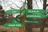 |
is seen as the newest village along the Livonian coastline. It was established during the 17th century. Košrags had 78 residents in 1826. The first reading school for Livonian children in the Dundaga seashore villages was opened at the Žoki homestead in 1832. One of the teachers was Nika Polmanis, who was the first Livonian to have completed a professional education. He also translated the Gospel of Matthew into the Eastern Livonian dialect. Košrags had a windmill, water mill and boat building facility. During the spring, job seekers from Saaremaa stopped here. A port was installed in 1932, and a breakwater to collect sea fertiliser followed in 1938. During the 1930s, Košrags was regularly visited by Finnish and Estonian linguists to study the folklore of the Livonians. The Norpiedagi homestead was built by Livonian activist Didriķis Volganskis (1884-1968). His son, Livonian cultural worker and pastor (in Finland) Edgars Vālgamā (Volganskis, 1912-2003) was born there. He translated the Andrejs Pumpurs epic "Lāčplēsis" into Finnish. Košrags today is a cultural monument of national importance. |
|
 |
Pussalas pils pirmsākumi ir meklējami 14. gs. Tajā laikā minētā pils bija viena no lielākajām šāda tipa aizsardzības pilīm. Pēc Traķu un Viļņas ieņemšanas 1382. g. pils kļuva par Ķēstutu (Kęstutis) - Lietuvas dižkunigaišu dzimtas dzīves un valdīšanas vietu. 1655. g. Polijas – Lietuvas lielvalsts un Krievijas kara laikā pili nopostīja. Līdz mūsdienām no iespaidīgās celtnes (aizņēma 4 ha platību) saglabājušās tikai no laukakmeņiem celtā aizsargmūra un torņu paliekas. Tās iekšpagalmā ir apskatāma efektīvā viduslaiku ieroča – katapultas atdarinājums. |
|
 |
Elkas kalna saimniecība is located on the top of the scenic Elkas Hill, the place where the Gauja begins. Herbal teas, birch sap, jams and other healthy delicacies from local meadows and home-grown plants. There are also nature workshops, open-air picnic areas. |
|
 |
Of the many islands in Lake Rušons, ten are restricted natural areas so as to protect the broadleaf forests which are on the islands and the endangered plants found therein. An ancient cult location – the Rušons Sacrificial Rock – is found on Upursala island.
|
|
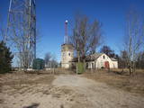 |
This military object ensured radio communications. Now the facility is owned by the Latvian Defence Ministry, and it can only be viewed from the outside.
|
|
 |
One of the most beautiful areas along the Venta River and its tributary, the Šķērvelis River. The river valleys and gullies along them are quite deep, and dolomite and sandstone cliffs can be spotted here and there. There are also rapids on the river. The largest cliffs in Kurzeme – the Ātraiskalns and Gobdziņi cliffs – can be seen on the banks of the Venta. The Lēni Catholic Church is near the restricted area. There are no tourist elements in the restricted territory at this time. The Venta is a popular destination for water tourists, however, from Nīgrande to Kuldīga. |
|
 |
Igaunijas jūras ūdeņos ir saskaitīta 1521 sala! Salu sarakstā pēc platības (63 ha) ~ 2,5 km garā Mohni sala ieņem 38. vietu. Lai saudzētu salas trauslo veģetāciju (vietām nedaudz atgādina krūmainu tundru), tās vidusdaļā ir izveidotas koka laipas. Salas dienviddaļā atrodas sašaurinājums, kuru tāpat kā blakus esošo jūras krastu klāj viens no savdabīgākajiem Igaunijas akmeņu laukiem. Salas ziemeļos esošās Mohni bākas (Mohni tuletorn) celtniecība pabeigta 1871. g. un tās gaisma ir redzama 10 jūras jūdžu attālumā. Šī ir viena no skaistākajām Ziemeļigaunijas bākām! Līdz Mohni salai var nokļūt ar laivu (iepriekšēja pieteikšanās) no ~ 5 km attālās Vīnistu ostas (Viinistu sadam). Ar jūras laivu vai kajaku piemērotos apstākļos būs ~ 1h ilgs brauciens. Jārēķinās, ka uz salas nav pastāvīgo iedzīvotāju! Vīnistu ciemā apskatāms 2002. g. izveidotais Vīnistu mākslas muzejs (Viinistu kunstimuuseum). Apmeklētājus iespaidos ne tikai tā āriene, bet arī tapšanas vēsture. |
|
 |
Netālu no augstākā Latgales augstienes paugura – Lielā Liepukalna atrodas zemnieku saimniecība, kuras darbnīcā amatnieks Jānis Kuzminskis taisa mūsdienīgas ģitāras u.c. mūzikas instrumentus. Apmeklētāji var iepazīt Jāņa veidoto ekspozīciju, vērot amatnieka darbošanos, pasūtīt sev jaunu instrumentu, kā arī muzicēt pie bagātīgajā kolekcijā savāktajiem instrumentiem. Saimniece stāsta par Latgales kulinārā mantojuma ēdieniem un rāda, kā gatavo gulbešnīkus. |
|
 |
The owner is a sauna master, healer, masseur and Reiki master who is interested in ethnic culture and offers guests real leisure and health improvements that have been tested by his ancestors -- sauna programmes, the secrets of medicinal plants, restoration of links to nature, as well as entertainments on the water. |
|


