
| No | Name | Description |
|---|---|---|
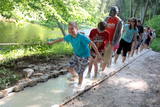 |
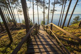
The first barefoot trail created in the Baltic States in the recreation complex "Valguma pasaule", which is located on the forested shores of Lake Valguma. When walking on the path, the feet "massage" sand, wood chips, clay, peat, gravel, cones and various other materials. |
|
 |
Nepilnus 3 km garā taka iepazīstina ar dziļo Imulas ieleju – Abavas kreisā krasta pieteku. Īpaši iespaidīga ieleja izskatās bezlapu periodā, kad ir apjaušami tās izmēri un formas. Viens no takas iespaidīgākajiem objektiem ir Buses jeb Matkules pilskalns. Apskatāmi citi objekti – Baznīckalns, Bedrīšakmens, Ķauķa kalns ar avotiņu. Atrodas dabas parkā „Abavas senleja”. |
|
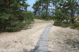 |
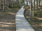
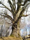
The trail (the length 1.2 km) introduces with the habitats of dunes and century-old pines, partly covered with sand. Biologists estimate that the oldest tree, the “mother of pines”, could be around 200 years old. Coastal pine forests serve as a barrier between the sea and land protecting inland areas from impact of the sea and winds. Felling coastal forests was forbidden by law already back in 1643, during the Duchy of Courland. Still due to economic activities, the seashore forests were often fell and fires occurred there occasionally. As a result, the sand which had for centuries been hold by trees, started drifting at Cape Kolka. In the 1930ies, there were about 142 hectares of sandy areas in the Slītere National Park, and 11.5 hectares of those were drifting sand. To stop drifting, the sand areas were carefully afforested. Afforestation was started before WW I and it was completed in the 1970ies. To plant new trees, first the sand had to be stopped. Just 26km to the south from Kolka there was one of the largest sand dunes in Latvia, 25km in length. Every year it devoured 0.3 hectares of land. The sand was stopped covering it with heather, twigs and branches of pines and junipers. Pine trees were planted between them. Today in Kolka, the old, low pine trees tell about the once drifting sand. After storms, when the water washes the bluff and tree roots are exposed, one can see that the tree trunks once have been covered with sand more than 1 meter high. The trees on the seacoast usually have crooked trunks and flag-shaped crowns formed under influence of persisting sea winds. Now these forests are designated biotope “Wooded dunes of the coast”. Stable white dunes (biotope 2120) do not form in Cape Kolka as they are washed by sea waters during spring and autumn storms. Embryonic dunes develop here (code 2120) with plants that usually grow in dunes. These plants have adapted well to poor soils, heat, drought, and the saline sea water. The Kolkasrags Pine Trail is in Slītere National Park. |
|
|
|
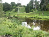
Located at the Lake Burtnieks southern shore, these are wetland meadows which are regularly flooded and which are important places for various birds, including the corn - crake, to nest. This is part on the environmentallyrestricted area which covers the meadows of Lake Burtnieks. |
|
|
|
Ap 7 km garā apļveida taka sākas pie leģendārajām Mangaļu mājām. Tā iepazīstina ar latviešu strēlnieku kauju vietām, vietām, kur atradušās to fortifikācijas, t.s. „Vācu valni” u.c. liecībām. Mangaļu mājās – Ziemassvētku kaujām veltīts muzejs. |
|
 |
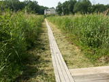
This wooden pathway will introduce the visitor to a high-type swamp and a unique habitat – a place where sulphur streams flow into the Raganu swamp. The little lakes in the swamp are unique – they are the result of sulphur bacteria, and there is a special range of species in those lakes. The landscape is interesting, and the smell of sulphur pervades, mostly from sulphur ponds. The trail is 800m long and will require 20 minutes to an hour to traverse. The object is on the border of the Zemgale and Vidzeme regions.
|
|
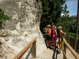 |
In terms of shape, this is one of the most diverse areas of uncovered sandstone in Latvia. Found on the right bank of the Gauja river, the Sietiņiezis is up to 15m high. Small holes that can be seen in the cliff face are created by single and protected insects, which carve tiny caves in the cliff for their caterpillars. A circular and well appointed trail, with stairs, has been installed. It is 1.5 km in length and will take an hour or so to traverse. Objects are in the Gauja National Park.
|
|
 | ||
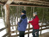 |
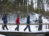
Lots of wild animals can be found in vast paddocks along the ancient Gauja river valley and its small tributaries – areas in which living conditions are as close to natural circumstances as possible. Here the visitor can find, if lucky, reindeer, deer, wild boars, bears, foxes, lynx, various kinds of birds, as well as aurochs. There is a dense network of pathways in the park, including lots of information. There is also a route for drivers and bicyclists. During the winter, it is used for distance skiing. There is also a visitors’ centre.
|
|
 |
The beginning of this circular trail can be found at the Krimulda church – the oldest in Latvia. In one direction, the tourist will pass along the banks of the little Runtiņupīte river (Runtiņš) to the place where it flows into the Gauja river. Among the points of interest along the way are the parsonage of the church, the Kubesele castle hill, a memorial to the Livonian chieftain Kaupo, the Kubesele cave, the Saulstari rock, the “Great Rock”, ancient anchor blocks, ancient graveyards, a unique labyrinth, etc.
|
|
 |
Interesanta dabas izziņas taka, kurā izvietoti informatīvie stendi, kas stāsta par dažādiem pļavu biotopiem – sausām, palieņu un parkveida ozolu pļavām un tās iemītniekiem. Pļavas nogana dzīvei savvaļā pielāgotie mājlopi. |
|
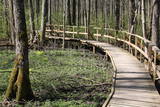 |
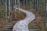
Uz pāļiem veidotā koku laipu taka līkumo cauri Vēršupītes dumbrājiem (pārmitri platlapju meži), tādēļ visiespaidīgākie skati šeit ir vērojami tieši pavasara palos vai citos gadalaikos pēc lielām lietavām, kad mazā upīte iziet no krastiem un appludina dumbrājus lielākā platībā. Par teritorijas sezonālu applūšanu liecina arī daudzo alkšņu resnie sakņu kakli, kas nevilšus atgādina mangrovju audzes. Mitrie meži ir viens no sugu skaita ziņā daudzveidīgākajiem Latvijas biotopiem.
|
|
 |
This is a fairly unique territory in Latvia – a vast forest of oak trees (many of them very large, indeed), linden trees, elms and various other deciduous trees. In the company of a forest guide, the visitor can walk through a small part of the forest, learning about the inhabitants of the area and their importance. This is an environmentally protected zone.
|
|
 |
Plieņciema taka atrodas dabas liegumā "Plieņciema kāpa" starp Plieņciemu un Ķesterciemu. Pāri kāpai ir izveidota laipu taka un atpūtas vieta. Taka ir izveidota, lai mazinātu negatīvo ietekme uz Plieņciema kāpas dabas vērtībām – zemsedzes nomīdīšanu, piegružošanu ar atkritumiem, braukšanu ar autotransportu.
|
|
|
|
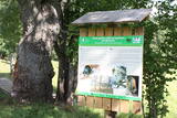
This trail offers education about the forest for children of all ages, families with children, and friends of the environment. The trail is located in the Īle Parish of the Auce Administrative District, 2 km from the Pokaiņu forest. |
|
 |
One of the few places in Latvia where there are so many well-organised pathways. The region is known for castle hills, the location where the great Latvian author Anna Brigadere (1861-1933) lived and worked, the storybook character figures that are scattered around that area, a great forest, an arboretum, a museum of history, a viewing tower, landscapes, etc. This has been recognised as the most family-friendly place in the country.
|
|
 |
Taka veidota gar Gaujas labo krastu augšpus un lejpus Gaujienas un tā iepazīstina ar nogāžu mežu un dažādu pļavu biotopiem. Visā tās garumā izvietoti informatīvi stendi. Takas daļu lejpus Gaujienas var braukt ar velosipēdu.
|
|
 |
The trail reveals one of the rare bluffs of the Gulf of Riga – the Ēvaži Bluff (up to 15m high, a beautiful scenery opens from its watching platform) and the seashore forests. The trail starts from the main road and crosses a biotope “Wooded dunes of the coast” (according to Habitats Directive, Annex II), which is frequently observed by the sea. One can climb down the stairs to an extraordinary beach with narrow seashore and Black Alders growing almost in the sea. There are occasional puddles which make shelter for Natterjack Toad (Bufo calamita), a protected amphibian. Deeper pools are inhabited by three-spined stickleback (Gasterosteus aculeatus), they are food for fish-eating birds. In the second half of the summer, Common Shelduck (Tadorna tadorna) can be observed in the sea. About two kilometres to the South, there is Melnsils, one of the Liv fishing villages, famous for the stories about a channel which was once dug to drain coastal lakes into the sea, as well as about Trommel, the chief of robbers. The trail is in the Slītere National Park. |
|
 |
Near the Lielauce manor house start of a wooden pathway which crosses the transition-type swamp that is on the shore of Lake Lielauce to a boating facility near the open part of the lake. Boating and fishing are possible – here, too, the population of fish is regularly restored. The area is a part of the Vīķi swamp restricted zone. |
|
 |
Aptuveni 2km garā Ķirbižu meža izziņas taka izveidota apļveidā gar Vitrupes abiem krastiem. Visā takas garumā var mācīties atpazīt Latvijas mežu raksturīgākos kokus, krūmus un augus. Šeit var aplūkot arī Vālodzes dižozolu (6.5 m). Upes labajā krastā, pie tā sauktā vīna pagrabiņa un kreisajā krastā apmēram 200 m no takas sākuma pie Meža muzeja, atklājas ainaviski skati uz ieleju un Vitrupi. |
|
