
| No | Name | Description |
|---|---|---|
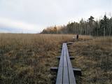 |
Taka atrodas Riekstusalas pussalā, netālu no putnu vērošanas torņa. Uz peldošiem pontoniem celtā laipa iepazīstina ar Kaņiera ezeru „tuvplānā”. Var iepazīt niedrājus, to putnus, labi redzamo ezera gultni ar zivju mazuļiem un kalcifilām augu sabiedrībām. Laipa aizved līdz salai, uz kuras aug kadiķi. |
|
 |
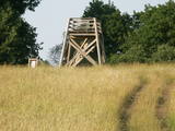
This is a trail for hikers and bird-watchers, located in a very interesting place on the shore of the Bay of Rīga near Kaltene. The visitor will see small inlets and capes and a rocky or overgrown shore. At the end of the trail there is a bird-watching tower. During the spring and autumn migrations of birds, the visitor will see a great many different kinds of birds in the area – geese, plovers, etc. The length of the track is a bit more than one kilometre, and it will take 20 minutes to an hour to cover.
|
|
 |
Near the Priedīši homestead, there is a nature trail which allows visitors to study Lake Dziļezers and the surroundings. There are various lakes in this region which are found in a depression left behind by the Ice Age – Lake Dziļezers, Lake Riebezers, Lake Mazezers, Lake Auziņš, Lake Skuja and Lake Bruņķītis are all there. Along their shores, there are various kinds of forests, including ones with broadleaf trees that are under environmental protection. The trail is 3km in length and will take an hour or so to traverse. This is a part of the environmentally restricted territory of Lake Dziļezers and Lake Riebezers.
|
|
 |
Taka izveidota Limbažu Lielezera ZA galā, tā ir 3.6 km gara vienā virzienā. Ezeru ziemeļu galā izbūvēts putnu novērošanas tornis. Izbūvēts bērnu rotaļu laukums, labiekārtotas atpūtas vietas, izveidota laivu piestātne. Pāri Donaviņai izveidots gājēju tiltiņš uz pontoniem. |
|
|
|
Vikmesti dēvē arī par Foreļstrautu, jo tā ir nozīmīga foreļu un taimiņu nārsta vieta. Gaujas labā krasta pieteka ir izveidojusi dziļu gravu ar stāvām nogāzēm, kuras lejtecē izveidojušies nelieli – ap 4 m augsti smilšakmens atsegumi. Gravas labajā (rietumu pusē) paceļas ar mežu apaugušais Vikmestes pilskalns. Gar Vikmestes upi izveidota taka, kuras sākumdaļa atrodas pie Siguldas – Turaidas ceļa, bet beigu daļa – pie Raganas – Turaidas ceļa (ap 3 km). |
|
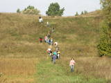 |
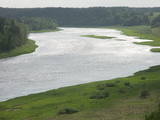
The Markova information trail is the most diverse and impressive trails along the upper reaches of the Daugava river in terms of objects and landscapes. The visitor will go to the top of the Markova castle hill, which offers a great view of the river valley. The deep Putāni stream valley will be crossed to get to the cliffs on the right bank of the Daugava. Here, the visitor will see one of the most unusual landscapes of Latvia’s river valleys. There is the Slutišķi village of Old Believers, along with the mighty Slutišķi cliff in the background. The trail is 1.6km long, and it will take an hour or two, particularly if the visitor chooses to tour the village and the homes of the Old Believers.
|
|
 |
Cecīļu dabas taka ir kājāmgājēju tūrisma maršruts, kurā ir iespēja iepazīt Amatas novada dabas objektus gar Kumadas upes, Dančupītes un Amatas upes krastu. Takas sākuma punkts ir Amatas novada Ieriķos, 1 km no kafejnīcas, degvielas uzpildes stacijas, Cecīļu dabas takas apmeklētāju centra, blakus autoservisam. Apmeklētājiem ir iespēja izbaudīt cilvēka nepārveidotu dabas ainavu – Dančupītes kanjonu, minatūru ūdenskritumu, no Kumadas upes labā krasta aplūkot iespaidīgo Cecīļu iezi un citus objektus. Taka ir marķēta. |
|
 |
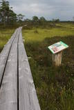
This wooden pathway will introduce the visitor to a high-type swamp and a unique habitat – a place where sulphur streams flow into the Raganu swamp. The little lakes in the swamp are unique – they are the result of sulphur bacteria, and there is a special range of species in those lakes. The landscape is interesting, and the smell of sulphur pervades, mostly from sulphur ponds. The trail is 800m long and will require 20 minutes to an hour to traverse. The object is on the border of the Zemgale and Vidzeme regions.
|
|
 |
Interesanta dabas izziņas taka, kurā izvietoti informatīvie stendi, kas stāsta par dažādiem pļavu biotopiem – sausām, palieņu un parkveida ozolu pļavām un tās iemītniekiem. Pļavas nogana dzīvei savvaļā pielāgotie mājlopi. |
|
|
|
Located at the Lake Burtnieks southern shore, these are wetland meadows which are regularly flooded and which are important places for various birds, including the corn - crake, to nest. This is part on the environmentallyrestricted area which covers the meadows of Lake Burtnieks. |
|
 |
This circular trail features a unique landscape of parallel rampart-type sand dunes and grassy swamps among the dunes. The 3.5 km trail leads through a landscape that is unique in Europe and emerged some 6,000 years ago as the sea was receding. This landscape offers evidence of the geological history of the Baltic Sea. There is a high-type swamp (the Pēterzers swamp), along with remnants of an old narrow-gauge railway. Wooden pathways have been installed along the swamp and the surrounding wetlands. |
|
 |
Folkloras taka "Jāņkalni" iepazīstina ar mūsu senču rakstiem, zīmēm un dievībām, kas ir mūsu folkloras mantojums. Folkloras takas (garums: apm. 1,5 km vai 2 stundas) mērķis ir arī iepazīstināšana ar senlatviešu ieražām, folkloru, kā arī tautu dainu izprašana. Piedāvā iziet Latvijas karti - labirintu ar 19 etnogrāfiskajiem novadiem. Gids Jums sniegs izsmeļošu stāstījumu un atbildes uz interesējošiem jautājumiem.
|
|
 |
The Dinaburga trail first goes downhill, and then it quickly goes uphill to the steep shores of the Daugava river. Among a set of gullies, there is the Naujene (Vecpils) castle hill – some 25m high and the “cradle” of the city of Daugavpils. The ruins of the castle are still visible, and a unique open-air model of the old Dinaburga castle has been prepared. There is a lovely view of the Daugava river valley, and the visitor can expect to spend 20 minutes to an hour here. Objects are located in a protected area of Augšzeme landscapes and in the Curves of Daugava nature park.
|
|
 |
Here the visitor will find an ecological tourism trail in the ancient Embūte valley. The hills around Embūte date back to the Ice Age. There are valleys and forests of many fallen trees which are protected habitats. The visitor will learn about important natural and cultural monuments – the Embūte castle hill, as well as the ruins of a baronial estate, a castle and a church. The Courlandian chieftain Indulis died in the region. The visitor can view the Devil’s Dam, along with meadows, a viewing tower, etc. There are bicycler routes in the region. The site is located in the Embūte nature park. |
|
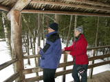 |
Lots of wild animals can be found in vast paddocks along the ancient Gauja river valley and its small tributaries – areas in which living conditions are as close to natural circumstances as possible. Here the visitor can find, if lucky, reindeer, deer, wild boars, bears, foxes, lynx, various kinds of birds, as well as aurochs. There is a dense network of pathways in the park, including lots of information. There is also a route for drivers and bicyclists. During the winter, it is used for distance skiing. There is also a visitors’ centre.
|
|
|
|
Andrupenes dabas takā var iepazīt sūnas, pārliecināties par sfagnu lielo ūdens uzsūkšanas spēju, gar laipas malām ieraudzīt apaļlapu raseni un purva dzērveni, apskatīt spilves, vaivariņus un purva vārnkāju, kā arī purva pasauli. Takas garums ~ 750m.
|
|
|
|
A marked hiking route (a guide will be needed) begins at the Jēči windmill, which was built in 1878. Nearby is a dendrology park and a collection of rocks. You will learn about moraines and other geological features in the region, study various kinds of swamps, see the unique piles of rock at Pugas, as well as the Kraujiņi rock. The route is 7 or 5 km in length, returning at the starting point, and it will take some four hours to traverse. Be sure to put on waterproof boots!
|
|
 |
The trail informs visitors about one of the loveliest natural habitats in
|
|
 |
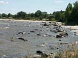
Nature trail "Curves of Riva" starts at Ulmale-Labraga Lutheran Church and continues 3 kilometres down the picturesque downstream of river Riva. Rīva here flows in a canyon-type ravine which reaches 12 meter rise at some points. The trail reveals countless river twists and turns and steep coastal cliffs. The trail is partly accessible with an assistant and is marked with green paint. |
|
|
|
10 km garais pārgājienu maršruts iepazīstina ar vienu no vēl retajiem, cilvēka mazāk ietekmētajiem Daugavas senlejas posmiem. Tā sākums – Aizkraukle, finišs – Skrīveri. Gar upes krastu izvietotas atpūtas vietas. Maršrutu var braukt arī ar velosipēdu. |
|
