
| No | Name | Description |
|---|---|---|
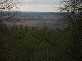 |
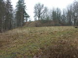
This is an area that is full of legend and tale. There is a stiff hillock, which stands about 66 metres above the surrounding land. From its southern side, you can see the Burtnieki lowlands. The tower, however, is not open to the public.
|
|
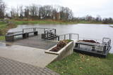 |
Gar Grobiņas ūdenskrātuvi (Ālandes labais krasts) izveidota mūsdienīga un labiekārtota pastaigu un atpūtas vieta - promenāde, uz kuras izvietotas plāksnes ar Zentas Mauriņas un Jāņa Raiņa citātiem. No promenādes paveras labi skatu punkti uz Skābaržkalnu un Grobiņas pilsdrupām. Grobiņas ūdenskrātuves sašaurinājumā pāri Ālandei ved neliels tiltiņš, kas ir bijušā Liepājas – Aizputes šaursliežu dzelzceļa tilta ferma. |
|
 |
On the left bank of the Gauja River, opposite the Piķene cliff is the mighty Beite cliff which is split by a deep ravine. On the left side there is Ķeizarskats (Emperor's View), which is approximately 67 metres above the level of the Gauja and offers a fine view of Krimulda and the Turaida Castle. The viewing place was installed in 1862, when Russian Tsar Alexander II visited Sigulda. On the right side of the ravine is the mighty wooden Ķeizarkrēsls (Emperor's Chair). To get there, you have to cross the ravine (there are wooden stairs and a forest trail). You can go around it on Laurenču, Kalna and Gulbju streets. |
|
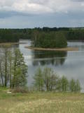 |
In Vecslabada, there is a peninsula among Lake Dziļezers, Lake Audzeļi, and Lake Istra. From the highest point on the peninsula, you will see a truly unusual view of the land of the blue lakes – lake islands, as well as the village of Vecslabada with its church towers. The Lake Istra nature reserve is nearby.
|
|
 |
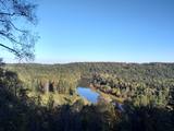
This is not a well known castle hill, but it offers one of the most unusual views of Lake Lielezers of Augstroze. There are ruins on the castle hill, and a short hiking trail has been installed to look at them. This is part of the ZBR.
|
|
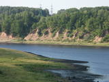 |
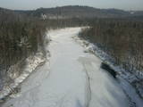
In Aizkraukle, drive down Enerģētiķu Street to the Selonian side (there will be small “pockets” at the side of the road) to see one of the best views of the Daugava River valley, reminding us of what this fateful river was like before the power plant was built. You will see that the river has eroded the steep cliffs on the right bank. The further part of the valley is part of the Daugava Nature Park.
|
|
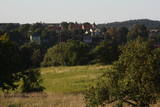 |
The hill is the highest point on the shores of the little Slocene River valley, and it is located in Tukums, at the side of Jelgavas Street. It opens up a broad view of the Slocene River valley and the town of Tukums with its historical centre on the opposite side of the valley. The view is particularly interesting in the evening, when the town is lit up. There is a monument to the liberators of Tukums.
|
|
 |
The barrow which offers a good view is at the northern end of the Dunduri meadows – at the end of Melnragi. It is an artificial barrow which follows along with the bed of the little Slampe River. The meadows are home to livestock allowed to live in the wild, and you can see a bit of the restored Slampe. The view is particularly interesting during flooding season, when the surrounding wetlands become saturated. This is a location for bird-watching.
|
|
 |
The Buse (Matkule) castle hill is near the Imula River. From the castle hill and from the opposite shore of the river, you can find one of the loveliest views of Kurzeme’s small rivers. Their appearance is best when trees and other flora are bare and the view is unimpeded. A wonderful view of the Imula valley is also seen on the road to the castle hill – near the Buse homestead.
|
|
 |
Daugavas aizsargdambju būvniecību Jēkabpilī uzsāka pēc 1981. gada lielajiem paliem, kad ūdens līmenis pārsniedza kritisko - 6,3 m atzīmi un pakāpās līdz rādījumam „8,7 metri”. Šo plūdu laikā puse pilsētas klāja Daugavas ūdeņi. 2011. gada vasarā notika plašāki dambja atjaunošanas un labiekārtošanas darbi. Pie tā uzstādīja laternas, soliņus, izveidoja pastaigu promenādi un piemiņas zīmi Daugavas kreisajā krastā, kas parāda maksimālo plūdu līmeni. Uz aizsargdambja Daugavas labajā krastā ir izvietoti informatīvie stendi, kur var uzzināt daudz interesantus faktus par pilsētas vēsturi. Dambji ir piemērota vieta, kur fotografēt vai gleznot pilsētas ainavas. |
|
 |
This is a view worth a journey from a distance. This is an impressive terrain for Latvia, and here you will see as far as the Hanja highlands of Estonia, where the Great Munameģis Hill – the highest surface in the Baltic States – can be found.
|
|
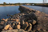 |
Molu (sākotnēji – pāļu rindas ar akmeņu krāvumiem) izbūve pie Sakas ietekas jūrā tika uzsākta 1878. gadā, lai nodrošinātu ostas darbību. 1929. gadā notiek molu pārbūve, pagarinot tos ar masīviem betona blokiem. Pēdējā rekonstrukcija notika 2010. gadā, pārveidojot molus par ērtu pastaigu un makšķerēšanas vietu, no kuras var vērot arī saulrietu. |
|
 |
The flat surface of this large hillock (247 m above sea level, ~60 m above the surrounding area) offers one of the most beautiful landscapes in Latgale, complete with Lake Rāzna. During the 13th century, the Livonian Order built the Volkenberga Castle on the hillock, and it was thought to be practically impenetrable. Fragments of the castle’s walls remain visible today. |
|
 |
In the centre of Līgatne, on the right bank on the rapid Līgatne River, there is a viewing plan which offers a close-up look at one of the most impressive sandstone cliffs which rise above it – the Lustūzis cliff. There are artificial caves in the wall of the cliff, which locals use as cellars and as places to store their property.
|
|
 |
From the highest point in the Alūksne highlands, you will see an unusually beautiful view of the surrounding forested hillocks and the small areas of meadows and farmland. Sadly, there are no improvements to the location, which can be difficult to access. It is on private property.
|
|
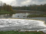 |
The recently renovated old brick bridge and the viewing area that is on the left bank of the Venta beyond the castle guard’s hut offers a lovely view of the widest and most impressive waterfall in Latvia – the Venta falls. It is worth visiting during the spring floods, when fish are migrating.
|
|
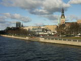 |
The classical skyline of Old Rīga can be enjoyed from several locations – Mūkusalas Street, between the railroad bridge and the stone bridge, from the stone bridge, from the A-B dam, from the grounds of the central office of the Swedbank bank, from the Vanšu bridge, and from the Ballast Dam at Ķīpsala. You can hike or bike from location to location. During the summer, little ships cruise up and down the Daugava to offer different views.
|
|
 |
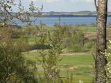
The impressive Gauja River valley and its best natural and cultural landscapes can be seen from Paradīze (Gleznotāji) Hill, the Sigulda castle ruins, the aerial tram, the Ferris wheel, the Ziediņi and Pilsēta ski trails, the area of the bobsled and sledding trail, Ķeizarskats, the viewing area of the Velnala cliffs, the mountain bike route of Sigulda (on the right bank of the Gauja, particularly when the trees are bare), the area of the Krimulda castle ruins, Dainu Hill, and the Turaida castle tower.
|
|
