
| No | Name | Description |
|---|---|---|
 |
This is an ancient Liv village, known as Mustanumm is the last village in the south-easterly direction, and during the mid-20th century, just a few Livonians lived there. Of 307 inhabitants in 1935, only 15 were Livonians. At the beginning of the 19th century, there were six farms and a lagoon here, but at the end of the century there were 63 farms. The valley of the Baķupīte River and the sea had remnants of pilings that provided evidence about a Medieval port. Legends say that the sea robber Trommel had a castle on the left bank of the river during the 14th century. Sailing ships were once built in the region, as well. Two locations of cultural and historical importance in Melnsils are the ancient cult location that is the Baķi castle hill, and the castle hill of a sea pirate Trommel. |
|
 |
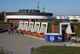
This extensive territory to the South of Pāvilosta once was the site of warehouses and an oil base. The territory at this time is used for the extraction of raw materials. There is also a sawmill there. The sign at the entrance of the facility states that the area can be dangerous to visitors.
|
|
 |
This structure is smaller than the Great Kangari hills – approximately 10 kilometres long and 16 metres high. This structure is near the Buļļi swamp, and the restricted area is meant to protect the structure, the swamp and the various forest types and rare plants that are in the area.
|
|
 |
A well-kept farm and garden, rabbits and various poultry - chickens, chicks - can be viewed. |
|
 |
Mājražošanas uzņēmums no Jaunjelgavas novada Seces pagasta. Savu hobiju (kūpināšanu) uzņēmuma saimnieks ar pieredzi papildinājis vairāku gadu garumā, taču plašākam pircēju pulkam produkcijas klāsts piedāvāts no 2013. gada. Uzņēmumā tiek kūpinātas lielākoties tikai Latvijā audzētas zivis, ar tradicionālām metodēm, izmantojot alkšņu malku, nepievienojot e-vielas. Piedāvājumā ietilpst arī kūpināta vistas gaļa, jūras asari, kā arī citi kūpinājumi. |
|
 |
The tower is on the banks of the little Tērvete River, with a view of the river valley and surrounding forests. Good views of the Tērvete River valley are also available from the nearby Zviedru Hill and the Tērvete castle hill. Note: The viewing tower at the Tērvete Ancient History Museum is not open to visitors!
|
|
 8 days
|
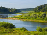
The Daugava River is known as our river of destiny, the Daugava of our hearts, or our beloved mommy. It is a large and full-blooded artery of water that has flowed through our land and our history. The Vikings were aware of the river during the 5th century AD. Krāslava is the site of an ancient castle hill, and the fearless sailors were well aware of it in that downriver from it, the ships could sail with raised sails. It is known in Viking sagas as Dynasaiforgarðr. Goods from the East sail down the river to Rīga, where it is reloaded into seafaring ships for delivery to Europe. That has been the case for many centuries. Many powers wanted to control and govern the process, as is seen in the large number of castle hills, castles and populated areas around the river’s banks. The majestic ruins of the Koknese Castle, Krustpils, the grassy and mighty castle hill at Aizkraukle, another one at Daugmale. The unique fortresses at Daugavgrīva and Daugavpils are like large keys that lock or unlock this mighty and ancient trade route. Under the water in the Daugava are the ruins of the ancient Ikšķile Castle that was built by St Maynard himself. It is seen as the first brick building in the Baltic States. Nearby is Death Island, where Latvian riflemen fought for the future of their country and their land, defending each square metre of land. The Daugava proved insurmountable for Bermont’s troops, and the riflemen defended Rīga successfully. The curves of Daugava are unique. The village of Slutišķi is particularly known because the Daugava there is just like it has been in the past. The high dolomite shorelines and canyons that once made the Daugava unique in all of Northern Europe have now been lost in the reservoirs of hydroelectric power plants, as has the eternally weeping cliff of Staburags, the Liepavotu stream and the Pērse waterfall. The age of national renaissance in Latvia importantly began with a battle against the construction of another power plant on the Daugava, which would have fully destroyed the beauty of the noble river. We managed to protect it, if only a small part of it, but we succeeded. We must not stop! |
|
 |
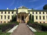
The Preiļi Estate is in the southern part of Preiļi. During the Soviet era, the mansion was home to a variety of institutions. A fire burned much of the upper part of the building in 1978. The mansion was never restored, and it can only be viewed from the outside. Around it, however, is one of Latvia’s most outstanding landscape parks (mid-19th century). Irēna Kjarkuža offers interesting tours of the state, with interesting legends and songs in the Lettigalian language. |
|
 |
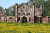
Gebaut am Ende des 18. Jh. im Stil des Frühklassizismus als der Besitz der Grafen von Mellin. Saaldekorationen vom künstlerischen Wert von K. V. Kalopka (1792) und Öfen (Ende des 19. Jh.). Ein Park. |
|
 |
The Naukšēni People’s Museum, where we tell intelligent people about those who were born at the NAUKŠĒNI DISCO, arrived here and stayed here. We’ll look at how they talk, sing, think and love. |
|
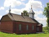 |
Bоrisovas St. Nikolay Old-Believers Prayer House was built in the period of 1911 – 1921 . The different feature of the Prayer House is a brick building placed on the hill. The bell of the temple was specially
ordered and brought from St. Petersburg. The bell has a very soft sound.
|
|
 |
Das Museum befindet sich in der Festung von Kopgalis. Im Aquarium des Museums sind Fische und Tiere der Ostsee und anderer Meere und Ozeane zu sehen. Eine Ausstellung. Pinguine und Seehunde. In den Pulverkellern der Festung ist eine Ausstellung der Seefhrt Litauens, aber auf den Bollwerken eine Ausstellung der Gewehr eingerichtet. Das einzige Delfinarium im Baltikum. |
|
 |
The cafe is situated in the guest house Zitari on the first floor, in the town of Roja, alongside the road, 500 m away from the sea. |
|
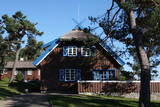 |
Ein zweistöckiges Holzhaus auf dem Uošvės-Hügel mit wunderschönem Blick aufs Haff. Hier hat drei Sommer der Träger des Nobelpreises, deutscher Schriftsteller Thomas Mann (1875 – 1955) verbracht. |
|
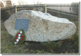 |
The memorial stone to Augusts Muižulis,a recipient of the Lāčplēsis Military Order, is placed in the Lapmežciems, at the edge of the road (P 128, Jūrmala-Talsi) at the marker for the 9th kilometre. A. Muižulis, (189 –1941) was a lieutenant colonel in the No. 4 Valmiera Infantry Brigade. The adjacent Tuteņi homestead is his native home. |
|
 |
The café is in the centre of Jēkabpils and offers pizzas, pastries, cakes, tortes and sweet pretzels, as well as cured meat, tasty venison and wild boar dishes, and products from local producers and farmers. |
|
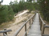 |
The trail climbs up and down along the bluffs of lower River Pilsupe and reveals a fascinating sight of three white dune exposures (the largest is called the White Dune). The trail is 900m long, and the White Dune is ca 20m high. It has formed ca 6000 years ago, in the period of the Littorina Sea which is a foregoer of the Baltic Sea. Here the first Stone Age settlement on the North Western coast of Latvia has been found in 1934 by geologist S. Burhards. In the sand, some 500m from the sea, he found some pottery fragments, a sandstone hone, a piece of flint, parts of bones and an amber bead. He handed the findings over to the National Museum of History. In October 1934, the site was checked by archaeologist E. Šturms, who found the archaeological layer, typical for such settlements, in the landslides of the Pilsupe riverbanks. In 1936 he started larger excavations to continue by 1938. Totally seven, chronologically different settlements were detected and many artefacts found, including fragments of the so called Sārnate and pit-comb pottery, as well as some pieces of corded pottery. Based on these findings, the settlement is dated back to the beginning or middle of the 3rd millenary B.C., and it has been inhabited till the beginning of the 2nd millenary B.C. Especially remarkable are three clay figures in human shape which have probably been used for some religious cult purposes. Since 1993, archaeologist Ilzes Loze has discovered several pit-comb ware culture settlements in large area around Pūrciems village. They are known in research literature as „the Ģipka settlements”. |
|
 |
In der Umgebung von der 52 m hohen Parniddenen Düne sind die im 18. Jh. bei einem Holzeinschlag entstandene Wanderdünen zu sehen! Aussichtsplatz. |
|
 |
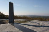
In Dagda, on the side of Daugavpils Street, there is a forested hillock that is the Lubāne castle hill. On the upper part of its southern side, there’s a viewing area which offers a view of the small Lake Lubenenis, the eastern part of Dagda, and the white tower of the local Catholic church. Legend has it that treasure is buried here.
|
|
 |
The Kemeri railroad station dates back to 1877,
when the rail line was opened. A train from Moscow
travelled to Ķemeri for awhile, and until 1920, there was
a tram leading from the train station to the beach at
Jaunķemeri. The station was destroyed during World
War I and rebuilt in 1922 (the architect was Artūrs
Medlingers). This was the first building in Ķemeri to be
erected after the establishment of Latvia’s
independence. The station building was rebuilt once
again after World War II. A bike rental facility is found
inside.
|
|


