
| No | Name | Description |
|---|---|---|
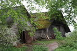 |
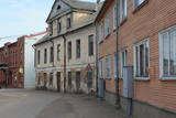
Maza apdzīvota vieta ar dažām viensētām uz pussalas (salos tulkojumā no lietuviešu valodas nozīmē „sala") starp vairākiem ezeriem. Salos II ir viens no sešiem Augštaitijas nacionālā parka etnogrāfiskajiem ciemiem. Ciems patiks tiem, kas meklē ļoti nomaļas vietas ar vecām guļbaļķu dzīvojamām un saimniecības ēkām. No Salos II pa sauszemes maršrutu var doties pārgājienā līdz Ladakalnim un Ginuču pilskalnam (sk. iepriekš). |
|
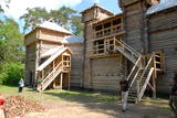 |
This is the largest exhibition in the Baltic States to feature the Semigalian material culture during the Iron Age. There is a wealth of ornamentations, weapons and household objects, including the largest collection of swords in the Baltic States. The exhibition is housed in the rebuilt defensive rooms of the wooden castle of Tērvete which existed here in the 12th century. During the second weekend of each August, there is an international Semigalian festival which is the largest Medieval festival in the Baltic States. |
|
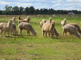 |
This is the largest herd of alpacas (an animal from the mountainous regions of South America) in the Baltic States. You can observe the animals, listen to stories about them, and buy alpaca wool. There are plans to transfer the herd to the Vīceži Estate in the Lībagi Parish in 2014.
|
|
 |
The former military field hospital is in the park, south from Ventspils Seaside Open-air Museum. A few of the small architectural forms of the building have been preserved.
|
|
 |
This is one of the oldest museums in Vidzeme and features interesting discoveries from the Middle Ages and the Iron Age, some of which were found around Lake Lubāna. Employees organise thematic exhibitions related to the culture and history of the administrative district, as well as art exhibitions. The museum is in the historical buildings of the former Birži Estate. |
|
 |
When you drive down the Nereta-Ilūkste road, the church, which was built in 1805 and restored in 1888, can be seen from a distance. The altar, pulpit and organ prospectus are all original. German soldiers who fell during World War I are buried outside of the church. Two plaques on the western wall of the building honour residents of the Laši Parish who died during the First World War, as well as those local residents who suffered Soviet repressions. |
|
 |
Atrodas ļoti skaistā vietā – Krimuldas muižas kompleksa teritorijā, vienā no muižas vēsturiskajām ēkām. Mājīgs interjers, mākslinieka J. Annmaņa apgleznotas sienas. Piedāvā turpat muižā darinātos mājas vīnus un „Muižas stipro”. Garšīgas tējas, uzkodas un siltie ēdieni. |
|
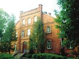 |
Rikavas Manor is the local architectural monument that belonged to Janovski family. Michael Riks
bought the building in the second half of the 18th century. The construction works of the manor house lasted
from 1870 till 1875. The redbrick building is an example of Neo Gothic style. Since 1926 there was established
a school. You should see the beautiful interior and wooden stairs as well as school’s workshop
|
|
 |
Is an ancient Courlandian castle hill and is found in the very centre of Alsunga. It was named in 1659 when General Berg from Kurzeme put cannons on it to attack Swedish forces that had fortified themselves in the Alsunga castle. The hill is 8 to 10 metres high and 24 x 54 metres wide, offering a lovely view of the St Michael Roman Catholic Church, as well as the Alsunga windmill lake that is alongside it. There is a distinct terrace around the hill, and it once was the foundation of wooden defensive structures. On the other side of the street, to the West of the castle hill, is a cemetery with fire graves of Courlandians that date back to the 11th to 13th century. Archaeologists examined the area during the middle part of the last century. The Suiti celebrate Easter and other holidays on the hill. |
|
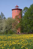 |
is the second oldest navigation structure in Latvia and the only one that is five kilometres from the shore, at the upper edge of the ancient Lake Baltic Ice. Since 2000 the lighthouse has not served its initial purpose, and now it is the home to the Nature Education Centre "Slītere" of the Slītere National Park. The centre offers exhibitions about lighthouses in Latvia and the history of the Baltic Sea. From the upper floor (102 m above sea level) one can see the coast of Saaremaa (approximately 33 km away). Alongside the lighthouse is the 1.2 km Šlītere nature trail. |
|
 |
"Līdumkalni" atrodas Ķurbē -Kurzemes ziemeļrietumu daļā, starp Dundagas mežiem un Ķurbes lielo silu, zaļu pakalnu vidū, 15 km no jūras un ne pārāk tālu no debesīm. Šeit laiks rit lēni. Tas nevienu nesteidzina. Laika pietiek, lai vērotu Dieva radīto pasauli un ieskatītos Viņa bagātajā aptiekā. Laika pietiek lai iepazītos ar kristīgajām tradīcijām un dzīvesveidu, lai iegūtu praktisku lūgšanu un meditāciju pieredzi. Laika pietiks arī veselīgas maltītes pagatavošanai lauku virtuvē vai uz ugunskura un pašam savas gleznas uzgleznošanai gleznotājas darbnīcā. |
|
 |
The former Ķemeri swimming facility used
to have a building of wooden bathtubs in the
19th century. The mud treatment facility which
is designed in the style of Classicism was
erected in 1924. The Ķemeri clinic was opened
here after World War II. A monument to Ivan
Pavlov, a distinguished Russian doctor and
physiologist is on the western end of the ruins,
and no one has taken much care of it, either.
|
|
 |
This park is in a region of hillocks in the Karula highlands, and Lake Ähijärve is at its centre. The park offers a cultural environment of small farms, and it was set up to protect the unique cupola-shaped hillocks of the area. Main attractions: Scenic Lake Ähijärv (176ha), Rebasemõisa Tornimägi hill (137.8 m above sea level), undulating landscapes. |
|
 |
The saloon is in the centre of Jēkabpils near the Daugava River dam. It offers exotic dishes. Latvian cuisine: Cheese salad, wild mushroom soup, ramekin of chicken or pork, strawberry soup with ice cream. |
|
 |
The loveliest views of the local cultural and historical treasures (the Āraiši lake castle, the Lutheran church, the parsonage, Medieval castle ruins – all of these cultural monuments). The hillocks of the area which offers this view can be found in the immediate proximity of the Āraiši windmill and the Drabeši-Āraiši road.
|
|
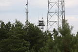 |
The military communications facilities at Pāvilosta are along the southern part of the town. The facilities are owned by the local government, and there is no information about their use at this time.
|
|
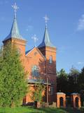 |
Holy Trinity Roman Catholic Church of Stoļerova. The construction
works of the church were finished in 1999 by the support of dean Butāns. The building is slightly larger than
the previous one; the newest (restored) church in Rēzekne district. The church has a specific icon of Our
Lady that was transferred from the chapel of Rozenmuiža.
|
|
 |
Aizputes pilsdrupas, akmens tilts pār Tebru, Jaunā pilsmuiža, ūdensdzirnavas un Sv. Jāņa luterāņu baznīca, kā arī 19. gs. beigās celtās koka ēkas starp Jāņa, Katoļu un Atmodas ielu veido neparastu pilsētbūvniecības kompleksu, kam piešķirts kultūras pieminekļa statuss. Staigājot pa vēsturisko centru, uzmanība jāpievērš ēku durvīm un to vērtnēm, logu ailēm, balkonu margām u.c. elementiem. |
|
 |
On the third Saturday of each month from 9:00 to 13:00 the Green market takes place in Gulbene, where there are gathered outworkers, craftsmen and farmers from different districts of Latvia. There are offered goods made by the outworkers, seasonal vegetables and fruit, as well as beauty and design products, including other useful household and pretty goods. |
|
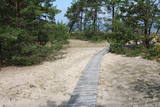 |
The trail (the length 1.2 km) introduces with the habitats of dunes and century-old pines, partly covered with sand. Biologists estimate that the oldest tree, the “mother of pines”, could be around 200 years old. Coastal pine forests serve as a barrier between the sea and land protecting inland areas from impact of the sea and winds. Felling coastal forests was forbidden by law already back in 1643, during the Duchy of Courland. Still due to economic activities, the seashore forests were often fell and fires occurred there occasionally. As a result, the sand which had for centuries been hold by trees, started drifting at Cape Kolka. In the 1930ies, there were about 142 hectares of sandy areas in the Slītere National Park, and 11.5 hectares of those were drifting sand. To stop drifting, the sand areas were carefully afforested. Afforestation was started before WW I and it was completed in the 1970ies. To plant new trees, first the sand had to be stopped. Just 26km to the south from Kolka there was one of the largest sand dunes in Latvia, 25km in length. Every year it devoured 0.3 hectares of land. The sand was stopped covering it with heather, twigs and branches of pines and junipers. Pine trees were planted between them. Today in Kolka, the old, low pine trees tell about the once drifting sand. After storms, when the water washes the bluff and tree roots are exposed, one can see that the tree trunks once have been covered with sand more than 1 meter high. The trees on the seacoast usually have crooked trunks and flag-shaped crowns formed under influence of persisting sea winds. Now these forests are designated biotope “Wooded dunes of the coast”. Stable white dunes (biotope 2120) do not form in Cape Kolka as they are washed by sea waters during spring and autumn storms. Embryonic dunes develop here (code 2120) with plants that usually grow in dunes. These plants have adapted well to poor soils, heat, drought, and the saline sea water. The Kolkasrags Pine Trail is in Slītere National Park. |
|


