
| Нo | Название | Описание |
|---|---|---|
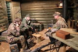 |
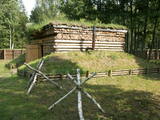
Pie Vidzemes šosejas pirms Melturu tilta pāri Amatai ir privātais muzejs "Mežabrāļu bunkurs". Bunkurs izveidots, lai varētu vēstīt par Nacionālo partizānu mežabrāļu cīņu laikā no 1944.-1956. gadam, kad mežos pret okupācijas varu cīnījās ap 20 000 Latvijas patriotu. Nacionālo partizānu bunkurs izveidots balstoties uz savāktajām mežabrāļu atmiņām, dienasgrāmatu pierakstiem un fotogrāfijām. Uz bunkuru ved meža taka ar informāciju par dažādiem mežabrāļu piedzīvojumiem un cīņām. Bunkura pazemes daļā apskatāmi vēsturiskie priekšmeti, kas viņus pavadīja dzīvē un cīņā. Saimnieks piedāvā pastaigu pa meža taku, kur izvietota informācija par mežabrāļiem un slēpņu spēle bērniem. Ar iepriekšēju pieteikšanos iespējams iekļūt bunkurā un apskatīt iekārtotu bunkuru ar mežabrāļu izmantoto ieroču, munīcijas un citu priekšmetu ekspozīciju. Stāstījumu papildina savāktās mežabrāļu interviju videoieraksti. Apmeklētājiem iespējams pasūtīt mednieku desiņu cepšanu lapenē pie bunkura. |
|
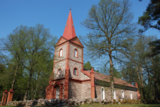 |
Здание церкви было построено в 1835 году. Его гордостью является орган, который в 1854 году был построен Карлом Битнером. Проводится восстановление поместья приходского священника. Прокат лодок. |
|
 |
The trail tells about grey dunes which have survived thanks to the border restrictions and the presence of military. The trail starts from the parking place at the mouth of the Užava river. It is one of the few natural rivermouths in Europe. One can also see the „tacis”, an industrial installation for lamprey (Lampetra fluviatilis) fishing during their spawning migration period. The 3km long trail is circular. It winds for 1.5km from the Užava rivermouth to the North, along the coastline (the beach is covered with sand and pebbles), and returns to the starting point by a gravel road through grey dunes. Along the trail, one can observe a distinct white dune with rare plant species Linaria loeselii, Lathyrus maritimus, Anthyllis arenaria, Tragopogon heterospermus. About 1km from the rivermouth, in the sea, one can see a wrack of a sailing ship (parts of frame). The visibility depends on the flow of sand in the sea. The way back opens a beautiful view of the range of grey dunes. Unfortunately, Scots Pine starts taking over the area. There are three important biotopes of EU significance: „Fixed dunes with herbaceous vegetation 2130”, „Decalcified fixed dunes with Empetrum nigrum 2140” and „Dunes with Salix arenaria 2170”, forming a unique mosaic. Typical species here: mountain Alison ‘(Alyssum gmelinii), Pasqueflower (Pulsatilla pratensis), Sand Pink (Dianthus arenarius), Rosemary Leaved Willow (Salix rosmarinifolia), Dark Red Helleborine (Epipactis atrorubens), Kinnikinnick (Arctostaphylus uva-ursi). As a former military site, some military constructions can be seen here like horseshoe-shaped sand ramparts by the road in gray dunes. They were built to disguise military vehicles in case of sea attack. By the Kangroti graveyard, towards the Užava river, there is an underground pillbox. It is a one-man fortification to fire along the coastal perimeter. The Mouth of River Užava walking route is in the nature reserve „Užava” |
|
 |
Хозяйка встретит вас небольшим рассказом о выращенном в хозяйстве здоровом травяном чае и испеченными ею лакомствами. Если есть желание провести ночь под открытым небом, мы предлагаем места для палаток и костров, расположенные на берегу реки возле старой мельницы Луку. Крестьянское хозяйство «Аплоки» ждет каждого, кто хочет отдохнуть в тихой и спокойной атмосфере. |
|
 |
В 1242 году на этом месте немецкий орден построил каменный замок, от которого до сегодняшнего времени сохранились только отдельные фрагменты стен и свод подвала, в котором по предварительной договоренности можно заказать дегустацию вина местного производства. В более поздние времена здесь находился замок герцога Курземе, который был разрушен во время Северной войны (1701 год). В результате проекта реконструкции парка созданы деревянные мостки, информационные стенды, построена беседка и фонтан. В парке возведены отдельные скульптуры и их группы (22 скульптуры, автор Ливия Разевска). |
|
 |
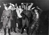
Место, где во время Второй мировой войны в 1916 году прошли так называемые Рождественские бои между войсками Германии и России, после которых слава о мужестве и героизме латышских стрелков прозвучала далеко за пределами страны. На Пулеметной горке создано мемориальное место латышским стрелкам и восстановлена смотровая вышка. С нее хорошо просматривается болото Мазтиреля с линией бывшей немецкой узкоколейной железной дороги, которая пересекает его в северо-южном направлении. Здесь можно прогуляться как в сопровождении гида, так и без него, посетить дом Мангали музея Рождественских боев, рядом с которым был создан особый познавательный маршрут, поучаствовать в тематических образовательных мероприятиях и в постановках боев. Можно осмотреть памятники, захоронения воинов, траншеи, фортификации, землянки и многое другое. Также можно осмотреть так называемый «Немецкий вал» - реконструированный участок оборонной системы – блиндаж и часть передовой линии немецкой обороны. |
|
 |
Hauptstadt von Hiiumaa. |
|
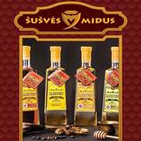 |
Организуются ознакомительные дегустации мидуса и мёда. Здесь можно приобрести разные продукты пчеловодства, свечи из натурального воска, мидус нескольких сортов. |
|
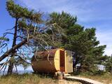 |
Место для отдыха Лаймес майя находится в очень красивом месте у самого берега моря – на мысе Колка. Здесь у вас будет возможность отдохнуть, наблюдать за закатами и восходами, наслаждаться морем, тишиной и покоем. Дом Лаймес – это экологическая постройка цилиндрической формы из еловой древесины с большим круглым зеркальным окном. У дома Лаймес характерная форма круглой бочки, что придает ей оригинальность и красивый дизайн. На одном конце дома расположено большое полукруглое окно, через которое открывается красивый пейзаж за окном. Кровать в доме расположена прямо у окна, для того, чтобы предоставить незабываемые, романтические ощущения при единении с окружающим пейзажем и природой. |
|
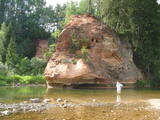 |
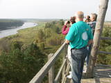
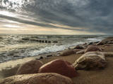
This is one of the most beautiful and popular tourism locations in Vidzeme. The cliff is 45 metres high, and the height of the lovely open-faced portion is around 20 metres high. You can look at the wide and deep Amata River valley and its forested banks.
|
|
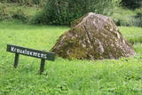 |
Rīgas – Daugavpils šosejas (A 6) malā (vietā, kur no Zemkopības institūta nogriežas ceļš uz Skrīveriem) redzama zema ieplaka ar Kraukļu akmeni, kas ir sena kulta vieta. Pie akmens veikti arheoloģiskie izrakumi, kuru laikā atrastas senlietas. Vecākā ir no 12. gadsimta. Akmens aprakstīts slavenajā Andreja Upīša (1877. – 1970.) darbā „Sūnu ciema zēni”. |
|
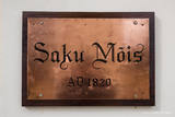 |
This manor is a prime example of classical architecture in Estonia. Since 2002 Saku manor is also a recreational centre. |
|
 16 дней
|
This tour is a road trip from Rīga to Vilnius, stopping along the road to hike on nature trails of the Baltic Coastal Hiking Route. In Latvia the route mainly follows the Baltic Coastal Hiking Route/ the Baltic coast, continuing along the coast and the Curonian Spit in Lithuania. Further, the route includes some smaller sections of the Forest Trail in Lithuania leading to Druskininkai and near the Lithuanian/Polish border. This tour will suit travellers who are ready to indulge in some nature trails and have a peek in urban landscapes, but who are not prepared for longer distances with backpacks, tenting and similar. A car will take you from one short hike to the next. Another transfer is planned from the island of Rusnė to the Dubysa valley, thus linking the Lithuanian sections of the Baltic Coastal Hiking Route and the Forest Trail. The tour includes Latvian and Lithuanian nature’s jewels – the national parks of Ķemeri and Slītere, Cape Kolka, Pape Nature Park, the Curonian Spit, the island of Rusnė, the river Nemunas, the Dubysa river valley regional park with its rolling terrain, the most forested and secluded area of Lithuania – the Dzūkija National Park. Besides the capital cities of both countries, the route will take you to other major cities – Ventspils, Liepāja, the popular resort town of the Curonian Spit – Nida, as well as historical bathing resorts: Ķemeri, Birštonas and Druskininkai. You will also see the city of Kaunas and the beautiful riverscapes of the river Nemunas. |
|
 |
Старая деревянная башня была снесена, и на ее месте сейчас построена новая вышка. С построенной в 2015 году вышки открывается один из самых красивых природных видов Латвии, который в свое время был изображен на 10-латовой банкноте. Вид на эту излучину Даугавы считается самым красивым на протяжении всего течения реки. |
|
 |
The Soviet Border Guard arrived at Lapmežciems (its border with Ragaciems) in the mid-1960s and left in 1991. Some 50 military personnel were stationed here. The military personnel and local residents organised various events and celebrations. The only thing that worried locals was a radar which was said to cause various problems. The zenith missiles were dismantled and taken away in 1991. An apartment building is still on what was then the military base. |
|
 5 дней
|
Историки утверждают, что ливы на древней территории Латвии появляются с 10-го века. Они селятся в Северной Курземе, в низовьях Даугавы и Гауи. У первых приплывших немецких торговцев они интересуются со знанием дела – Сколько сейчас стоит сукно на рынке в Висбю? Значит, им известен шведский остров Готланд, они хорошие мореплаватели, смелые и сильные духом. Только сильный может ужиться с морем, отправляться на ловлю рыбы и тюленей, укорениться в отнюдь не плодородных песках морского побережья. |
|
|
|
Entstanden als eine 6 km entfernte Arbeiterstadt des schon geschlossenen Ignalina-Atomkraftwerks. In der Stadtbebauung dominieren die für die Sowjetzeit typischen architektonischen Formen und Monumentalbauten. |
|
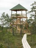 |
This is part of a hiking trail along the Cena bog. It is on the western side of the bog, at the centre of the 5-kilometre circular trail. You can see the vast swamp, as well as a military road that was installed during World War I and is marked by an “alley” of large pine trees. Alongside the tower is a fragment of the road that was installed more recently.
|
|
 |
Место, где можно не только переночевать, но и полюбоваться природой и насладиться кухней. Трактир Kogre получил свое название благодаря «супу из семи рыб» ‒ карась (koger) является седьмой по счету рыбой. Хозяин этого заведения ‒ рыбак, и они вдвоем с женой готовят разные блюда из собственноручно пойманной рыбы. |
|
 |
Karņicka kalns pēc savas izcelsmes nav kalns, bet gan Daugavas ielejas nogāzes daļa ar labu skatu uz Krāslavas mazstāvu koka apbūvi. Ar šo vietu saistīts traģisks nostāsts par poļu virsnieka Josifa Karņicka un grāfa Plātera meitas mīlestību, kurai nebija lemts piepildīties tā laika „paražu” dēļ. Tā rezultātā abi nelaimīgie nolemj izdarīt pašnāvību. Virsnieks nošaujas, bet Emīliju pēdējā brīdī izglābj kalpone, neļaujot tai izlēkt pa pils logu. J. Karņicka pašnāvības vietā ir uzstādīts piemineklis. Nedaudz tālāk – rietumu virzienā guļ t.s. Austriņa akmens, pie kura 1909. gadā iedvesmojies un radījis latviešu rakstnieks Antons Austriņš. |
|


